

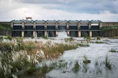
How To Reach Pitamahal Dam
How to Reach
By Train: The nearest major railway station is Rourkela Railway Station (ROU), located approximately 22 KMS away. One can hire an auto-rickshaw or a private taxi directly from the station to the dam.
By Road: The dam is best reached by road, via a approximately 22 KMS journey from Rourkela city center. One can take a local bus towards Balanda village or, preferably, hire a private taxi or an auto-rickshaw for a comfortable, door-to-door trip. The route is primarily via State Highway 10 followed by local connecting roads.
By Local Transport: While local buses run, a hired private vehicle or taxi is the most convenient option, as the dam is in a slightly remote location. :
Information about New and Updated Locations(711+) of Odisha Has Been Added :-
Card subtitle
Note:-
Information provided here in good Faith and for reference only.
All information and pictures will be updated soon, please keep visiting.
Near Places
Ahirabandh
Some quick example text to build on the card title and make up the bulk of the card's content.
Go somewhere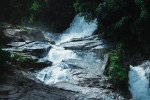
Badaghagra Falls
Some quick example text to build on the card title and make up the bulk of the card's content.
Go somewhere
Badalgiri Waterfall
Some quick example text to build on the card title and make up the bulk of the card's content.
Go somewhere
Biju Patnaik Hockey Stadium
Some quick example text to build on the card title and make up the bulk of the card's content.
Go somewhere
Birsa Munda Intl Hockey Stadium
Some quick example text to build on the card title and make up the bulk of the card's content.
Go somewhere
Chhatri Hill
Some quick example text to build on the card title and make up the bulk of the card's content.
Go somewhere
Darjing Picnic Spot
Some quick example text to build on the card title and make up the bulk of the card's content.
Go somewhere
Deodarha Picnic Spot
Some quick example text to build on the card title and make up the bulk of the card's content.
Go somewhere
Gayatri Temple
Some quick example text to build on the card title and make up the bulk of the card's content.
Go somewhere
Ghoghar Temple
Some quick example text to build on the card title and make up the bulk of the card's content.
Go somewhere