

Kalinga Ghat
General information
-
Ideal Duration:
1 Hour (Transit/Stop)Place Type:
Nature / ViewpointEntry Fees:
Free Access: There is no entry fee to drive through the ghat.
Forest Toll: A small environmental toll of 50 INR may be charged for commercial vehicles at the entry check-post. ...Free Access: There is no entry fee to drive through the ghat.
Forest Toll: A small environmental toll of 50 INR may be charged for commercial vehicles at the entry check-post.Timing:
Standard Hours: Open 24 hours, but driving between 6:00 AM and 6:00 PM is highly recommended for safety.
Ideal Visit: Early morning (around 7:00 AM) for the best mist and bird activity. ...Standard Hours: Open 24 hours, but driving between 6:00 AM and 6:00 PM is highly recommended for safety.
Ideal Visit: Early morning (around 7:00 AM) for the best mist and bird activity.Special Events:
Monsoon Greenery: The ghat transforms into a wall of emerald green during July, with small seasonal waterfalls appearing at every turn.
Foggy Winter mornings: A natural "event" where visibility drops to near zero, creating a magical, eerie l...Monsoon Greenery: The ghat transforms into a wall of emerald green during July, with small seasonal waterfalls appearing at every turn.
Foggy Winter mornings: A natural "event" where visibility drops to near zero, creating a magical, eerie landscape.Best Photo Spots:
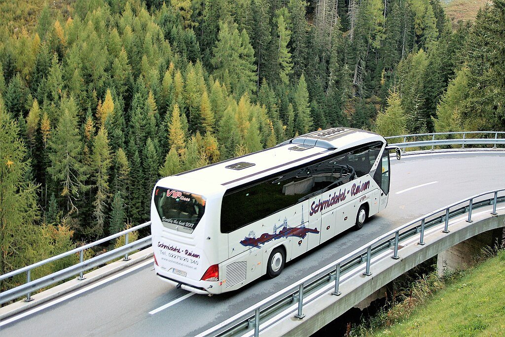
The Valley Curve: Capture the road snaking through the forest from an elevated angle.
Misty Horizon: Take photos when the clouds settle in the valley, creating a "sea of milk.
" Sunset Ridge: The peaks visibl...The Valley Curve: Capture the road snaking through the forest from an elevated angle.
Misty Horizon: Take photos when the clouds settle in the valley, creating a "sea of milk.
" Sunset Ridge: The peaks visible from the ghat catch the last orange rays of the sun beautifully.Photo Gallery
Things To Do
-
Mountain Driving: Experience the thrill of navigating the sharp curves of the Eastern Ghats.
Panoramic Photography: Stop at the "View Point" to capture the endless green ridges stretching to the horizon.
Bird Watching: Look for the Malabar Whistling Thrush which is often heard in the deeper sections of the forest.
Selfie at Hairpin Bends: Safely pull over at the widened sections for a classic "mountain road" selfie.
Nature Sketching: The dramatic landscape is a favorite for artists and landscape painters.
Cycling: For professional cyclists, the ghat offers a challenging uphill climb with rewarding views.
Picnicking: There are a few small clearings where you can e...Mountain Driving: Experience the thrill of navigating the sharp curves of the Eastern Ghats.
Panoramic Photography: Stop at the "View Point" to capture the endless green ridges stretching to the horizon.
Bird Watching: Look for the Malabar Whistling Thrush which is often heard in the deeper sections of the forest.
Selfie at Hairpin Bends: Safely pull over at the widened sections for a classic "mountain road" selfie.
Nature Sketching: The dramatic landscape is a favorite for artists and landscape painters.
Cycling: For professional cyclists, the ghat offers a challenging uphill climb with rewarding views.
Picnicking: There are a few small clearings where you can enjoy a quick snack while looking at the valley.
Information
-
Why Famous:
Longest Ghat Road: Famous for being one of the longest ghat sections in the state, offering an adrenaline-filled driving experience.
Mist and Fog: Renowned for its heavy fog cover during winter mornings, which creates a "Kashmir-like" atmosp...Longest Ghat Road: Famous for being one of the longest ghat sections in the state, offering an adrenaline-filled driving experience.
Mist and Fog: Renowned for its heavy fog cover during winter mornings, which creates a "Kashmir-like" atmosphere. -
Architecture:
Engineering Marvel: The road architecture features over 10 major hairpin bends. The road width is approximately 7 meters, allowing for two-way traffic but requiring careful navigation.
Retaining Walls: Massive stone and concrete retaining w...Engineering Marvel: The road architecture features over 10 major hairpin bends. The road width is approximately 7 meters, allowing for two-way traffic but requiring careful navigation.
Retaining Walls: Massive stone and concrete retaining walls, some standing 20 feet high, prevent landslides and provide stability to the steep mountain slopes. -
How To Reach:
By Air: Bhubaneswar Airport is 230 KMS away.
By Train: Berhampur Railway Station is 100 KMS away.
By Road: This is the main road connecting Berhampur to Daringbadi.
Local Transp...By Air: Bhubaneswar Airport is 230 KMS away.
By Train: Berhampur Railway Station is 100 KMS away.
By Road: This is the main road connecting Berhampur to Daringbadi.
Local Transport: Best reached by private car or the state transport (OSRTC) buses. -
Weather and Best Time to Visit:
-
Near Tourist Places:
Phulbani (60 KM), Berhampur (100 KM), Daringbadi Town (35 KM), Hill View Park (38 KM), Nature Park (39 KM), Coffee Garden (40 KM), Pine Forest (36 KM), Sunset Point (42 KM), Emu Farm (49 KM), Lovers Point (50 KM).
Tourism Tips
-
Driving Safety: Use lower gears while descending; do not overtake on sharp curves.
Wildlife: Do not feed monkeys or other animals on the road.
Cash: No ATMs for miles; ensure you have enough fuel and cash ...Driving Safety: Use lower gears while descending; do not overtake on sharp curves.
Wildlife: Do not feed monkeys or other animals on the road.
Cash: No ATMs for miles; ensure you have enough fuel and cash before starting the climb.
Connectivity: Network is very poor in the middle of the ghat; download offline maps.
Reviews
FAQs
Daringbadi Itineray And Cost:-
Information about New and Updated Locations() of Odisha Has Been Added :-
Card subtitle
Note:-
Information provided here in good Faith and for reference only.
All information and pictures will be updated soon, please keep visiting.
Near Places
Bada Sahi Water Reservoir
Some quick example text to build on the card title and make up the bulk of the card's content.
Go somewhere
Badangia Waterfall
Some quick example text to build on the card title and make up the bulk of the card's content.
Go somewhere
Baliguda Town
Some quick example text to build on the card title and make up the bulk of the card's content.
Go somewhere
Belghar Nature Camp
Some quick example text to build on the card title and make up the bulk of the card's content.
Go somewhere
Chakapad Temple
Some quick example text to build on the card title and make up the bulk of the card's content.
Go somewhere
Dadapali Waterfall
Some quick example text to build on the card title and make up the bulk of the card's content.
Go somewhere
Dadubandha Village
Some quick example text to build on the card title and make up the bulk of the card's content.
Go somewhere
Daringbadi Church
Some quick example text to build on the card title and make up the bulk of the card's content.
Go somewhere
Doluri Waterfall
Some quick example text to build on the card title and make up the bulk of the card's content.
Go somewhere
Emu Farm
Some quick example text to build on the card title and make up the bulk of the card's content.
Go somewherein Other Cities