Raja's Fort Ruins
General information
-
Ideal Duration:
1 to 2 Hours: (For trekking to and exploring the ruins)Place Type:
Historical Site/Trekking Destination: (Medieval RuEntry Fees:
No Entry Fee: Access to the ruins is Free of Cost, as it is an unmaintained historical site within the open forest area.
Forest Entry Fee: If the starting point of the trek is within a regulated Forest Department area, a nominal entry fee (a...No Entry Fee: Access to the ruins is Free of Cost, as it is an unmaintained historical site within the open forest area.
Forest Entry Fee: If the starting point of the trek is within a regulated Forest Department area, a nominal entry fee (approx. INR 50 to INR 100) may be charged per person for entering the reserve.
Guide Fee (Optional): Since the ruins are hidden and access is via forest trails, it is highly recommended to hire a local guide, who may charge around INR 300 to INR 500 for the round trip, a cost that is voluntary but highly advisable for safety and navigation.
No Facility Costs: There are no formal facilities (toilets, shops, etc. ) and thus no associated usage fees.Timing:
Regular Timings: Accessible 24 Hours, but strictly advised only during Daylight Hours (7:00 AM to 5:00 PM) due to the remote location, lack of lighting, and presence of wildlife.
Ideal Visit Time: The Ideal Visit Time is the Morning (8:00 AM...Regular Timings: Accessible 24 Hours, but strictly advised only during Daylight Hours (7:00 AM to 5:00 PM) due to the remote location, lack of lighting, and presence of wildlife.
Ideal Visit Time: The Ideal Visit Time is the Morning (8:00 AM to 10:00 AM) to enjoy the cool weather for the trek and the soft light for photography. Late Afternoon (3:00 PM to 4:00 PM) is also good for the sunset view from the fort’s elevated position.
Avoid Mid-Day Trekking: The trek should be avoided during the peak sun hours (11:00 AM to 3:00 PM) due to heat and humidity, especially during the Summer and Pre-Monsoon months.Special Events:
Historical Trail Walks: The local forest department or adventure tourism operators occasionally organize guided, themed Historical Trail Walks to the fort ruins, often during the Winter season, featuring a local guide to narrate the history of the Paigah Nawabs and the fort....Historical Trail Walks: The local forest department or adventure tourism operators occasionally organize guided, themed Historical Trail Walks to the fort ruins, often during the Winter season, featuring a local guide to narrate the history of the Paigah Nawabs and the fort.
Archival Documentation: Students of history or architecture sometimes organize small, special events focused on documenting and sketching the ruins, bringing a scholarly, focused group to the site to study the fragments of medieval Deccan architecture.
Monsoon Adventure Trek: The trek to the ruins becomes a special event during the Monsoon (July to September) when the path is slippery and the ruins are partially covered in mist, offering a challenging and dramatic adventure for trekkers.Best Photo Spots:
The Overgrown Wall Textures: A close-up, high-detail shot of the crumbling, moss-covered stone walls, emphasizing the texture and the plant life growing from the cracks, conveying a powerful sense of age and decay.
Framing the View: Using a ...The Overgrown Wall Textures: A close-up, high-detail shot of the crumbling, moss-covered stone walls, emphasizing the texture and the plant life growing from the cracks, conveying a powerful sense of age and decay.
Framing the View: Using a remaining archway or a partial window of the ruins to frame the distant green hills, creating a photograph that connects the historical structure to the natural landscape.
The Trekking Trail Photo: A shot of the last part of the forest trail leading directly up to the fort ruins, with a trekking companion walking ahead, symbolizing the journey and the reward of the hike.
Shadows of the Bastions: Capturing the long shadows cast by the surviving bastions or walls in the late afternoon light, which dramatically highlights their shape and former defensive purpose.Photo Gallery
Things To Do
-
Moderate Forest Trekking: Start the trek from the main road or the temple area to reach the ruins, navigating the forest paths, which is the main activity and takes about 30 minutes to 1 hour one way, depending on the starting point.
Historical Exploration: Carefully walk through the ruins, imagining the layout of the fort, examining the thickness of the old stone walls, and looking for remnants of bastions and arches, appreciating the scale of the structure.
Photography of Ruined Architecture: Focus on capturing the texture of the old stone and the dramatic contrast of the crumbling walls against the vibrant green of the encroaching forest, symbolizing the passage of time.
Picnicking in the Historical Shade: Find a safe, comfortable spot near the ruins (avoiding...Moderate Forest Trekking: Start the trek from the main road or the temple area to reach the ruins, navigating the forest paths, which is the main activity and takes about 30 minutes to 1 hour one way, depending on the starting point.
Historical Exploration: Carefully walk through the ruins, imagining the layout of the fort, examining the thickness of the old stone walls, and looking for remnants of bastions and arches, appreciating the scale of the structure.
Photography of Ruined Architecture: Focus on capturing the texture of the old stone and the dramatic contrast of the crumbling walls against the vibrant green of the encroaching forest, symbolizing the passage of time.
Picnicking in the Historical Shade: Find a safe, comfortable spot near the ruins (avoiding unstable walls) to have a light, packed lunch or a snack, enjoying the quiet historical ambiance.
Bird Watching: The secluded nature of the ruins makes it an excellent, quiet spot for bird watching, as the birds are less disturbed here than at the main tourist areas.
Storytelling and Imagination: Use the location to narrate or imagine historical tales of the Nizams and forest life, utilizing the atmosphere to bring history alive.
Nature Trail Cleanup: If organized or prepared, carry a small trash bag and help clear any litter found around the ruins, contributing to the preservation of the historical site.
Information
-
Why Famous:
Historical Link to the Nizams: Its primary fame stems from being a tangible link to the Paigah noble, Nawab Viqar-ul-Umra, who was granted the Vikarabad region and used the hills for royal hunting and retreat, giving the ruins a regal, if fragmented, past.
Read MoreHistorical Link to the Nizams: Its primary fame stems from being a tangible link to the Paigah noble, Nawab Viqar-ul-Umra, who was granted the Vikarabad region and used the hills for royal hunting and retreat, giving the ruins a regal, if fragmented, past.
A Trekking Reward: It is famous among the adventure community as a rewarding destination at the end of a moderately challenging forest trek, providing a historical structure as the prize for the exertion.
Atmosphere of Mystery and History: The ruins' dilapidated state and the way they are being reclaimed by the dense forest create a mysterious and evocative atmosphere, making the spot famous for those who appreciate the romance of ruins.Architecture:
Defensive Deccan Medieval Architecture: The fort's architecture, while only visible in ruins, points to a simple, pragmatic Deccan medieval style, focused on defense and the use of local, readily available stone.
Thick Stone Walls and Ramparts:<...Defensive Deccan Medieval Architecture: The fort's architecture, while only visible in ruins, points to a simple, pragmatic Deccan medieval style, focused on defense and the use of local, readily available stone.
Thick Stone Walls and Ramparts: The most prominent surviving features are the portions of the outer walls, constructed from large, un-mortared or roughly dressed local granite and basalt stones, indicating a thickness of approximately 3 to 4 feet for defensive strength.
Bastions (Burj) Remains: The corners of the fort perimeter likely featured small, circular or semi-circular bastions (burj), now mostly crumbled, which would have offered a 180Rs.degree firing view over the slopes.
Weathered Gateway: The entrance area may contain the remnants of a sturdy, single-arch gateway, often featuring a simple, unadorned stone frame.
Overall Dimension: The original fort was likely a small garrison or complex, perhaps spanning an area of 200 feet ×150 feet, but the present ruins are highly scattered and consumed by the jungle, presenting a fragmented picture of its former architectural dimension. The focus is on the ruins' patina of age.How To Reach:
By Air: The nearest major airport is Rajiv Gandhi International Airport (HYD) in Hyderabad (98 KMS). The journey requires a taxi to Vikarabad town and then a local vehicle to the trekking start point near the Ananthagiri Temple.
By Train: T...By Air: The nearest major airport is Rajiv Gandhi International Airport (HYD) in Hyderabad (98 KMS). The journey requires a taxi to Vikarabad town and then a local vehicle to the trekking start point near the Ananthagiri Temple.
By Train: The closest station is Vikarabad Junction (VKB), about 8 KMS away. From the station, take an auto-rickshaw or taxi to the main Ananthagiri Temple parking area, which is the nearest recognizable landmark and common starting point for the trek.
By Road: The ruins are reached by driving to the Ananthagiri Hills main area and then embarking on a trek. There is No Direct Road Access to the ruins themselves. Ensure your vehicle is securely parked at a recognized spot near the Temple or Haritha Resort before beginning the hike.
By Local Transport: A dedicated auto-rickshaw to the Temple parking area is the final point of vehicular access. A hired local guide is essential to navigate the final, unpaved forest trail to the ruins.Weather and Best Time to Visit:
Seasonal Preference: Winter (October to March) is the Best Time to Visit as the weather is cool and perfect for the strenuous trek through the forest, with low chances of rain and high visibility. Monsoon offers lush greenery but the trek is challenging due to slippery and ...Seasonal Preference: Winter (October to March) is the Best Time to Visit as the weather is cool and perfect for the strenuous trek through the forest, with low chances of rain and high visibility. Monsoon offers lush greenery but the trek is challenging due to slippery and muddy paths.
Different Parts of the Day: Early Morning is ideal for the trek to avoid the heat. The view from the ruins, however, is magical in the Late Afternoon, with the sun low in the sky, creating dramatic shadows and a soft, golden light on the stone.Near Tourist Places:
Anantha Padmanabha Swamy Temple (2 KMS), Bachelors View Point (3-4 KMS), Pital Point (4 KMS), Ananthagiri Photo Point (4 KMS), Haritha Valley Resort (3 KMS), Vikarabad Sunrise View Point (5 KMS), View Point Forest Dept (5 KMS), Shiv Sagar Lake (9 KMS), Kotipally Reservoir/Nagasamudram Lake (22 KMS), Laknapur Project (16 KMS).Tourism Tips
-
Health & safety: Always Hire a Guide or go with a local who knows the trail well, as the path is unmarked and easy to get lost on. Wear full-sleeved clothing to protect against insects and thorny bushes.
Packing Essentials: Carry a compass/...Health & safety: Always Hire a Guide or go with a local who knows the trail well, as the path is unmarked and easy to get lost on. Wear full-sleeved clothing to protect against insects and thorny bushes.
Packing Essentials: Carry a compass/GPS, sufficient water, energy bars, and a small, sharp knife for emergencies. Trekking poles are highly recommended for stability on the uneven terrain.
Accommodation Options: Stay is available at the Haritha Valley Resort (closest) or in hotels/lodges in Vikarabad town. Camping is possible nearby with prior Forest Department permission.
Other Tips: Do Not Disturb the Ruins or attempt to climb on fragile walls. Be alert for small wildlife, especially snakes and insects. Carry out all your trash to maintain the pristine nature of the historical site.
Reviews
FAQs
Vikarabad Itineray And Cost:-
Raja's Fort Ruins Tourism:-
Information about New and Updated Locations() of Telangana Has Been Added :-
Card subtitle
Note:-
Information provided here in good Faith and for reference only.
Near Places
Anantha Padmanabha Swamy Temple
Some quick example text to build on the card title and make up the bulk of the card's content.
Go somewhere
Ananthagiri Hills Forest
Some quick example text to build on the card title and make up the bulk of the card's content.
Go somewhere
Ananthagiri Hills
Some quick example text to build on the card title and make up the bulk of the card's content.
Go somewhere
Ananthagiri Photo Point
Some quick example text to build on the card title and make up the bulk of the card's content.
Go somewhere
Bachelors View Point
Some quick example text to build on the card title and make up the bulk of the card's content.
Go somewhere
Dharur Village Centre
Some quick example text to build on the card title and make up the bulk of the card's content.
Go somewhere
Godamguda Village
Some quick example text to build on the card title and make up the bulk of the card's content.
Go somewhere
Kotepally Check Dam & Kayaking
Some quick example text to build on the card title and make up the bulk of the card's content.
Go somewhere
Kotepally Lake Boating
Some quick example text to build on the card title and make up the bulk of the card's content.
Go somewhere
Kotpally Reservoir
Some quick example text to build on the card title and make up the bulk of the card's content.
Go somewhere
Laknapur Project
Some quick example text to build on the card title and make up the bulk of the card's content.
Go somewhere
Mini Water Falls
Some quick example text to build on the card title and make up the bulk of the card's content.
Go somewhere
Pital Point
Some quick example text to build on the card title and make up the bulk of the card's content.
Go somewhere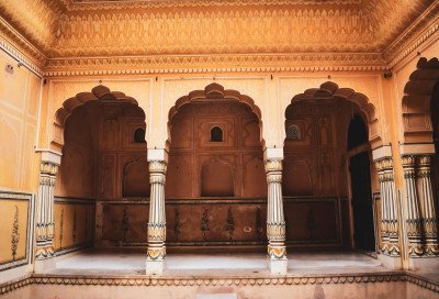
Raja's Fort Ruins
Some quick example text to build on the card title and make up the bulk of the card's content.
Go somewhere
Shanti Sagara Lake
Some quick example text to build on the card title and make up the bulk of the card's content.
Go somewhere
Shiv Sagar Lake
Some quick example text to build on the card title and make up the bulk of the card's content.
Go somewherein Other Cities