
Tilaitanr Dam
General information
-
Ideal Duration:
2 to 3 hours (Ideal for a peaceful visit, including travel from Ghatsila and photography time)Place Type:
Dam and Reservoir, Nature/Scenic Spot, Picnic SpotEntry Fees:
Nominal Fees: Generally, there is No Entry Fee to access the Tilaitanr Dam area itself, as it is primarily a piece of public water infrastructure and a natural attraction. Unlike commercially developed tourist centers, most local dams maintain open access.Nominal Fees: Generally, there is No Entry Fee to access the Tilaitanr Dam area itself, as it is primarily a piece of public water infrastructure and a natural attraction. Unlike commercially developed tourist centers, most local dams maintain open access.
Parking Charges: In the peak Winter picnic season (especially during December and January), local authorities or youth clubs may set up temporary stands to collect a nominal fee for vehicle parking. This fee is usually very small, typically ranging from Rs.10 to Rs.30 per vehicle, and is used for local maintenance or organizing temporary facilities.
Guide/Local Service Fees: While not mandatory, if a visitor hires a local person to act as a guide for a trek to a specific hidden spot or for birdwatching assistance, a fee would be paid directly to that individual. There is no formal ticketing system. Visitors should be wary of any unofficial collection of large sums of money.
Photography and Videography: There are no specific charges for personal photography or videography. However, for commercial filming or professional large-scale shoots, formal permission from the local administration or the irrigation department overseeing the dam might be required, which could involve a substantial fee. The spirit of the place is free access to nature.Timing:
Regular Timings: The Tilaitanr Dam is essentially a natural, open-air spot and does not have official opening or closing hours. It is accessible from Sunrise to Sunset. It is strongly recommended to visit only during daylight hours, generally from 6:00 AM to 5:30 PM. Nigh...Regular Timings: The Tilaitanr Dam is essentially a natural, open-air spot and does not have official opening or closing hours. It is accessible from Sunrise to Sunset. It is strongly recommended to visit only during daylight hours, generally from 6:00 AM to 5:30 PM. Night visits are highly discouraged due to a lack of lighting, security, and the presence of wildlife.
Ideal Visit Time: The absolute Ideal Visit Time is in the early morning, around 7:00 AM to 9:00 AM, for the best light for photography, the coolest temperature, and the maximum opportunity for birdwatching and enjoying the true tranquility before local visitors arrive. The second-best time is the late afternoon, from 3:30 PM to 5:30 PM, to witness the breathtaking Sunset.
Time for Picnickers: Picnickers tend to arrive between 10:00 AM and 11:00 AM and stay until 4:00 PM, especially on weekends and holidays in Winter. If you prefer solitude, avoid this window.
Safety Considerations for Timings: Always plan to leave the area well before Sunset to ensure a safe drive back, as the local roads can be unlit and sparsely populated after dark.Special Events:
Local Festivals and Rituals: The Tilaitanr Dam area, being close to the local village of Bhatin, often becomes a focal point for certain local rituals and festivals, particularly those related to water, nature, and the harvest cycle. For example, during Makar Sankranti in J...Local Festivals and Rituals: The Tilaitanr Dam area, being close to the local village of Bhatin, often becomes a focal point for certain local rituals and festivals, particularly those related to water, nature, and the harvest cycle. For example, during Makar Sankranti in January, or local harvest festivals like Tusu Parab, the banks of the reservoir might witness smaller, traditional gatherings, folk songs, and simple fairs organized by the local community.
Chhath Puja Celebrations: One of the most significant regional events is Chhath Puja (usually in October or November). Though not the biggest venue, the reservoir banks are used by local devotees to perform the sacred rituals of offering prayers to the Sun God at Sunrise and Sunset. Witnessing this deeply spiritual and visually captivating event provides a rich cultural experience.
Picnic Season Rush: While not a 'special event' in the religious sense, the peak picnic season, typically from November to February, transforms the site into a hub of joyous activity, especially on New Year's Day. The atmosphere is festive with groups enjoying food, music, and games, which in itself is a special, vibrant experience unique to the Winter season in this part of India. These events offer a chance to observe the local culture and community spirit.Best Photo Spots:
The Dam Crest Viewpoint: The top of the dam wall (the crest) offers a panoramic and unobstructed view. This is the best spot for wide-angle landscape shots, capturing the entire expanse of the reservoir on one side and the downstream valley/spillway on the other. It’s pe...The Dam Crest Viewpoint: The top of the dam wall (the crest) offers a panoramic and unobstructed view. This is the best spot for wide-angle landscape shots, capturing the entire expanse of the reservoir on one side and the downstream valley/spillway on the other. It’s perfect for capturing the dramatic Sunset or Sunrise colors reflecting on the water.
Secluded Shoreline Patches: For intimate nature and reflection photography, explore the edges of the lake where the water meets the shore, especially where trees or rocks frame the view. This is ideal for capturing close-up reflections and the quiet texture of the water surface. Look for spots where overhanging branches create a natural frame.
The Approach Road Through the Greens: The road or path leading up to the dam, especially if lined by dense Sal trees or flanked by small hillocks, is a great spot for travel and mood photography. It can be used to frame the dam or the surrounding hills in the distance, emphasizing the journey to the tranquil spot.
Birdwatching Perches: Locate areas where the local birds congregate, such as low-hanging branches near the water or reedy patches. These spots allow for excellent telephoto shots of the avian life in their natural habitat, requiring patience and a respectful distance.
The Spillway or Outlet Channel: If the spillway is flowing, the downstream area where the water is released can offer dynamic and interesting compositions, focusing on the movement of water and the engineering structure in a natural environment.Photo Gallery
Things To Do
-
Nature Photography and Landscape Capture: This is arguably the most popular activity. Focus on capturing the vastness of the reservoir, the reflection of the clouds and hills on the water, and the dramatic light during Sunrise or Sunset. Experiment with long-exposure shots of the water surface and close-ups of the surrounding flora and small wildlife.
Picnicking and Day Outing: Pack a meal and spend a few relaxing hours on the grassy banks of the reservoir. The calm environment is perfect for a family picnic or a group gathering. Ensure all trash is collected and taken back to maintain the spot's pristine condition.
Leisurely Walks and Gentle Trekking: Explore the walking trails that go around the dam's perimeter or along the water's edge. These are generally easy walks suitable for all age ...
Information
-
Why Famous:
The Beauty of Tranquility: The primary fame of Tilaitanr Dam is its exceptional natural beauty and the atmosphere of peace and quiet it offers, setting it apart from more crowded tourist spots. It is not as commercially famous as the nearby Burudi Dam but is cherished by th...The Beauty of Tranquility: The primary fame of Tilaitanr Dam is its exceptional natural beauty and the atmosphere of peace and quiet it offers, setting it apart from more crowded tourist spots. It is not as commercially famous as the nearby Burudi Dam but is cherished by those who prefer seclusion. The large water body, created by the damming of a local river or stream, forms a vast, serene lake surrounded by gentle hills and dense greenery, offering breathtaking, uninterrupted views. The clear water and the reflections of the sky and hills are especially famous among photographers and nature lovers.
An Offbeat Picnic Destination: The dam and its periphery have become a popular, albeit locally known, picnic spot, particularly during the cooler Winter months. Families and groups from Ghatsila and nearby towns frequent the spot for day outings, utilizing the spacious, natural setting for relaxation and recreation. Its fame stems from being a clean, unspoiled location where one can truly connect with nature without the typical noise and commercialization found at major tourist hubs.
Photographer's Delight: The location is famous for its stunning light conditions, particularly during the early morning and late afternoon hours. The golden light during Sunrise and Sunset casts long shadows and bathes the reservoir in warm colors, making it an exceptional location for landscape photography. The interplay of water, hills, and sky creates a dynamic and beautiful canvas that is highly prized by local and visiting photo enthusiasts. -
Architecture:
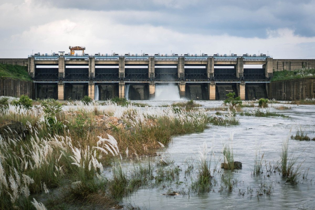
Dam Structure and Purpose: The Tilaitanr Dam is generally an earthen or rock-fill dam, typical of smaller water retention structures built in hilly or undulating terrain. Unlike large concrete gravity dams, this dam's architecture focuses on forming a robust barrier using l...Dam Structure and Purpose: The Tilaitanr Dam is generally an earthen or rock-fill dam, typical of smaller water retention structures built in hilly or undulating terrain. Unlike large concrete gravity dams, this dam's architecture focuses on forming a robust barrier using locally sourced materials, ensuring stability against the water pressure while blending with the natural environment. The primary function is water storage for irrigation and potentially local drinking water supply, rather than large-scale power generation.
Materials and Construction: The main body of the dam wall is typically composed of compacted earth, clay, and rock fill, which are locally abundant in the East Singhbhum area. This type of construction allows for flexibility and is cost-effective for a local project. The upstream face (the side facing the water) is often protected by a layer of rock, known as riprap, to prevent erosion from wave action. The crest, or top, of the dam usually serves as a pathway for maintenance.
Water Control Mechanisms and Dimensions: The dam structure includes a spillway mechanism, often a simple uncontrolled weir or a gated structure, to safely release excess water during heavy rainfall, preventing the dam from being overtopped. While the precise dimensions are not public knowledge like major projects, based on its classification as a local dam near Ghatsila, the dam wall is likely in the range of a few hundred meters in length. The height is moderate, perhaps between 10 to 15 meters, creating a reservoir that spreads out to cover a few square kilometers, providing the scenic lake-like appearance. The design prioritizes simplicity and function, adhering to standard engineering principles for small to medium-sized water reservoirs.
Impact on Landscape: The structure is an example of hydraulic engineering adapting to the local geography, using the valley's natural contours to maximize water retention with minimal structural intervention. -
How To Reach:
By Air: The nearest major airport is Birsa Munda Airport (IXR) in Ranchi, approximately 150 KMS away from Ghatsila. The second nearest is Netaji Subhas Chandra Bose International Airport (CCU) in Kolkata, about 240 KMS away. From either airport, you would need to hire a pr... -
Near Tourist Places:
Burudi Dam: (Approx.
15 KMS), Phuldungri Hillock: (Approx.
12 KMS), Bibhuti Bhushan Bandopadhyay's Cottage: (Approx.
10 KMS), Rankini Mandir: (Approx.
15 KMS), Galudih Barrage: (Approx.
30 KMS), Dharagiri Falls: (Approx.
25 KMS), Pancha Pandav Hills: (Approx.
15 KMS), Ratmohona: (Approx.
25 KMS), Jadugoda Mines Area: (Approx.
5 KMS), Narwa Forest: (Approx. 15 KMS)
Tourism Tips
-
Health and Safety: Carry a basic First-Aid Kit for minor cuts, insect bites, and headaches. Since the dam is a large water body, exercise extreme caution near the water's edge, especially with children. Swimming is strictly discouraged as the depth and undercurrents can be...
Reviews
Ghatsila Itineray And Cost:-
Information about New and Updated Locations() of Jharkhand Has Been Added :-
Card subtitle
Note:-
Information provided here in good Faith and for reference only.
All information and pictures will be updated soon, please keep visiting.
Near Places
Amadubi Rural Tourism Village
Some quick example text to build on the card title and make up the bulk of the card's content.
Go somewhere
Benasol Falls
Some quick example text to build on the card title and make up the bulk of the card's content.
Go somewhere
Bibhutibhushan Bandyopadhyay's Cottage
Some quick example text to build on the card title and make up the bulk of the card's content.
Go somewhere
Birsa Fun City Waterpark
Some quick example text to build on the card title and make up the bulk of the card's content.
Go somewhere
Burudih Lake/Dam
Some quick example text to build on the card title and make up the bulk of the card's content.
Go somewhere
Chatra Waterfalls
Some quick example text to build on the card title and make up the bulk of the card's content.
Go somewhere
Dharagiri Falls
Some quick example text to build on the card title and make up the bulk of the card's content.
Go somewhere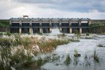
Galudih Barrage/Dam
Some quick example text to build on the card title and make up the bulk of the card's content.
Go somewhere
Gouri Kunj
Some quick example text to build on the card title and make up the bulk of the card's content.
Go somewhere
Jadugoda Mines Area
Some quick example text to build on the card title and make up the bulk of the card's content.
Go somewherein Other Cities