


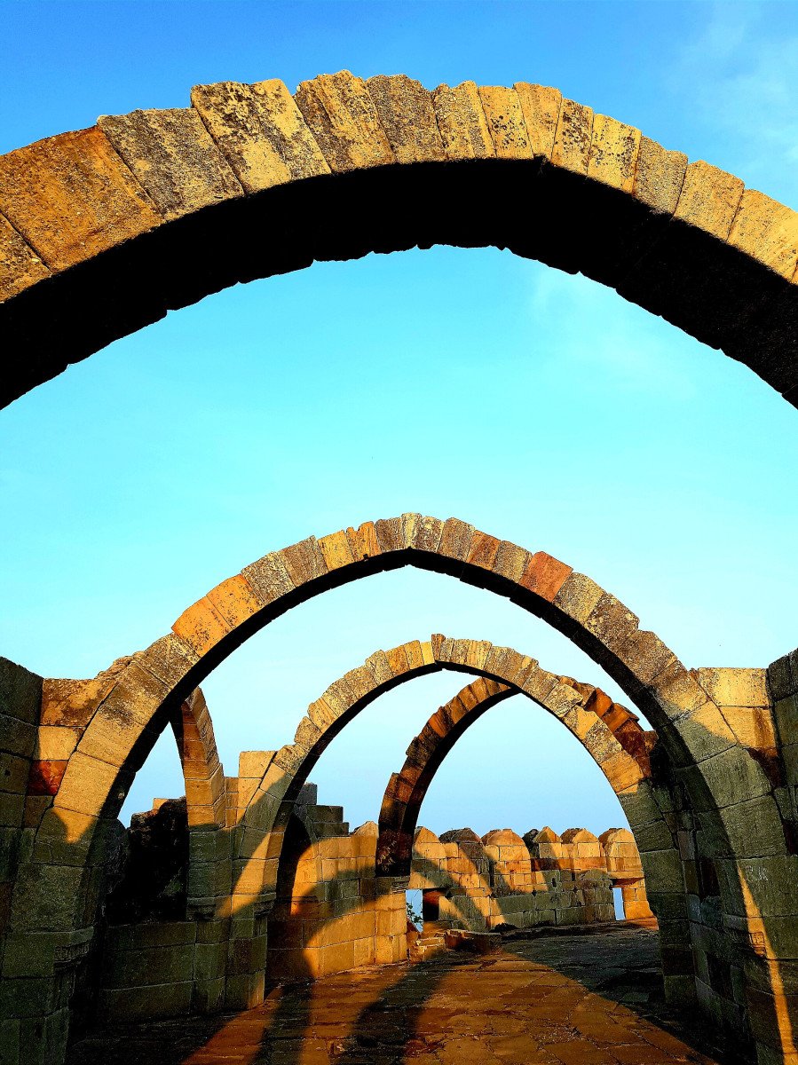
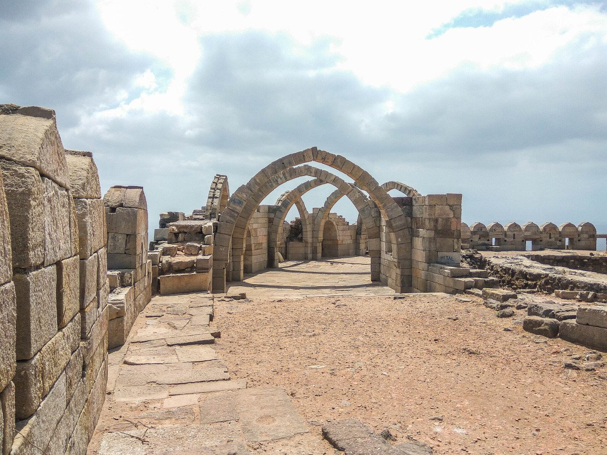
Saat Kaman
General information
-
Ideal Duration:
45 MinutesPlace Type:
Scenic Landmark:: Military Lookout and ViewpoiEntry Fees:
No Direct Entry Fee:: As an open ruin/viewpoint on the public path, there is no direct entry fee.
ASI/Park Entry Fee may apply:: The standard ASI entrance fee (charged for entry into the fort area) will apply, as the Saat Kaman is located de...No Direct Entry Fee:: As an open ruin/viewpoint on the public path, there is no direct entry fee.
ASI/Park Entry Fee may apply:: The standard ASI entrance fee (charged for entry into the fort area) will apply, as the Saat Kaman is located deep within the middle/upper fort's fortified area. The fee is nominal (INR 40 for Indians) and provides access to the cluster of ruins on the hill.Timing:
Regular Timings: Open Sunrise to Sunset (approx. 6:00 AM to 6:00 PM).
Ideal Visit Time: Late afternoon, around 4:00 PM to 6:00 PM, to catch the incredible sunset view and benefit from the cooler evening temperature.
Read MoreRegular Timings: Open Sunrise to Sunset (approx. 6:00 AM to 6:00 PM).
Ideal Visit Time: Late afternoon, around 4:00 PM to 6:00 PM, to catch the incredible sunset view and benefit from the cooler evening temperature.
Avoid: Mid-day, as the open structure offers limited shade.Special Events:
Sunset Photography Meetups:: Local photography clubs and travel enthusiasts often organize informal meetups at the Saat Kaman to capture the magnificent sunset views over the plains, especially during the clear Winter months, creating a vibrant, social atmosphere. ...Sunset Photography Meetups:: Local photography clubs and travel enthusiasts often organize informal meetups at the Saat Kaman to capture the magnificent sunset views over the plains, especially during the clear Winter months, creating a vibrant, social atmosphere.Best Photo Spots:
The Archway Repetition:: A photograph that captures the linear repetition of the arches, providing a strong sense of perspective and depth, especially when looking down the line of the structure.
The Cliff-Edge View:: A shot taken from the s...The Archway Repetition:: A photograph that captures the linear repetition of the arches, providing a strong sense of perspective and depth, especially when looking down the line of the structure.
The Cliff-Edge View:: A shot taken from the side of the arches, capturing the structure clinging dramatically to the edge of the steep cliff, emphasizing the danger and strategic positioning.
Foreground Framing with Ruins:: Use the broken stone remnants near the arches as foreground elements to add texture and historical context to the panoramic shots of the valley.Photo Gallery
Things To Do
-
Photography and Landscape::
Archway Framing: Capture the vast landscape or a person framed within one of the majestic arches.
Sunset View: The arches provide the most spectacular spot for watching the sun set over the Champaner plains.
Historical Reflection: Imagine the military watchmen guarding the approaches from this high vantage point.
Rest and Hydration: Stop here for a break on the strenuous climb/descent, utilizing the natural shade of the arches.
Nature Appreciation: Use the elevated position to observe the different layers of the forest and the distant agricultural patterns on the plains.
Study of Stone Arches: Observe the structural integrity and the te...
Information
-
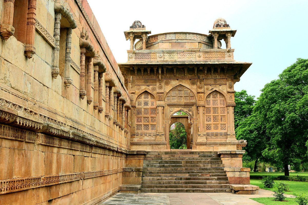
Why Famous:
Panoramic View and Architectural Icon:: The Saat Kaman is most famous for offering the best panoramic views of the Champaner-Pavagadh Archaeological Park. The sight of the ruins and the plains framed by the ancient arches is a highly sought-after photographic opportunity, m...Panoramic View and Architectural Icon:: The Saat Kaman is most famous for offering the best panoramic views of the Champaner-Pavagadh Archaeological Park. The sight of the ruins and the plains framed by the ancient arches is a highly sought-after photographic opportunity, making it a well-known landmark. It is famous for its name, "Seven Arches," which has acquired a legendary status, inspiring local folklore about the structure's origins. Strategically, its fame rests on its role as a key lookout point for the defense of the hill, giving visitors a chance to stand in the exact spot where medieval guards watched for approaching armies. It is one of the few places on the hill where the sheer drop and the expansive view truly make one appreciate the military genius of the fort's location. The structure is often featured on postcards and travel guides, symbolizing the grandeur of Pavagadh. -
Architecture:
Arch-Based Fortification Style:: The Saat Kaman is a prime example of Indo-Islamic military architecture, utilizing the arch as the core structural element. It is built using local, sturdy, reddish-yellow sandstone blocks. The design focuses on robust support and open visi...Arch-Based Fortification Style:: The Saat Kaman is a prime example of Indo-Islamic military architecture, utilizing the arch as the core structural element. It is built using local, sturdy, reddish-yellow sandstone blocks. The design focuses on robust support and open visibility.
Dimension and Form:: The structure is essentially a long, arched gallery. The surviving arches are tall and well-proportioned, typically spanning 10 to 15 feet each. The entire length of the arched structure is significant, possibly over 100 feet long, strategically following the cliff edge. The arches are simple, slightly pointed, and built without excessive ornamentation, emphasizing their functional and defensive purpose as a line of sight and fire control. The stone blocks used are massive, underscoring the permanence and military intent of the structure. -
How To Reach:
By Ropeway and Walk:: Reach the Machi plateau, take the ropeway to the mid-level station, and then walk for approximately 15-20 minutes uphill along the main path. The Saat Kaman is a prominent structure on the edge of the path.
By Foot (Trekki... -
Near Tourist Places:
Navlakha Kothar (0.
2 km):: Jain Temples (Bavanderi/Navalakha) (0.
5 km):: Lakulisa Temple (Mauliya Plateau) (0.
5 km)::
Pavagadh Fort Walls (immediate vicinity)::
Kalika Mata Temple (2 km - uphill):: Doodhiya Talav (1.
5 km - descent)::
Khuniya Mahadev Waterfall (4 km - descent):: Machi Plateau (Ropeway Base) (1.
5 km - walk/ropeway)::
Vada Talav Lake (Visible in the distance -
5 km)::
Champaner City Ruins (7 km - descent)::
Tourism Tips
-
Health & Safety:
Cliff Danger:: The Saat Kaman is located right on the edge of a sheer cliff. There are no guardrails. Exercise extreme caution, especially with children, and do not attempt to climb on the arches.
Read More
Reviews
Information about New and Updated Locations(862+) of Gujarat Has Been Added :-
Card subtitle
Note:-
Information provided here in good Faith and for reference only.
All information and pictures will be updated soon, please keep visiting.
Near Places
Atak Gate
Some quick example text to build on the card title and make up the bulk of the card's content.
Go somewhere
Champaner-Pavagadh Archaeological Park
Some quick example text to build on the card title and make up the bulk of the card's content.
Go somewhere
Dudhiya Lake
Some quick example text to build on the card title and make up the bulk of the card's content.
Go somewhere
Hathni Mata Waterfall
Some quick example text to build on the card title and make up the bulk of the card's content.
Go somewhere
Jain Temples
Some quick example text to build on the card title and make up the bulk of the card's content.
Go somewhere
Jambughoda Wildlife Sanctuary
Some quick example text to build on the card title and make up the bulk of the card's content.
Go somewhere
Jami Masjid
Some quick example text to build on the card title and make up the bulk of the card's content.
Go somewhere
Kalika Mata Temple
Some quick example text to build on the card title and make up the bulk of the card's content.
Go somewhere
Kevada Masjid
Some quick example text to build on the card title and make up the bulk of the card's content.
Go somewhere
Khuniya Mahadev Waterfall
Some quick example text to build on the card title and make up the bulk of the card's content.
Go somewherein Other Cities