

Bindu
General information
-
Ideal Duration:
Half-Day Trip (From Jhalong or Samsing) or a 1-day stay for deep immersion.Place Type:
Border Village, Hydropower Site, and Scenic RiverEntry Fees:
General Village Access and Dam Viewing (No Charge): There is fundamentally no entry fee to visit the village of Bindu or to access the main public river viewing areas near the dam.
Free Access to Public Areas and Scenic Spots: The area oper...General Village Access and Dam Viewing (No Charge): There is fundamentally no entry fee to visit the village of Bindu or to access the main public river viewing areas near the dam.
Free Access to Public Areas and Scenic Spots: The area operates as an open village settlement, and scenic viewing is considered a right of public access, making it very accessible for budget travelers.
Potential Vehicle and Parking Fees: A minor, localized fee might be charged by local youth committees for parking vehicles in designated spots near the dam area. Local Infrastructure Contribution and Vehicle Regulation: This charge is usually nominal, typically between Rs.50 and Rs.100, and is used to maintain cleanliness and basic facilities in the highly frequented tourist areas, particularly during the peak Winter season. Photography/Videography Fees (Official Permit Requirement): While casual photography with a mobile phone or simple camera is free, professional or commercial photography/videography requires explicit permission and payment of a fee to the relevant local authorities or the CISF. Commercial Use Restriction and Official Permit Costs: This is strictly enforced due to the sensitive nature of the dam and border infrastructure. Tourists must inquire locally if their equipment is deemed "professional" and what the associated permit costs are.Timing:
Regular Daytime Access Timings (Security and Safety): Bindu is generally accessible to tourists during daylight hours, typically from 8:00 AM to 5:30 PM.
Restricted Access to Sensitive Areas: Although the village itself is always open, the approach road to the dam ...Regular Daytime Access Timings (Security and Safety): Bindu is generally accessible to tourists during daylight hours, typically from 8:00 AM to 5:30 PM.
Restricted Access to Sensitive Areas: Although the village itself is always open, the approach road to the dam viewing points is controlled by security forces, who restrict movement late in the evening and at night for safety and security reasons concerning the international border.
Ideal Visit Time (Peak River Volume and Lighting): The best time to arrive for viewing and photography is in the early morning, around 9:00 AM, when the sun clears the hills, or in the late afternoon, around 3:30 PM.
Morning Light and Post-Monsoon River Flow: Post-monsoon (late September to November) is ideal for maximizing the spectacular volume of water flowing through the dam, which is the site's most impressive feature.Special Events:
Annual Indigenous Harvest Festivals: The communities around Bindu often celebrate traditional harvest festivals, particularly after the paddy harvest in October or the citrus harvest in December. Seasonal Cultural Celebrations and Community Dance: These informal gatherings...Annual Indigenous Harvest Festivals: The communities around Bindu often celebrate traditional harvest festivals, particularly after the paddy harvest in October or the citrus harvest in December. Seasonal Cultural Celebrations and Community Dance: These informal gatherings are deeply rooted in Nepali and local tribal traditions, featuring traditional musical instruments, colorful folk dances, and communal feasting. Tourists staying at nearby homestays or resorts may be invited to witness or respectfully participate in these authentic cultural events, which celebrate the bounty of the valley.Best Photo Spots:
The Jaldhaka Dam View from the Bridge:
Water, Structure, and Forest Composition: Stand on the vantage point near the bridge (respecting security restrictions) to capture the wide, powerful flow of the Jaldhaka River as it hits the dam wall. ...The Jaldhaka Dam View from the Bridge:
Water, Structure, and Forest Composition: Stand on the vantage point near the bridge (respecting security restrictions) to capture the wide, powerful flow of the Jaldhaka River as it hits the dam wall. Use the long, horizontal line of the dam to divide the rushing water in the foreground from the rising, dense forest of Bhutan in the background, emphasizing the scale of the structure and the wildness of the landscape.
The Border Pillar and River Landscape:
Geopolitical Context and Natural Boundary: Focus on the official border marker (if visible and permitted) or simply the point where the river clearly marks the international boundary. Frame the shot with the river in the foreground, using the forested hills of the foreign country in the background to add a sense of intrigue and travel, capturing the unique feel of a final frontier.
Winter Orange Orchards and Cardamom Terraces:
Agricultural Contrast and Seasonal Color: During the Winter months, capture the bright, luminous orange fruits hanging heavily from the trees near the village, contrasted against the deep green foliage. For the cardamom plantations, focus on the low-level terraces and the unique texture of the large, shady leaves that define this special hill crop.Photo Gallery
Things To Do
-
Visiting the Jaldhaka Dam and River Viewpoint (Photography and Observation): The central activity is observing the Jaldhaka Dam from the designated public viewpoints.
Water Engineering and Himalayan River Power: Spend time appreciating the flow of the river, which originates in Bhutan, as it enters India and is harnessed by the hydroelectric project. It is crucial to stay within the marked safety areas and respect the security personnel while taking photographs of the wide river, the dam wall, and the forested slopes on the Bhutan side. Border Photography at the International River Line (Geopolitical Experience): Walk along the riverbank path that clearly delineates the border with Bhutan (the river itself).
Experiencing the Indo-Bhutan Frontier: Capture photographs with the hills of Bhutan forming the backdrop acros...
Hotels
● Deki Lodge
Address: Bindu, Dooars, West Bengal
Distance: 1 KM
Details: Budget-friendly lodge with essential facilities. Clean and basic, perfect for a short stay before proceeding further into the hills....
● Grey Dove Homestay
Address: Bindu, Dooars, West Bengal
Distance: 2 KM
Details: Affordable and peaceful homestay. Well-maintained rooms, garden area, and helpful hosts make it a comfortable stay for visitors looking for nature....
● Malabika Homestay
Address: Bindu, Dooars, West Bengal
Distance: 1 KM
Details: A cozy homestay offering authentic local culture. Simple, clean rooms with home-cooked meals provide a genuine experience for mid-range budget travele...
● Norma Homestay
Address: Bindu, Dooars, West Bengal
Distance: 1 KM
Details: Warm and welcoming homestay experience. Includes breakfast and local sightseeing assistance. Excellent for families and small groups wanting a homely ...
● Poddar Retreat
Address: Bindu, Dooars, West Bengal
Distance: 2 KM
Details: One of the most budget-friendly options in the area. Simple rooms with shared amenities, best for backpackers and students....
● Rio De Vallis Eco Resort
Address: Bindu, Dooars, West Bengal
Distance: 3 KM
Details: An eco-friendly resort focused on nature. Offers sustainable luxury with comfortable rooms, organic food, and guided nature walks around Bindu....
● Sherpas Enclave
Address: Bindu, Dooars, West Bengal
Distance: 1 KM
Details: Simple, clean guest house with a peaceful environment. Offers basic amenities at a low cost, making it ideal for budget travelers....
● Summit Norling Resort & Spa
Address: Kalimpong (Near Bindu)
Distance: 35 KM
Details: Luxury resort offering elite amenities including a world-class spa and swimming pool. Perfect for travelers seeking premium comfort and relaxation....
● The Elgin Silver Oaks
Address: Kalimpong (Near Bindu)
Distance: 38 KM
Details: Historic luxury hotel with vintage charm. Features plush interiors, fine dining, and personalized services for a truly grand experience....
● Udaan Alpine Resort
Address: Bindu, Dooars, West Bengal
Distance: 2 KM
Details: Luxury stay with stunning views of the hills. Features include an on-site spa, restaurant, and premium rooms with mountain views for a relaxing retrea...
Show AllRestaurants
● Bindu Eco Hut Cafe
Address: Near Dam View, Bindu, West Bengal
Distance: 4 KM
Details: Bindu Eco Hut Cafe offers a sustainable and cozy dining environment. It is a charming place to visit in November. The cafe focuses on local, seasonal ...
Food List: 'Herbal Tea', 'Papad', 'Biscuits', 'Juice', 'Coffe...
● Bindu Valley Restaurant
Address: Bindu Point, Dooars, West Bengal
Distance: 1 KM
Details: Bindu Valley Restaurant captures the essence of Bindu with its stunning location and authentic food. It is a top choice in August as the lush green va...
Food List: 'Nepali Thali', 'Sel Roti', 'Dal', 'Sabzi', 'Achar...
● Borderline Inn
Address: Border Road, Bindu, West Bengal
Distance: 9 KM
Details: Borderline Inn is strategically located near the border, offering a unique experience. It is a popular destination in April. The menu includes a blend...
Food List: 'Biryani', 'Raita', 'Salad', 'Dal', 'Pickle'...
● Cardamom Retreat Dining
Address: Cardamom Road, Bindu, India
Distance: 2 KM
Details: Cardamom Retreat Dining is an elegant restaurant nestled in the heart of the cardamom plantations of Bindu. It is a peaceful destination in September,...
Food List: 'Spiced Chicken', 'Pulao', 'Raita', 'Dal', 'Salad'...
● Green Valley Cafe
Address: Near Power Plant, Bindu
Distance: 8 KM
Details: Green Valley Cafe is a bright and cheerful spot, perfect for a casual meal. It is a fantastic place in March as the valley turns vibrant green. The ca...
Food List: 'Cheese Sandwich', 'Fresh Fruit Juice', 'Tea', 'Co...
Show AllInformation
-
Why Famous:
Strategic Location on the Indo-Bhutan Border: Bindu is famous primarily for being the final point of entry and the site of the actual physical border crossing (for the river) with the Kingdom of Bhutan. Geopolitical Significance and International Boundary Marker: Visitors ...Strategic Location on the Indo-Bhutan Border: Bindu is famous primarily for being the final point of entry and the site of the actual physical border crossing (for the river) with the Kingdom of Bhutan. Geopolitical Significance and International Boundary Marker: Visitors are drawn by the novelty of standing so close to a foreign country, separated only by the rushing Jaldhaka River. The border pillar and the presence of security forces reinforce its status as a unique geopolitical vantage point in the region.
The Scenic Jaldhaka Dam and River Confluence: Its second claim to fame is the impressive structure of the Jaldhaka Dam and the serene beauty of the wide river valley.
Engineering Marvel in a Natural Setting: The dam symbolizes human achievement in harnessing nature's power, set against a stunning backdrop of unpolluted Himalayan forests. The site is aesthetically pleasing, with the massive water body and the surrounding lush greenery creating a tranquil, photographic landscape highly valued by tourists. -
Architecture:
The Jaldhaka Dam Hydroelectric Structure: The centerpiece of Bindu is the functional infrastructure related to the hydroelectric project.
Functional Engineering and Structural Dimensions: The Jaldhaka Dam is a gravity structure, built to wi...The Jaldhaka Dam Hydroelectric Structure: The centerpiece of Bindu is the functional infrastructure related to the hydroelectric project.
Functional Engineering and Structural Dimensions: The Jaldhaka Dam is a gravity structure, built to withstand the immense hydrostatic pressure of the river. While the exact dimensions are restricted due to its strategic nature, the main weir structure is substantial, estimated to be around 100 meters long and several stories high. The construction uses heavy-duty, reinforced concrete, designed for durability against the harsh climate and the powerful river current. The architecture is purely utilitarian, focused on generating power and diverting water, with a long, reinforced bridge connecting the two sides of the valley, offering a commanding view of the river course.
Indigenous Hillside Village Housing: The nearby village homes reflect the practicalities of hill life and local climate.
Climate-Adapted Housing and Material Use: Houses are traditionally built with thick stone foundations to cope with the steep slopes and damp soil, utilizing locally sourced slate or corrugated tin for the roofs, which are steeply pitched to efficiently shed the heavy monsoon rainfall. The typical house size is compact, often about 10 meters by 7 meters, generally featuring a simple, open veranda. Newer structures incorporate concrete but maintain the functional design of elevation and sturdy construction to withstand tremors and climatic extremes. -
How To Reach:
By Air: The closest airport is Bagdogra Airport (IXB) near Siliguri.
Initial Air Journey and Reliance on Taxi Hire: Bindu is approximately 115 KMS from the airport. There are no public transport links directly from the airport, so a privat... -
Near Tourist Places:
Jhalong: 10 KMS (Hydroelectric Dam site and main market)
Paren: 15 KMS (Quiet forest village and resort)
Samsing: 25 KMS (Tea gardens and river picnic spot)
Suntalekhola: 29 KMS (Secluded forest resort)
Gorumara National Park: 45 KMS (Wildlife safari for Rhino and Gaur)
Chapramari Wildlife Sanctuary: 40 KMS (Elephant sightings)
Chalsa: 30 KMS (Major road junction)
Malbazar: 40 KMS (Nearest major town with railway station)
Lava: 75 KMS (Higher altitude hill station)
Lolegaon: 90 KMS (Canopy walk destination)
Tourism Tips
-
Health & Safety (Security Zone Rules and River Safety): Strict Adherence to Security Directives and Water Caution: Since Bindu is a border area and a security-sensitive dam site, visitors must strictly follow all instructions given by the CISF and local police. Never attempt to cross the river or ...
Reviews
Dooars Itineray And Cost:-
Information about New and Updated Locations() of West Bengal Has Been Added :-
Card subtitle
Note:-
Information provided here in good Faith and for reference only.
All information and pictures will be updated soon, please keep visiting.
Near Places

Bhutanghat
Some quick example text to build on the card title and make up the bulk of the card's content.
Go somewhere
Bindu
Some quick example text to build on the card title and make up the bulk of the card's content.
Go somewhere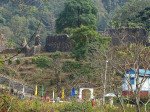
Buxa Fort
Some quick example text to build on the card title and make up the bulk of the card's content.
Go somewhere
Buxa Tiger Reserve
Some quick example text to build on the card title and make up the bulk of the card's content.
Go somewhere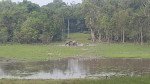
Chapramari Wildlife Sanctuary
Some quick example text to build on the card title and make up the bulk of the card's content.
Go somewhere
Chilapata Forest
Some quick example text to build on the card title and make up the bulk of the card's content.
Go somewhere
Gorumara National Park
Some quick example text to build on the card title and make up the bulk of the card's content.
Go somewhere
Jaldapara National Park
Some quick example text to build on the card title and make up the bulk of the card's content.
Go somewhere
Jayanti
Some quick example text to build on the card title and make up the bulk of the card's content.
Go somewhere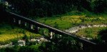
Jhalong
Some quick example text to build on the card title and make up the bulk of the card's content.
Go somewherein Other Cities