

Ghanti Dara View Point
General information
-
Ideal Duration:
45 Minutes (Sufficient for viewing, photography, and short break).Place Type:
Panoramic Ridge Viewpoint, Sunset/Sunrise Spot, anEntry Fees:
Viewpoint Access (Free of Charge): There is no entry fee to access the Ghanti Dara View Point.
Public Highway Access and Natural Attraction: As a naturally occurring viewpoint located directly adjacent to a public highway, the site is desig...Viewpoint Access (Free of Charge): There is no entry fee to access the Ghanti Dara View Point.
Public Highway Access and Natural Attraction: As a naturally occurring viewpoint located directly adjacent to a public highway, the site is designated for unrestricted public access, ensuring that this spectacular 360-degree view remains freely available to all travelers. Roadside Parking and Informal Fees (Voluntary Contribution): Parking is generally free, but during the peak tourist season or when local vendors are operating, a very small, informal fee (often around Rs.10 to Rs.30) may be collected by local youth or community groups. Local Parking Management and Area Cleanliness Fund: This is typically a voluntary contribution intended for basic parking supervision, traffic control, and often for keeping the immediate area clean of litter.Timing:
Regular Timings (24-Hour Access with Caution): The viewpoint is open 24 hours.
Safety Awareness and Night Travel Risks: However, visiting after 5:30 PM is strongly discouraged due to the extreme hazards of navigating steep, narrow mountain ...Regular Timings (24-Hour Access with Caution): The viewpoint is open 24 hours.
Safety Awareness and Night Travel Risks: However, visiting after 5:30 PM is strongly discouraged due to the extreme hazards of navigating steep, narrow mountain roads in the dark and the high winds often experienced at night. Daytime access is highly recommended for safety and visibility.
Ideal Visit Time (Pre-Sunrise or Late Afternoon): The best times are between 5:00 AM and 6:30 AM (for sunrise) or 4:00 PM and 5:30 PM (for sunset).
Optimal Lighting for Photography and Contrast: These specific periods offer the most dramatic, beautiful, and high-contrast light for photography and viewing, as the sun is low on the horizon.Special Events:
Annual Road Rally and Cycling Events (Occasional): The Lava-Lolegaon road is a popular route for organized cycling races, marathon events, and motor vehicle rallies held primarily during the clear season of October or March.
Sports Tourism and ...Annual Road Rally and Cycling Events (Occasional): The Lava-Lolegaon road is a popular route for organized cycling races, marathon events, and motor vehicle rallies held primarily during the clear season of October or March.
Sports Tourism and Spectator Spot: Ghanti Dara often serves as a checkpoint or a prime viewing spot for spectators to watch the participants tackling the challenging mountain terrain, temporarily transforming the quiet spot into a place of cheering and activity. Clear Weather Festivals and Community Gatherings (Informal): During the period of best weather and maximum tourist traffic (e. g. , late October), local communities sometimes organize small, informal melas (fairs) or gatherings near the site to sell handicrafts or local produce to travelers.
Seasonal Commerce and Artisan Display: These temporary markets highlight the seasonal trading activities and provide travelers with a chance to purchase authentic local items right from the people who made them.Best Photo Spots:
High-Angle Panorama of the Winding Road:
Curvature and Depth Perception: Stand slightly elevated or at the far end of the platform and use a wide lens to capture the winding road as it snakes away from the viewpoint, plunging down into the v...High-Angle Panorama of the Winding Road:
Curvature and Depth Perception: Stand slightly elevated or at the far end of the platform and use a wide lens to capture the winding road as it snakes away from the viewpoint, plunging down into the valley. This shot emphasizes the scale of the hill journey and the architectural achievement of the mountain roads.
Silhouette of Visitors Against Sunset:
Contrast and Dramatic Sky Backdrop: During sunset, position yourself to capture the silhouettes of people (or a solitary figure) standing safely on the viewing platform or near the railing. The dark shapes against the intensely colorful, glowing sky create a powerful and emotional visual narrative of human scale against the vast natural canvas.
Isolated Distant Peak Shot:
Telephoto Focus and Peak Detail: Use a telephoto lens (zoom) to isolate a specific distant snow-capped peak, perhaps Kanchenjunga, or a distinctive feature in the valley. The focus here should be on the textural details of the snow and rock, using the clear mountain air to achieve maximum sharpness and contrast.Photo Gallery
Things To Do
-
Capture the 360-Degree Panorama:
Panoramic Photography and Landscape Stitching: Use a panoramic mode on your camera or phone, or take a series of overlapping shots (for later stitching) to capture the full 360-degree view from the ridge. Ensure you include the winding road, the river valley, and the distant peaks in your sequence to fully convey the vastness of the scene.
Identify Distant Mountain Peaks and Rivers:
Geographical Study and Peak Recognition: On a clear day, spend time identifying the prominent snow peaks, including Kanchenjunga, and tracing the path of the Teesta River as it snakes through the gorge below. Use a local guide or map to correctly name the major geographical features visible from this height.
Experience S...
Hotels
● Cerulean Retreat
Address: Lava Bazar, Opp. Forest Office, Kalimpong, West Bengal 734319
Distance: 2.4 KM
Details: Cerulean Retreat is a charming, beautifully designed mid-range lodge offering comfortable stays and excellent views in Lava Bazar. Located very close ...
● Fortune Resort Kalimpong
Address: Ringkingpong Road, Kalimpong, West Bengal 734301
Distance: 18.0 KM
Details: Fortune Resort Kalimpong is an ultra-luxurious heritage resort belonging to the ITC Group, located a short distance from Lava. This world-class proper...
● Hotel Hills View
Address: Lava Bazar, Close to Lava Monastery, Kalimpong, West Bengal 734319
Distance: 2.3 KM
Details: Hotel Hills View is a popular budget hotel situated in Lava Bazar, offering comfortable lodging with stunning mountain views. Known for its close prox...
● Hotel Mahakala
Address: Lava Bazar D.I.F., near Monastery Road, Kalimpong, West Bengal 734319
Distance: 2.2 KM
Details: Hotel Mahakala is a prominent mid-range hotel situated in Lava Bazar, offering highly comfortable rooms and professional service. Known for its conven...
● Lava Swagat Homestay
Address: Lava Bazar Main Road, Kalimpong, West Bengal 734319
Distance: 2.3 KM
Details: Lava Swagat Homestay is an inviting budget-friendly property located close to the heart of Lava Bazar. Highly recommended for family holidays and budg...
● Neoravalley Homestay Lava
Address: Rishop Hill View Trail, near Lava, Kalimpong, West Bengal 734319
Distance: 1.8 KM
Details: Neoravalley Homestay Lava is a well-managed mid-range property offering comfortable and authentic Himalayan lodging near Ghanti Dara. Perfect for trav...
● Rishop - Zivaan Stay
Address: Rishop Village Center, near Ghanti Dara Trail, Kalimpong, West Bengal 734319
Distance: 1.6 KM
Details: Rishop Zivaan Stay is an elegant mid-range mountain resort that provides premium comfort and mesmerizing views of nature. The property features beauti...
● Rishop Mountain Homestay
Address: Rishop Forest Ridge, near Lava, Kalimpong, West Bengal 734319
Distance: 1.5 KM
Details: Rishop Mountain Homestay is a scenic budget property offering a wonderful escape in the peaceful village of Rishop. Surrounded by high pine and birch ...
● Serenity Nest Lava
Address: Lava Bazar D.I.F., Near Hanuman Temple, Kalimpong, West Bengal 734319
Distance: 2.5 KM
Details: Serenity Nest Lava is a beautiful mid-range homestay providing highly rated accommodation in a serene corner of Lava. It is designed to offer peace an...
● WBFDC Lava Nature Resort
Address: Nature Education Resort, Lava, Kalimpong, West Bengal 734319
Distance: 2.1 KM
Details: WBFDC Lava Nature Resort is a premium government-managed eco-tourism resort nestled amidst dense pine and conifer forests. This rustic yet modern prop...
Show AllInformation
-
Why Famous:
The 360-Degree Panoramic View: All-Encompassing Vista and Geographical Comprehension: Ghanti Dara is uniquely famous for offering a genuinely 360-degree view. This allows visitors to simultaneously appreciate the winding river valleys, the dense green forests of the Neora ...The 360-Degree Panoramic View: All-Encompassing Vista and Geographical Comprehension: Ghanti Dara is uniquely famous for offering a genuinely 360-degree view. This allows visitors to simultaneously appreciate the winding river valleys, the dense green forests of the Neora Valley region, and the distant, towering snow peaks of the Himalayas, providing a comprehensive geographical overview of the entire region in one spot.
Sunrise and Sunset Spectacle:
Ideal Lighting and High Contrast Photography: Its ridge-top location means it captures both the first rays of the sun (sunrise) and the last glow of the day (sunset). This high-contrast lighting is perfect for photographers, as the sun directly illuminates the peaks in the east during the morning and casts dramatic, long shadows across the valley in the evening, making it a favorite for travelers on the Lava circuit. -
Architecture:
Exposed Concrete Viewing Platform: The viewpoint utilizes the natural ridge topography for its base.
Utilitarian Hardstanding and Wind Resistance: The main structure is a robust, crescent-shaped concrete hardstanding, designed to provide ma...Exposed Concrete Viewing Platform: The viewpoint utilizes the natural ridge topography for its base.
Utilitarian Hardstanding and Wind Resistance: The main structure is a robust, crescent-shaped concrete hardstanding, designed to provide maximum surface area for visitors without causing erosion on the steep slope. The platform measures approximately 20 meters in length and about 6 meters in width at its widest point, offering ample space for groups and positioning cameras without obstruction.
Safety Railing and Windbreaker Walls: Due to its highly exposed location, safety and visitor comfort against the strong, cold winds are paramount.
Steel Guardrails and Low Parapet Wall: A heavy-duty, twin-bar steel railing system, standing at about 1. 1 meters tall, runs along the entire ridge-facing edge. Additionally, low concrete parapet walls (0. 8 meters high) are often built on the less crucial sides to act as windbreaks, offering slight protection from the strong, continuous gusts that sweep across the open ridge. -
How To Reach:
By Air: The closest airport is Bagdogra Airport (IXB).
Air Gateway to Base and Final Scenic Drive: The distance is approximately 107 KMS. Hire a reserved taxi to Lava. From Lava, hire a local reserved cab for the scenic 12 KMS drive along... -
Near Tourist Places:
Lolegaon: 16 KMS (Canopy walk)
Lava Monastery: 12 KMS (Spiritual center)
Kolakham Village: 18 KMS (Mountain view base)
Lava Viewpoint: 11 KMS (Town viewpoint)
Rishop: 14 KMS (Village viewpoint)
Changey Waterfall: 22 KMS (Scenic falls)
Samabeong Tea Garden: 25 KMS (Tea estate visit)
Ralli: 20 KMS (Small hamlet)
Ghumti: 28 KMS (Scenic bend)
Algarah: 35 KMS (Historic town)
Tourism Tips
-
Health & Safety (Wind and Cold):
Wind Chill Protection and Railing Safety: Wear a windproof jacket and hat, even if the sun is out, as the wind chill at this exposed ridge can be severe. Never climb over the safety railing, as the drop-off ...
Reviews
Lava Itineray And Cost:-
Ghanti Dara View Point Tourism:-
Information about New and Updated Locations() of West Bengal Has Been Added :-
Card subtitle
Note:-
Information provided here in good Faith and for reference only.
All information and pictures will be updated soon, please keep visiting.
Near Places

Changey Waterfall
Some quick example text to build on the card title and make up the bulk of the card's content.
Go somewhere
Ghanti Dara View Point
Some quick example text to build on the card title and make up the bulk of the card's content.
Go somewhere
Kagyu Thekchen Ling Monastery
Some quick example text to build on the card title and make up the bulk of the card's content.
Go somewhere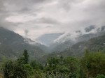
Kolakham Village
Some quick example text to build on the card title and make up the bulk of the card's content.
Go somewhere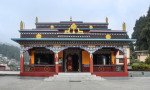
Lava Monastery
Some quick example text to build on the card title and make up the bulk of the card's content.
Go somewhere
Nature Interpretation Centre
Some quick example text to build on the card title and make up the bulk of the card's content.
Go somewhere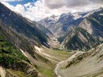
Neora Valley National Park Entry Gate
Some quick example text to build on the card title and make up the bulk of the card's content.
Go somewhere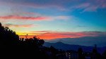
Rishyap
Some quick example text to build on the card title and make up the bulk of the card's content.
Go somewhere
Tiffin Dara Viewpoint
Some quick example text to build on the card title and make up the bulk of the card's content.
Go somewhere
Trek to Neora Valley Core Zone
Some quick example text to build on the card title and make up the bulk of the card's content.
Go somewherein Other Cities