
Lodh Falls
General information
-
Ideal Duration:
3 to 5 Hours :Place Type:
Nature / Adventure :Timing:
Regular Timings: 08:00 AM to 04:30 PM daily. (Entry closes early for safety).
Ideal Visit Time: 09:00 AM to 11:30 AM when the sun illuminates the falls and light is best for photos.
:...Regular Timings: 08:00 AM to 04:30 PM daily. (Entry closes early for safety).
Ideal Visit Time: 09:00 AM to 11:30 AM when the sun illuminates the falls and light is best for photos.
:Special Events:
Picnic Season: Throughout January, the area becomes a lively spot for local families celebrating the New Year.
Forest Conservation Day: Local school groups often visit in March for educational tours and clean-up drives.
Read MorePicnic Season: Throughout January, the area becomes a lively spot for local families celebrating the New Year.
Forest Conservation Day: Local school groups often visit in March for educational tours and clean-up drives.
:Best Photo Spots:
The Lower Bridge: For a full-frame shot of the entire 468-foot drop.
The Stairs: Great for vertical "action" shots of people descending into the mist.
Upstream Rocks: Perfect for capturing the river just be...The Lower Bridge: For a full-frame shot of the entire 468-foot drop.
The Stairs: Great for vertical "action" shots of people descending into the mist.
Upstream Rocks: Perfect for capturing the river just before it makes the big leap.
:Photo Gallery
Things To Do
-
Main Fall Viewing: Stand on the observation deck to feel the mist and hear the roar of the water.
Trekking: Hike the 1 KM forest trail that leads to the upper reaches of the Burha River.
Nature Photography: Capture long-exposure shots of the cascading water for a silky effect.
Birdwatching: Look for the Hill Myna and the Malabar Pied Hornbill in the surrounding canopy.
Visiting Laat Bangla: Explore the ruins of the British-era bungalow located near the entrance.
Picnicking: Set up a camp in the designated areas away from the cliff edge for a forest meal.
Flora Study: Identify the rare ferns and mosses that grow only in the high-humidity zone of the falls.
Information
-
Why Famous:
Highest in the State: Famous for being the highest waterfall in Jharkhand, a title that brings national recognition and pride.
Hydro-Power Potential: It is renowned in geographical studies as a perfect example of a rejuvenated river system ...Highest in the State: Famous for being the highest waterfall in Jharkhand, a title that brings national recognition and pride.
Hydro-Power Potential: It is renowned in geographical studies as a perfect example of a rejuvenated river system forming a massive nick point.
: -
Architecture:
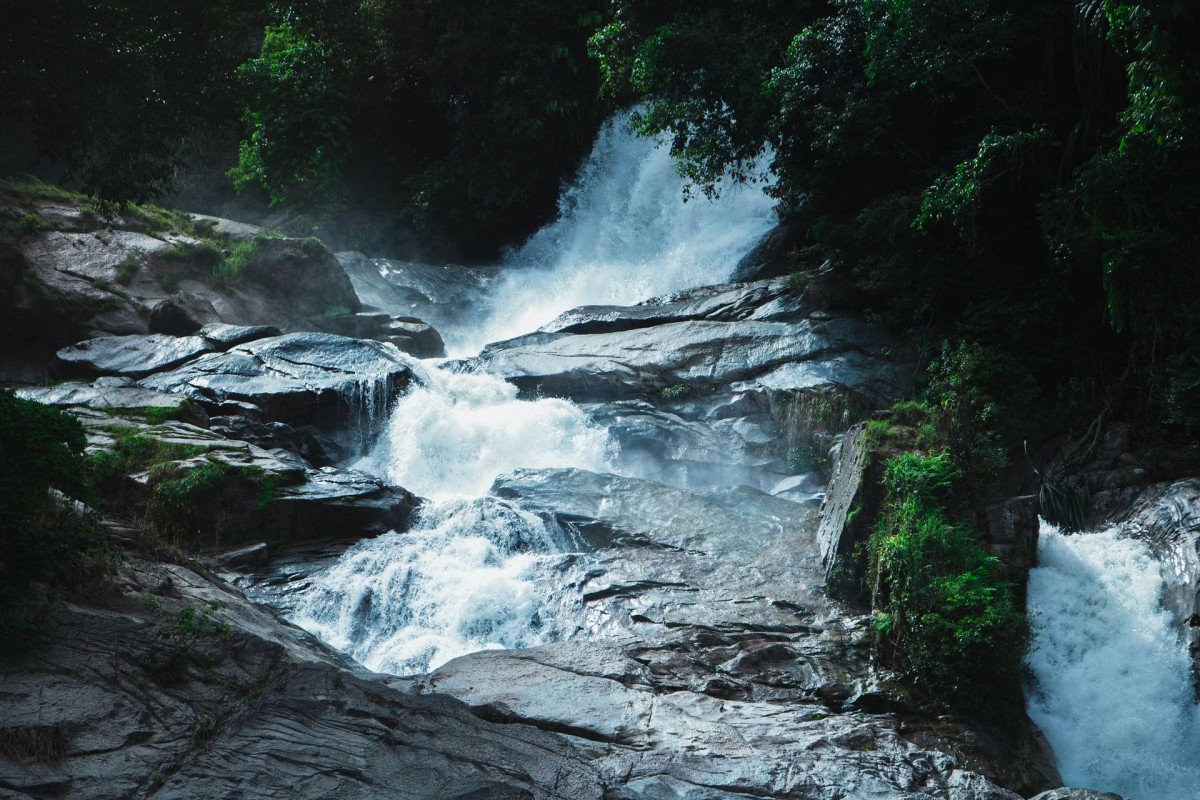
Geological Dimensions: The falls drop from a height of 143 meters (468 ft) and have a width of approximately 30 meters during the peak Monsoon. The base pool covers an area of roughly 2,000 square feet.
Tourist Infrastructure: A series of ...Geological Dimensions: The falls drop from a height of 143 meters (468 ft) and have a width of approximately 30 meters during the peak Monsoon. The base pool covers an area of roughly 2,000 square feet.
Tourist Infrastructure: A series of 163 concrete steps with iron railings has been installed to help tourists descend safely to the viewing area. A circular observation pavilion measuring 400 square feet provides a sheltered view of the main drop.
: -
How To Reach:
By Air: Fly to Ranchi (210 KM) and take a long-distance taxi through Netarhat.
By Train: Reach Daltonganj Railway Station (120 KM) or Latehar (142 KM) and hire a private vehicle.
By Road: Accessible via Mah... -
Near Tourist Places:
Netarhat (61 KM), Magnolia Point (61 KM), Suga Bandh (25 KM), Mirchaiya Fall (30 KM), Betla National Park (95 KM), Palamu Fort (105 KM), Koel View Point (58 KM), Sunrise Point (65 KM), Upper Ghaghri (55 KM), Pear Orchard (54 KM)
Tourism Tips
-
Health and Safety: Strictly avoid swimming in the base pool as the currents are extremely dangerous; stay on the marked paths.
Packing: Carry plenty of drinking water and snacks as there are no shops near the falls.
Read More
Reviews
Latehar Itineray And Cost:-
Information about New and Updated Locations() of Jharkhand Has Been Added :-
Card subtitle
Note:-
Information provided here in good Faith and for reference only.
All information and pictures will be updated soon, please keep visiting.
Near Places
Amdiha Barwadih
Some quick example text to build on the card title and make up the bulk of the card's content.
Go somewhere
Bandanwa Falls
Some quick example text to build on the card title and make up the bulk of the card's content.
Go somewhere
Bendi Dam
Some quick example text to build on the card title and make up the bulk of the card's content.
Go somewhere
Betla National Park
Some quick example text to build on the card title and make up the bulk of the card's content.
Go somewhere
Chhat Talab Mukki
Some quick example text to build on the card title and make up the bulk of the card's content.
Go somewhere
Indra Waterfall
Some quick example text to build on the card title and make up the bulk of the card's content.
Go somewhere
Kamaldah Lake
Some quick example text to build on the card title and make up the bulk of the card's content.
Go somewhere
Kanti Waterfall
Some quick example text to build on the card title and make up the bulk of the card's content.
Go somewhere
Koel River
Some quick example text to build on the card title and make up the bulk of the card's content.
Go somewhere
Kutku Dam Site
Some quick example text to build on the card title and make up the bulk of the card's content.
Go somewherein Other Cities