

Mawsynram
General information
-
Ideal Duration:
1-2 DaysPlace Type:
Adventure & NatureEntry Fees:
Cave Entry: A nominal fee of INR 20 to INR 30 is charged for maintenance and lighting. This is usually managed by a local committee.
Trekking Guides: For exploring nearby caves or fossil parks, guides may charge INR 500 to INR 1000 dependin...Cave Entry: A nominal fee of INR 20 to INR 30 is charged for maintenance and lighting. This is usually managed by a local committee.
Trekking Guides: For exploring nearby caves or fossil parks, guides may charge INR 500 to INR 1000 depending on the duration.Timing:
Regular Timings: Mawjymbuin Cave is open from 8:00 AM to 5:00 PM. The village itself is best explored during daylight hours for safety.
Ideal Visit Time: For the "rainy experience," visit in June or July. For sightseeing and views, the pos...Regular Timings: Mawjymbuin Cave is open from 8:00 AM to 5:00 PM. The village itself is best explored during daylight hours for safety.
Ideal Visit Time: For the "rainy experience," visit in June or July. For sightseeing and views, the post-monsoon months of October and November are best.Special Events:
Wangala Festival: Though a Garo festival, it is celebrated by some communities with 100 drums. It marks the end of the harvest and is a time of great joy and music.
Monsoon Festival: Special events are sometimes organized in June/July to ce...Wangala Festival: Though a Garo festival, it is celebrated by some communities with 100 drums. It marks the end of the harvest and is a time of great joy and music.
Monsoon Festival: Special events are sometimes organized in June/July to celebrate the arrival of the heavy rains, showcasing local crafts and music.Best Photo Spots:
Cave Entrance: The moss-covered rocks at the entrance of Mawjymbuin provide a prehistoric look. The natural light filtering in creates a dramatic effect.
Rolling Green Plateaus: The vast green expanses under a cloudy sky are perfect for wid...Cave Entrance: The moss-covered rocks at the entrance of Mawjymbuin provide a prehistoric look. The natural light filtering in creates a dramatic effect.
Rolling Green Plateaus: The vast green expanses under a cloudy sky are perfect for wide landscape shots. The contrast between the grass and the dark clouds is striking.
Bangladesh Viewpoint: The high cliffs overlooking the plains offer a sense of infinity. Sunset here, if the clouds clear, is a once-in-a-lifetime photo opportunity.Photo Gallery
Things To Do
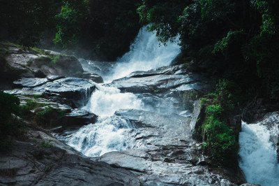 Dainthlen Falls is one of the most powerful and culturally significant waterfalls in Meghalaya. Unlike many falls where you watch from a distance, here you can walk right onto the rocky bed of the river that feeds the plunge. The falls are named after a legendary giant snake called Thlen that once terrorized the local villagers. According to Khasi folklore, the villagers finally caught and slaughtered the snake on the flat rocky surface near the waterfall to bring peace to the region. The rocks here are marked with natural indentations that locals believe are scars from that epic battle. During the monsoon, the water thunders down into a deep gorge with a deafening roar, creating a mist that blankets the entire area. In the drier months, the river recedes, revealing a moon-like landscape of carved potholes and smooth river stones. The site is vast and open, offering a sense of freedom as you explore the different tiers of the rock plateau. It is a place of both natural beauty and deep-rooted mythology, making it a must-visit for those interested in local legends. The surrounding greenery is sparse on the plateau but dense in the gorge below, creating a stark, beautiful contrast.
 @@Thermal Oasis:: Jakrem is famous for its natural hot water sulphur springs, located in the rugged terrain of the East Khasi Hills. The springs are a geothermal phenomenon, where ground water heated by subterranean volcanic activity rises to the surface, bringing with it a high concentration of minerals, most notably Sulphur. The water is believed to have significant curative and medicinal properties, making the site a popular health and wellness destination, especially for locals. The area around the springs has been developed into a basic health resort, primarily managed by the local community or government, featuring simple, functional bathing compartments and separate tanks to allow visitors to soak in the therapeutic water in privacy. The spring is a major gathering point, especially during the cold Winter months, where people throng to bathe for the reputed benefits of treating various skin ailments and rheumatic conditions. The entire area is small, tranquil, and set against a backdrop of green, rolling hills. The sulphur content gives the water a distinct, mildly pungent smell, which is the hallmark of its medicinal value. The atmosphere is quiet and focused on the restorative ritual of the bath, providing a unique cultural experience that combines nature's gift with local health tradition. It is one of the few places in Meghalaya dedicated to wellness tourism.
@@ General Description: Wah Kaba Falls is a spectacular seasonal waterfall that drops into a deep, plunging gorge along the road to Sohra. This waterfall is unique because it is easily accessible yet offers a view that feels like it belongs in a remote mountain range. The water descends from a great height, splitting into various smaller streams before hitting the rocky bottom hundreds of feet below. It is particularly famous for the "upside-down rain" effect, where strong winds blowing up the gorge push the falling water back into the air as mist. The site offers a panoramic view of the Bangladesh plains on clear days, providing a stunning contrast between the high cliffs and the flat horizons. The falls are located on a steep limestone ridge, which is a common geological feature of the Mawsynram-Cherrapunji belt. During the peak monsoon season, the waterfall becomes a roaring giant, visible from miles away as a white streak against the dark green cliffs. The area around the falls is covered in local shrubs and rare mountain flowers that bloom in late summer. There is a well-maintained path that leads visitors from the highway to a viewpoint that sits right at the edge of the cliff. Standing at this point, one can feel the sheer power of the wind and the spray of the water on their face. The gorge itself is a deep limestone canyon that has been carved over millennia by the force of the water. Wah Kaba Falls is often the first major attraction travelers see when entering the rain-drenched plateau. The local Khasi people have many legends associated with the gorge, often involving tales of spirits that guard the mountain passes. The site is a perfect example of the dramatic topography that makes Meghalaya one of the most beautiful places in India. It is a must-visit for anyone who wants to witness the scale of the waterfalls in the wettest place on earth.
@@Geological Wonder:: The Balancing Rock, locally known as Maw Ryngkew Sharatia, is a remarkable geological feature where a large, seemingly precariously balanced boulder rests on a smaller, pedestal-like base rock. This natural phenomenon has defied gravity and various environmental forces, including severe seismic activity and the extreme rainfall of the region, for centuries. The surrounding area is characterized by lush greenery and the dense forests typical of the East Khasi Hills. The rock formation is often attributed to the power of nature, formed by the erosion of the softer rock beneath the massive top rock. It stands as a testament to the sheer force and artistic capability of natural processes over geological timescales. The Khasi people hold this rock in great reverence, often linking its stability to ancient legends and spiritual beliefs, which contributes significantly to its status as a pilgrimage and tourist site. The rock is enclosed in a small, fenced area, ensuring its preservation while allowing visitors to observe its impossible balance from all angles. It embodies the quiet, natural strength of Meghalaya's landscape and provides a stark contrast between immense weight and a fragile-looking support. The serene environment and the cultural weight attached to the rock make it more than just a photo opportunity; it is a place for quiet contemplation on the mysteries of the natural world. The formation itself is a study in differential erosion and rock composition, fascinating geologists and laypersons alike, and is a key feature of the wider Mawlynnong village circuit, often visited in conjunction with the living root bridges. @@Natural History:: The composition of the rocks likely involves very hard sedimentary stone, resistant to the harsh monsoonal weathering, allowing the top block to remain intact while the surrounding and underlying material eroded away.
Nohkalikai Falls is the highest plunge waterfall in India, standing at a staggering height of 340 meters. It is located on the edge of the Cherrapunji plateau, a short drive from Mawsynram. The name "Nohkalikai" translates to "Jump of Ka Likai," linked to a tragic local legend about a woman named Likai who leapt off the cliff. The sight of the water falling in a single, uninterrupted stream into a deep green pool below is breathtaking. The pool's color changes from emerald green to turquoise depending on the season and lighting. Clouds often dance around the mouth of the falls, creating a mystical atmosphere. The viewpoint offers a panoramic perspective of the entire valley and the distant plains of Bangladesh. During the monsoon, the waterfall becomes a roaring giant, while in winter, it turns into a delicate white thread. There are several trekking trails nearby that lead to the edge or the bottom of the falls for the more adventurous. The surrounding area is dotted with small shops selling local spices and handicrafts. It remains an iconic symbol of the raw power of nature in Northeast India.
Krem Puri, which translates to "Fairy Cave" in the local Khasi language, is a record-breaking natural wonder located in the East Khasi Hills. Discovered recently in 2016, it was officially declared the longest sandstone cave in the world, stretching an incredible 24.5 KM. This cave is a paradise for palaeontologists because it contains ancient dinosaur fossils, specifically those of the Mosasaurus, a giant marine reptile that lived over 66 million years ago. Unlike the limestone caves common in Meghalaya, Krem Puri is carved out of sandstone, which gives it a distinct reddish-brown hue and unique textures. The cave system is a complex maze of interconnected passages that can easily confuse even experienced explorers, making a professional guide an absolute necessity. Inside, the temperature remains constant at around 16°C, providing a cool refuge from the outside world. The cave features a variety of formations including stalactites, stalagmites, and unique "flowstones" that look like frozen waterfalls made of rock. One of the most surprising features is a sandy area deep inside known as "The Beach." The cave also supports a delicate ecosystem of bats, spiders, and crabs. Exploring Krem Puri is a journey into the deep past, where the walls hold secrets of the Mesozoic era. The physical challenge of "duck walking" and "belly crawling" through narrow gaps adds to the sense of adventure. It is a place of profound silence and darkness, where the only sound is the dripping of water and the beating of your own heart. For those looking for an offbeat and world-class adventure, Krem Puri is the ultimate destination in Mawsynram.
@@Thermal Oasis:: Jakrem is famous for its natural hot water sulphur springs, located in the rugged terrain of the East Khasi Hills. The springs are a geothermal phenomenon, where ground water heated by subterranean volcanic activity rises to the surface, bringing with it a high concentration of minerals, most notably Sulphur. The water is believed to have significant curative and medicinal properties, making the site a popular health and wellness destination, especially for locals. The area around the springs has been developed into a basic health resort, primarily managed by the local community or government, featuring simple, functional bathing compartments and separate tanks to allow visitors to soak in the therapeutic water in privacy. The spring is a major gathering point, especially during the cold Winter months, where people throng to bathe for the reputed benefits of treating various skin ailments and rheumatic conditions. The entire area is small, tranquil, and set against a backdrop of green, rolling hills. The sulphur content gives the water a distinct, mildly pungent smell, which is the hallmark of its medicinal value. The atmosphere is quiet and focused on the restorative ritual of the bath, providing a unique cultural experience that combines nature's gift with local health tradition. It is one of the few places in Meghalaya dedicated to wellness tourism.
@@ General Description: Wah Kaba Falls is a spectacular seasonal waterfall that drops into a deep, plunging gorge along the road to Sohra. This waterfall is unique because it is easily accessible yet offers a view that feels like it belongs in a remote mountain range. The water descends from a great height, splitting into various smaller streams before hitting the rocky bottom hundreds of feet below. It is particularly famous for the "upside-down rain" effect, where strong winds blowing up the gorge push the falling water back into the air as mist. The site offers a panoramic view of the Bangladesh plains on clear days, providing a stunning contrast between the high cliffs and the flat horizons. The falls are located on a steep limestone ridge, which is a common geological feature of the Mawsynram-Cherrapunji belt. During the peak monsoon season, the waterfall becomes a roaring giant, visible from miles away as a white streak against the dark green cliffs. The area around the falls is covered in local shrubs and rare mountain flowers that bloom in late summer. There is a well-maintained path that leads visitors from the highway to a viewpoint that sits right at the edge of the cliff. Standing at this point, one can feel the sheer power of the wind and the spray of the water on their face. The gorge itself is a deep limestone canyon that has been carved over millennia by the force of the water. Wah Kaba Falls is often the first major attraction travelers see when entering the rain-drenched plateau. The local Khasi people have many legends associated with the gorge, often involving tales of spirits that guard the mountain passes. The site is a perfect example of the dramatic topography that makes Meghalaya one of the most beautiful places in India. It is a must-visit for anyone who wants to witness the scale of the waterfalls in the wettest place on earth.
@@Geological Wonder:: The Balancing Rock, locally known as Maw Ryngkew Sharatia, is a remarkable geological feature where a large, seemingly precariously balanced boulder rests on a smaller, pedestal-like base rock. This natural phenomenon has defied gravity and various environmental forces, including severe seismic activity and the extreme rainfall of the region, for centuries. The surrounding area is characterized by lush greenery and the dense forests typical of the East Khasi Hills. The rock formation is often attributed to the power of nature, formed by the erosion of the softer rock beneath the massive top rock. It stands as a testament to the sheer force and artistic capability of natural processes over geological timescales. The Khasi people hold this rock in great reverence, often linking its stability to ancient legends and spiritual beliefs, which contributes significantly to its status as a pilgrimage and tourist site. The rock is enclosed in a small, fenced area, ensuring its preservation while allowing visitors to observe its impossible balance from all angles. It embodies the quiet, natural strength of Meghalaya's landscape and provides a stark contrast between immense weight and a fragile-looking support. The serene environment and the cultural weight attached to the rock make it more than just a photo opportunity; it is a place for quiet contemplation on the mysteries of the natural world. The formation itself is a study in differential erosion and rock composition, fascinating geologists and laypersons alike, and is a key feature of the wider Mawlynnong village circuit, often visited in conjunction with the living root bridges. @@Natural History:: The composition of the rocks likely involves very hard sedimentary stone, resistant to the harsh monsoonal weathering, allowing the top block to remain intact while the surrounding and underlying material eroded away.
Nohkalikai Falls is the highest plunge waterfall in India, standing at a staggering height of 340 meters. It is located on the edge of the Cherrapunji plateau, a short drive from Mawsynram. The name "Nohkalikai" translates to "Jump of Ka Likai," linked to a tragic local legend about a woman named Likai who leapt off the cliff. The sight of the water falling in a single, uninterrupted stream into a deep green pool below is breathtaking. The pool's color changes from emerald green to turquoise depending on the season and lighting. Clouds often dance around the mouth of the falls, creating a mystical atmosphere. The viewpoint offers a panoramic perspective of the entire valley and the distant plains of Bangladesh. During the monsoon, the waterfall becomes a roaring giant, while in winter, it turns into a delicate white thread. There are several trekking trails nearby that lead to the edge or the bottom of the falls for the more adventurous. The surrounding area is dotted with small shops selling local spices and handicrafts. It remains an iconic symbol of the raw power of nature in Northeast India.
Krem Puri, which translates to "Fairy Cave" in the local Khasi language, is a record-breaking natural wonder located in the East Khasi Hills. Discovered recently in 2016, it was officially declared the longest sandstone cave in the world, stretching an incredible 24.5 KM. This cave is a paradise for palaeontologists because it contains ancient dinosaur fossils, specifically those of the Mosasaurus, a giant marine reptile that lived over 66 million years ago. Unlike the limestone caves common in Meghalaya, Krem Puri is carved out of sandstone, which gives it a distinct reddish-brown hue and unique textures. The cave system is a complex maze of interconnected passages that can easily confuse even experienced explorers, making a professional guide an absolute necessity. Inside, the temperature remains constant at around 16°C, providing a cool refuge from the outside world. The cave features a variety of formations including stalactites, stalagmites, and unique "flowstones" that look like frozen waterfalls made of rock. One of the most surprising features is a sandy area deep inside known as "The Beach." The cave also supports a delicate ecosystem of bats, spiders, and crabs. Exploring Krem Puri is a journey into the deep past, where the walls hold secrets of the Mesozoic era. The physical challenge of "duck walking" and "belly crawling" through narrow gaps adds to the sense of adventure. It is a place of profound silence and darkness, where the only sound is the dripping of water and the beating of your own heart. For those looking for an offbeat and world-class adventure, Krem Puri is the ultimate destination in Mawsynram.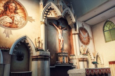 @@Community Landmark:: The Mawsynram Catholic Church stands as a spiritual and social pillar for the substantial Christian population in the village, which is part of the larger Catholic Diocese of the East Khasi Hills. Given its location in the area of the world’s highest rainfall, the church's architecture and material choices are specifically adapted to withstand the extreme monsoonal climate. The structure is typically simple yet sturdy, reflecting the humble, resilient nature of the local Khasi community. It is not generally a grand, historical cathedral but a vital, modern-era community center. The church often serves as a focal point for village gatherings, community service, and cultural preservation, besides being a place of worship. The interior is generally well-maintained, bright, and offers a quiet, serene escape from the constant sounds of the rain outside. The continuous dampness of the climate presents a perpetual challenge to its upkeep, a testament to the local community’s dedication. The church is typically constructed using durable local stone and cement, often featuring a simple, pitched roof to manage water runoff. Its presence provides a powerful cultural juxtaposition against the backdrop of the dense, natural rainforest and traditional Khasi customs. The faithful gather here throughout the year, with special celebrations during Christmas and Easter. It acts as an important symbol of faith and hope in a place where life is physically governed by the constant intensity of the weather. The site often includes a small bell tower or grotto and is typically surrounded by a well-kept garden, adding to its peaceful atmosphere.Show All
Seven Sisters Falls, also known locally as Nohsngithiang Falls, is a breathtaking seven-segmented waterfall situated in the East Khasi Hills district. It is one of the tallest and most iconic waterfalls in India, plunging from a height of 315 Meters (approx. 1,033 Feet). The name 'Seven Sisters' symbolizes the seven sister states of Northeast India: Assam, Arunachal Pradesh, Manipur, Nagaland, Mizoram, Tripura, and Meghalaya. This waterfall is unique because it is a seasonal phenomenon that comes to life with incredible force during the Monsoon season. Unlike other falls that have a single stream, this one features seven distinct segments that flow side-by-side over the limestone cliffs. The sheer scale of the fall, combined with the backdrop of lush green valleys and the vast plains of Bangladesh visible in the distance, makes it a must-visit. During the rainy season, the roar of the water can be heard from a great distance, and the mist created by the crashing water often blankets the entire viewing area. It is a spectacle of nature's power and symmetry, drawing thousands of tourists who wish to witness the raw beauty of the wettest place on earth.
@@Community Landmark:: The Mawsynram Catholic Church stands as a spiritual and social pillar for the substantial Christian population in the village, which is part of the larger Catholic Diocese of the East Khasi Hills. Given its location in the area of the world’s highest rainfall, the church's architecture and material choices are specifically adapted to withstand the extreme monsoonal climate. The structure is typically simple yet sturdy, reflecting the humble, resilient nature of the local Khasi community. It is not generally a grand, historical cathedral but a vital, modern-era community center. The church often serves as a focal point for village gatherings, community service, and cultural preservation, besides being a place of worship. The interior is generally well-maintained, bright, and offers a quiet, serene escape from the constant sounds of the rain outside. The continuous dampness of the climate presents a perpetual challenge to its upkeep, a testament to the local community’s dedication. The church is typically constructed using durable local stone and cement, often featuring a simple, pitched roof to manage water runoff. Its presence provides a powerful cultural juxtaposition against the backdrop of the dense, natural rainforest and traditional Khasi customs. The faithful gather here throughout the year, with special celebrations during Christmas and Easter. It acts as an important symbol of faith and hope in a place where life is physically governed by the constant intensity of the weather. The site often includes a small bell tower or grotto and is typically surrounded by a well-kept garden, adding to its peaceful atmosphere.Show All
Seven Sisters Falls, also known locally as Nohsngithiang Falls, is a breathtaking seven-segmented waterfall situated in the East Khasi Hills district. It is one of the tallest and most iconic waterfalls in India, plunging from a height of 315 Meters (approx. 1,033 Feet). The name 'Seven Sisters' symbolizes the seven sister states of Northeast India: Assam, Arunachal Pradesh, Manipur, Nagaland, Mizoram, Tripura, and Meghalaya. This waterfall is unique because it is a seasonal phenomenon that comes to life with incredible force during the Monsoon season. Unlike other falls that have a single stream, this one features seven distinct segments that flow side-by-side over the limestone cliffs. The sheer scale of the fall, combined with the backdrop of lush green valleys and the vast plains of Bangladesh visible in the distance, makes it a must-visit. During the rainy season, the roar of the water can be heard from a great distance, and the mist created by the crashing water often blankets the entire viewing area. It is a spectacle of nature's power and symmetry, drawing thousands of tourists who wish to witness the raw beauty of the wettest place on earth.Information
-
Why Famous:
World Record Rainfall: Famous globally as the wettest place on Earth. It attracts meteorologists, researchers, and adventure tourists from all over the world.
Mawjymbuin Cave: Known for its sacred stalagmite that draws both pilgrims and geo...World Record Rainfall: Famous globally as the wettest place on Earth. It attracts meteorologists, researchers, and adventure tourists from all over the world.
Mawjymbuin Cave: Known for its sacred stalagmite that draws both pilgrims and geology enthusiasts. It is a prime example of the limestone topography of Meghalaya. -
Architecture:
Cave Formations: The Mawjymbuin Cave is a natural architectural wonder made of limestone. Over thousands of years, water has carved intricate paths and pillars within the cave.
Dimension Details: The cave entrance is about 50 feet wide and ...Cave Formations: The Mawjymbuin Cave is a natural architectural wonder made of limestone. Over thousands of years, water has carved intricate paths and pillars within the cave.
Dimension Details: The cave entrance is about 50 feet wide and 15 feet high. The central stalagmite 'Shiva Linga' stands approximately 4 feet tall and is continuously bathed by water.
Rain-Proof Housing: Traditional houses use sloping roofs with a steep pitch of about 45 degrees to ensure rapid water runoff. This prevents leakages during the massive monsoons. -
How To Reach:
By Air: Umroi Airport in Shillong is about 85 KM away. Guwahati Airport is the most reliable option at 170 KM, with plenty of taxi services.
By Train: Guwahati Railway Station is the nearest railhead. The journey from the station to Mawsyn... -
Near Tourist Places:
Mawjymbuin Cave (1 KM), Mawlyngbna (15 KM), Jakrem (45 KM), Cherrapunji (80 KM by road), Shillong (65 KM), Mawphlang (40 KM), Puriang (20 KM), Krem Puri (30 KM), Um-Khakoi Lake (16 KM), Split Rock (15 KM).
Tourism Tips
-
Health and Safety: Roads can be very slippery and prone to landslides during peak monsoon. Always check the weather forecast and travel with a local driver who knows the terrain.
Packing Essentials: High-quality waterproof gear is a must. ...
Reviews
Mawsynram Itineray And Cost:-
Information about New and Updated Locations() of Meghalaya Has Been Added :-
Card subtitle
Note:-
Information provided here in good Faith and for reference only.
All information and pictures will be updated soon, please keep visiting.
Near Places

Amlarem
Some quick example text to build on the card title and make up the bulk of the card's content.
Go somewhere
Baghmara
Some quick example text to build on the card title and make up the bulk of the card's content.
Go somewhere
Cherrapunji
Some quick example text to build on the card title and make up the bulk of the card's content.
Go somewhere
Dawki
Some quick example text to build on the card title and make up the bulk of the card's content.
Go somewhere
Jowai
Some quick example text to build on the card title and make up the bulk of the card's content.
Go somewhere
Mairang
Some quick example text to build on the card title and make up the bulk of the card's content.
Go somewhere
Mawlynnong
Some quick example text to build on the card title and make up the bulk of the card's content.
Go somewhere
Mawryngkneng
Some quick example text to build on the card title and make up the bulk of the card's content.
Go somewhere
Mawsynram
Some quick example text to build on the card title and make up the bulk of the card's content.
Go somewhere
Nongpoh
Some quick example text to build on the card title and make up the bulk of the card's content.
Go somewherein Other Cities