

Amlarem
General information
-
Ideal Duration:
1 to 2 DaysPlace Type:
Hill Station / NatureEntry Fees:
Entry Fees Heading General Entry: There is no fee to enter the town of Amlarem itself. However, specific sites like Krang Suri Falls may charge a nominal fee of 50 INR per person. This fee helps the local community maintain the cleanliness of the site.
Read MoreEntry Fees Heading General Entry: There is no fee to enter the town of Amlarem itself. However, specific sites like Krang Suri Falls may charge a nominal fee of 50 INR per person. This fee helps the local community maintain the cleanliness of the site.
Entry Fees Heading Activities and Gear: Life jacket rentals at the waterfalls usually cost around 100 INR per person. Parking fees for private vehicles at tourist spots range from 20 to 50 INR. These small charges are vital for the upkeep of the local infrastructure.Timing:
Timings Heading Regular Timings: Most tourist spots like waterfalls and parks are open from 8:00 AM to 5:00 PM. It is advisable to finish your outdoor activities before sunset as mountain roads can be tricky. Markets usually open early in the morning around 7:00 AM.Timings Heading Regular Timings: Most tourist spots like waterfalls and parks are open from 8:00 AM to 5:00 PM. It is advisable to finish your outdoor activities before sunset as mountain roads can be tricky. Markets usually open early in the morning around 7:00 AM.
Timings Heading Ideal Visit Time: The best time to visit is during the morning hours from 9:00 AM to 11:00 AM when the sun illuminates the water clearly. This is especially true for seeing the blue hues of the waterfalls. Weekdays are less crowded than weekends.Special Events:
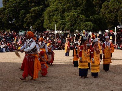
Special Event Heading Behdeinkhlam Festival: This is the most important cultural festival of the Jaintias, celebrated to drive away the demon of plague. It involves vibrant processions, traditional dances, and the immersion of decorative towers. It is a colorful spectacle ...Special Event Heading Behdeinkhlam Festival: This is the most important cultural festival of the Jaintias, celebrated to drive away the demon of plague. It involves vibrant processions, traditional dances, and the immersion of decorative towers. It is a colorful spectacle that showcases the deep-rooted faith of the locals.
Special Event Heading Winter Boat Race: Held in the nearby rivers during the cooler months, these races are a community highlight. Local teams compete in traditional wooden boats, accompanied by cheering crowds and festive food stalls. It is a great time to witness the competitive spirit of the hills.Best Photo Spots:
Photo Spots Heading Krang Suri Viewpoint: The official viewpoint offers a panoramic shot of the entire waterfall and its blue pool. The contrast between the green jungle and the turquoise water is stunning. Best photographed during the early morning light.Photo Spots Heading Krang Suri Viewpoint: The official viewpoint offers a panoramic shot of the entire waterfall and its blue pool. The contrast between the green jungle and the turquoise water is stunning. Best photographed during the early morning light.
Photo Spots Heading Thlumuvi Megalithic Bridge: This ancient stone bridge provides a rustic and historical backdrop for portraits. The surrounding stream and moss-covered rocks add a mystical feel to the images. It is a favorite spot for those seeking "offbeat" travel photos.
Photo Spots Heading Jarain Pitcher Plant Garden: Close-up shots of the carnivorous plants are a hit for macro-photography enthusiasts. The unique shapes and colors of the pitchers make for exotic and interesting subjects. The reflections on the lake also provide great landscape opportunities.Photo Gallery
Things To Do
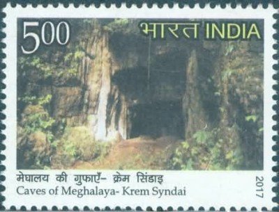 Syndai Caves are a complex network of limestone caverns that hold immense geological and historical significance in the Jaintia Hills. These caves are famous for their intricate formations of stalactites and stalagmites, which have been created over thousands of years by the slow dripping of mineral-rich water. Unlike the more commercialized caves in Meghalaya, Syndai offers a more rugged and authentic exploration experience. Historically, these caves served as vital hideouts and shelters for Jaintia warriors during times of local conflict and colonial resistance. The entrance to the main cave is framed by ancient stone carvings, suggesting it was once a site of religious or ceremonial importance. Inside, the chambers range from narrow, winding passages to vast halls where the ceiling is barely visible in the dark. The air inside is cool and damp, carrying the earthy scent of limestone and history. Exploring these caves requires a flashlight and a sense of adventure, as you navigate through the heart of the mountain. The surrounding Syndai village is equally charming, with traditional houses and friendly locals who are often willing to share legends associated with the underground world. It is a place where nature's slow artistry meets the echoes of a bygone era.
 Rongcheng is a hidden plateau and canyon area known for its breathtaking vistas and rugged beauty. It offers a unique landscape characterized by vast grasslands that suddenly drop into deep, forested canyons. The area is historically significant as it sits along the ancient trade routes that connected the Jaintia Hills with the plains of present-day Bangladesh. Walking across the Rongcheng plateau, visitors can see various megalithic structures and stone markers that tell stories of a bygone era. The silence of the plateau is only broken by the whistling wind, making it a favorite for those seeking solitude. The panoramic views from the edges of the canyon are comparable to the famous Laitlum Canyons, but with much fewer crowds. It is a place of raw, unadulterated nature where the horizon seems to stretch infinitely. The local Khasi and Jaintia people have lived in harmony with this landscape for centuries, and their small hamlets can be seen dotted in the distance. Exploring Rongcheng requires a bit of walking, but every step is rewarded with a new perspective of the Meghalayan highlands. The area is particularly beautiful during the late afternoon when the sun casts long shadows across the golden grass.
 Nongkhnum Island is the largest river island in Meghalaya and the second largest in Asia, formed by the bifurcation of the Kynshi River. Although it is a significant drive from Amlarem, it is often included in broader Jaintia-Khasi circuit tours. The island is a vast expanse of green meadows, sandy beaches, and rocky outcrops. It feels like a different world altogether, far removed from any urban noise. The entry to the island is via a long suspension bridge that offers stunning views of the river splitting into two branches. The island is home to the majestic Weinia Falls and Thum Falls, which are located on its edges. The sandy beach area is perfect for camping and relaxing by the river. The vast grasslands are ideal for long walks and observing the local flora. Because of its remote location, the island remains a pristine paradise for those who enjoy offbeat travel. The local community manages the tourism activities, ensuring that the environment is protected. It is a place where you can spend an entire day just wandering through the meadows or sitting by the roaring waterfalls. The scale of the island and the power of the Kynshi River make it a must-visit for nature enthusiasts.
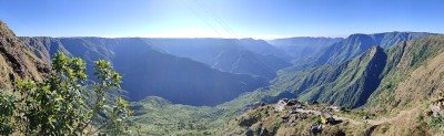 @@Introduction: Laitlum Canyon is often referred to as the "Grand Canyon of the East" due to its vast, sweeping gorges and deep valleys that seem to drop off the edge of the world. The name "Laitlum" literally translates to "End of the Hills" in the local Khasi language, a fitting description for a place where the land suddenly gives way to a breathtaking abyss. Located atop the East Khasi Hills, the viewpoint offers a 360-degree panoramic view of the surrounding mountains, winding roads, and the tiny Rasong Village nestled deep within the valley below. The area is characterized by rolling green meadows that turn a golden hue during the winter months and vibrant emerald during the monsoon. It is a favorite spot for trekkers, who often take the challenge of descending the 3,000 stone steps that lead to the valley floor. Unlike other commercial spots in Meghalaya, Laitlum remains relatively quiet, providing a sense of solitude and peace. The weather here changes rapidly; one moment you might be standing in bright sunlight, and the next, a thick shroud of clouds might roll in, making you feel as if you are walking in the sky. It is a must-visit for anyone seeking raw, cinematic natural beauty.
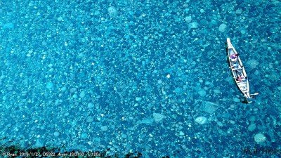
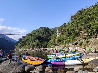 @@Natural Phenomenon: Umngot Boating near Amlarem is an experience that defies belief, as the river's water is so incredibly transparent that boats appear to be floating in mid-air. This phenomenon is most prominent in the village of Shnongpdeng, where the riverbed, composed of colorful pebbles and smooth rocks, is clearly visible even at depths of 15 to 20 feet. The river flows through a narrow gorge, flanked by high cliffs draped in emerald green forests, creating a sanctuary of peace and natural beauty. The serenity of the water is only broken by the gentle ripple of the oars as local boatmen navigate the narrow channels. @@The Experience: A boat ride on the Umngot is a sensory journey. The cool breeze, the sound of distant waterfalls, and the visual clarity of the underwater world create a meditative atmosphere. The local boats are traditional wooden dugouts, expertly crafted to be stable yet agile. As you glide along, you can see schools of fish swimming beneath you, and the play of sunlight on the riverbed creates a shimmering effect that is truly magical. The experience is often described as spiritual, connecting the traveler with the pure, untouched elements of the earth. @@Local Stewardship: The extreme clarity of the river is a testament to the dedicated conservation efforts of the local Khasi and Jaintia communities. They have strictly prohibited littering and use eco-friendly practices to ensure the river remains pristine. Boating here is not just a tourist activity but a sustainable livelihood for the villagers, who take great pride in sharing their natural heritage with visitors. @@Adventure Hub: Beyond the calm boating, the area serves as a hub for water-based adventures. The river's varying depths and currents allow for activities like kayaking and snorkeling. The towering cliffs offer opportunities for cliff jumping into the deep, clear pools. Whether you are looking for a quiet retreat or an adrenaline-filled day, Umngot Boating provides the perfect setting. It is a place that reminds us of the importance of preserving our natural resources and the sheer wonder that can be found in the simplest elements of nature.
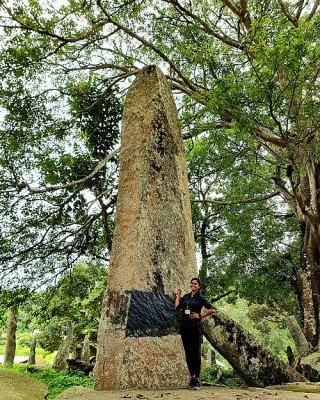 @@Introduction: The Nartiang Monoliths represent one of the most important historical and archaeological sites in Northeast India. Located in the ancient summer capital of the Jaintia Kings, this site features the largest collection of megalithic stones in a single area. These monoliths are divided into two types: Moo Shynrang (Menhirs or upright stones) representing men, and Moo Kynthai (Dolmens or flat stones) representing women. The stones were erected between the 16th and 19th centuries to commemorate the victories of the Jaintia Kings and to honor their ancestors. The site is a sprawling open-ground garden where hundreds of these grey stones stand in silent testimony to a bygone era of tribal royalty. The tallest monolith in the world is found here, standing at an incredible height of 8 meters, believed to have been erected by a legendary lieutenant of the king. Walking through this "Stonehenge of the East," visitors feel a deep sense of history and mystery. The nearby Nartiang Durga Temple, a 500-year-old structure, adds to the cultural significance of the village. The village of Nartiang itself is steeped in legends of giants and warriors, making it a fascinating destination for history buffs and culture seekers. It is a place where the ancient megalithic culture of the Khasi-Jaintia people is preserved in its most grand form.
 The Thlumuwi Stone Bridge is a remarkable historical monument that showcases the engineering brilliance of the Jaintia people. Built over the Muwi stream, this bridge was constructed by the legendary warriors U Mar Phalyngki and U Luh Lamare under the orders of the Jaintia King. Its primary purpose was to facilitate the King’s seasonal travel between his summer capital in Nartiang and his winter capital in Jaintiapur (now in Bangladesh). The bridge is made entirely of massive, well-hewn granite slabs that are perched on heavy stone pillars, standing as a testament to the megalithic culture of the region. Despite being centuries old, the bridge remains a sturdy link to the past, although a portion of it was famously broken when an elephant attempted to cross it. Adjacent to the bridge is the scenic Thlumuwi Falls, which cascades into a clear pool, providing a beautiful backdrop to the stone structure. The area is surrounded by lush green valleys and paddy fields, offering a panoramic view that is both peaceful and historically evocative. Walking across the nearby modern bridges allows visitors to see the ancient stone structure from a perfect angle, appreciating the sheer scale of the rocks used. It is a site where history, legend, and natural beauty converge, making it a must-visit for anyone interested in the heritage of Northeast India.Show All
 Shnongpdeng Village is a picturesque hamlet situated on the banks of the Umngot River, famous for having water so clear that boats appear to be floating in mid-air. Unlike the busier Dawki, Shnongpdeng offers a more relaxed and immersive experience into the riverside lifestyle. The village is a hub for adventure sports, attracting thrill-seekers from all over the world. The river serves as the lifeline of the village, with locals using it for fishing and transport. The suspension bridge hanging over the river provides a bird's eye view of the emerald waters and the rocky riverbed below. During the winter months, the water becomes exceptionally transparent, revealing every pebble and fish. The village itself is clean and well-maintained, reflecting the local community's commitment to eco-tourism. Staying in a riverside tent or a local homestay allows visitors to hear the soothing sound of the river throughout the night. It is a place where adventure meets tranquility, offering activities like kayaking and scuba diving alongside quiet spots for reflection. The hospitality of the Khasi people here is legendary, with many families opening their homes to travelers.
Information
-
Why Famous:
Famous Heading Krang Suri Falls: Amlarem is the primary access point for the stunning Krang Suri waterfall, known for its turquoise blue waters and curtain-like flow. The falls are considered one of the most beautiful in India due to their ethereal color. Tourists flock he...Famous Heading Krang Suri Falls: Amlarem is the primary access point for the stunning Krang Suri waterfall, known for its turquoise blue waters and curtain-like flow. The falls are considered one of the most beautiful in India due to their ethereal color. Tourists flock here to swim in the natural pools and enjoy the limestone formations.
Famous Heading Historical Significance: The area is famous for being a part of the ancient Jaintia Kingdom, with numerous ruins and artifacts scattered nearby. It marks the historical trade route between the hills of Meghalaya and the plains of Bangladesh. This historical bridge between cultures makes it a significant site for heritage enthusiasts. -
Architecture:
Architecture Heading Traditional Jaintia Style: The traditional houses in Amlarem are built using locally sourced bamboo, wood, and thatch, designed to withstand the heavy monsoon rains. Dimensions often follow a rectangular plan of approximately 20x15 feet. These structur...Architecture Heading Traditional Jaintia Style: The traditional houses in Amlarem are built using locally sourced bamboo, wood, and thatch, designed to withstand the heavy monsoon rains. Dimensions often follow a rectangular plan of approximately 20x15 feet. These structures are elevated on stilts to prevent dampness and provide storage underneath. The roofs are steeply pitched to ensure rapid water runoff during the legendary Meghalayan downpours.
Architecture Heading Stone Megaliths: The region is famous for its ancient stone structures, some measuring over 10 feet in height. These megaliths serve as commemorative monuments for tribal ancestors and historical events. The precision with which these massive stones were placed without modern machinery is a testament to ancient engineering. They are often arranged in clusters, creating a stone forest appearance in the open fields. -
How To Reach:
How to Reach Heading By Air: The nearest major airport is in Guwahati, Assam, which is about 190 km away. From there, you can hire a private taxi to reach Amlarem. Shillong airport at Umroi is closer (around 90 km) but has limited flight connectivity.
Read MoreHow to Reach Heading By Air: The nearest major airport is in Guwahati, Assam, which is about 190 km away. From there, you can hire a private taxi to reach Amlarem. Shillong airport at Umroi is closer (around 90 km) but has limited flight connectivity.
How to Reach Heading By Train: Guwahati Railway Station is the closest rail link, well-connected to all major Indian cities. Taxis and buses are readily available from the station for the 5-hour journey to Amlarem. There are no railway lines within the hills of Meghalaya.
How to Reach Heading By Road: Amlarem is well-connected by road to Shillong (95 km) and Jowai (30 km). State transport buses and shared sumos run regularly on these routes. The drive offers scenic views of the Jaintia Hills and deep gorges.
How to Reach Heading By Local Transport: Within Amlarem, you can use local taxis or simply walk to explore the town area. For visiting nearby waterfalls like Krang Suri, hiring a private cab for the day is the most convenient option. Shared taxis are also available for budget travelers.Weather and Best Time to Visit:
Best Time Heading Winter Season: From October to February, the weather is pleasant and the water in the rivers is at its clearest. This is the peak tourist season for photography and water activities. Temperatures can drop at night, so warm clothing is essential.
<...Best Time Heading Winter Season: From October to February, the weather is pleasant and the water in the rivers is at its clearest. This is the peak tourist season for photography and water activities. Temperatures can drop at night, so warm clothing is essential.
Best Time Heading Monsoon Season: From June to September, the waterfalls are at their most powerful and the landscape is incredibly green. However, heavy rains can make trekking and road travel difficult. It is the best time for those who love the "rainy" charm of Meghalaya.
Best Time Heading Time of Day: Early mornings are the best for birdwatching and avoiding the crowds. The light is soft and perfect for landscape photography. Evenings are great for exploring the local markets and enjoying a hot cup of tea.Near Tourist Places:
Krang Suri Falls (3 km), Dawki (25 km), Shnongpdeng (26 km), Jowai (30 km), Jarain Lake (15 km), Tyrshi Falls (35 km), Nartiang Monoliths (55 km), Phe Phe Falls (40 km), Mawlynnong (55 km), Shillong (95 km).Tourism Tips
-
Tourism Tips Heading Health and Safety: Always wear a life jacket when swimming in the waterfall pools, even if you are a strong swimmer. The currents can be deceptive after a rain. Carry a basic first aid kit as medical facilities in rural areas are limited.Tourism Tips Heading Health and Safety: Always wear a life jacket when swimming in the waterfall pools, even if you are a strong swimmer. The currents can be deceptive after a rain. Carry a basic first aid kit as medical facilities in rural areas are limited.
Tourism Tips Heading Packing Essentials: Carry a raincoat or umbrella at all times, as weather in Meghalaya is unpredictable. Sturdy walking shoes are a must for the rocky trails. Don't forget to pack extra batteries for your camera as charging points may be scarce.
Tourism Tips Heading Respect Local Customs: Always ask for permission before taking photos of the local people or their homes. Follow the "Leave No Trace" principle—take your trash back with you. Avoid wearing revealing clothes when visiting villages to respect the conservative culture.
Tourism Tips Heading Cash and Connectivity: Carry enough cash as ATMs are rarely found outside the main town area. Mobile network can be spotty in the valleys, so download offline maps. BSNL and Jio usually provide the best coverage in these hilly regions.
Reviews
FAQs
Amlarem Itineray And Cost:-
Other Places In Meghalaya :-
Other States In India :-
Information about New and Updated Locations() of Meghalaya Has Been Added :-
Card subtitle
Note:-
Information provided here in good Faith and for reference only.
Near Places

Amlarem
Some quick example text to build on the card title and make up the bulk of the card's content.
Go somewhere
Baghmara
Some quick example text to build on the card title and make up the bulk of the card's content.
Go somewhere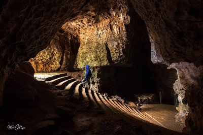
Cherrapunji
Some quick example text to build on the card title and make up the bulk of the card's content.
Go somewhere
Dawki
Some quick example text to build on the card title and make up the bulk of the card's content.
Go somewhere
Jowai
Some quick example text to build on the card title and make up the bulk of the card's content.
Go somewhere
Mairang
Some quick example text to build on the card title and make up the bulk of the card's content.
Go somewhere
Mawlynnong
Some quick example text to build on the card title and make up the bulk of the card's content.
Go somewhere
Mawryngkneng
Some quick example text to build on the card title and make up the bulk of the card's content.
Go somewhere
Mawsynram
Some quick example text to build on the card title and make up the bulk of the card's content.
Go somewhere
Nongpoh
Some quick example text to build on the card title and make up the bulk of the card's content.
Go somewhere
Pynursla
Some quick example text to build on the card title and make up the bulk of the card's content.
Go somewhere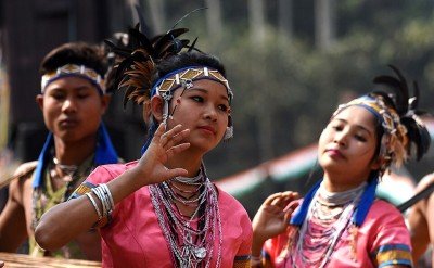
Rongram
Some quick example text to build on the card title and make up the bulk of the card's content.
Go somewhere
Shillong
Some quick example text to build on the card title and make up the bulk of the card's content.
Go somewhere
Tura
Some quick example text to build on the card title and make up the bulk of the card's content.
Go somewhere
Umsning
Some quick example text to build on the card title and make up the bulk of the card's content.
Go somewherein Other Cities