

7th Mile Viewpoint
General information
-
Ideal Duration:
30 Minutes (Sufficient for photography, a quick snack, and enjoying the view).Place Type:
Roadside Viewpoint, Geographical Landmark, and SceEntry Fees:
Viewpoint Access (Free of Charge): There is absolutely no official entry fee to visit and enjoy the views from the 7th Mile Viewpoint. Unrestricted Public Access and State Highway Right-of-Way: As a natural, publicly accessible pullover point located directly on a state hi...Viewpoint Access (Free of Charge): There is absolutely no official entry fee to visit and enjoy the views from the 7th Mile Viewpoint. Unrestricted Public Access and State Highway Right-of-Way: As a natural, publicly accessible pullover point located directly on a state highway, access to the viewing area and the immediate roadside is provided free of cost, ensuring that the natural beauty remains accessible to all travelers. Roadside Parking and Informal Convenience Fee (Small Voluntary Charge): While parking is generally free, during peak season or when local vendors are present, a very small, informal fee (often around Rs.10 - Rs.20) might be requested by local associations for supervising the roadside parking area. Local Area Management and Traffic Control Contribution: This fee is voluntary but customary, helping with the local upkeep and basic traffic management in the limited roadside stopping space.Timing:
Regular Timings (Optimal Daylight Hours for Safety): The viewpoint is best visited between 6:00 AM and 5:30 PM.
Visibility and Night Driving Hazard Avoidance: Although it is a 24-hour location, stopping here after dark is strongly discouraged due to the high risks ...Regular Timings (Optimal Daylight Hours for Safety): The viewpoint is best visited between 6:00 AM and 5:30 PM.
Visibility and Night Driving Hazard Avoidance: Although it is a 24-hour location, stopping here after dark is strongly discouraged due to the high risks associated with mountain driving, poor visibility, and the narrow shoulder area. Daylight hours are mandatory for safety and viewing pleasure. Ideal Visit Time (Pre-Sunrise or Mid-Morning Break): The best time for photography and clarity is approximately 6:30 AM to 8:00 AM.
Atmospheric Clarity and Lack of Road Congestion: At this time, the light is soft, the air is crisp, and the traffic is minimal, allowing for a peaceful and sharp view. It also serves as a perfect mid-morning break (10:30 AM) if you are driving down from Kalimpong town.Special Events:
Local Seasonal Orange Fair (Late November - Early December): In late November or early December, due to its location on a prime route, the nearby roadside often features small, informal seasonal markets.
Harvest Trade and Agricultural Display: Farmers from lower el...Local Seasonal Orange Fair (Late November - Early December): In late November or early December, due to its location on a prime route, the nearby roadside often features small, informal seasonal markets.
Harvest Trade and Agricultural Display: Farmers from lower elevations temporarily set up stalls selling fresh, organic oranges harvested from the surrounding gardens, transforming the viewpoint area into a vibrant, temporary agricultural trade post for the duration of the harvest season.
Road Safety and Awareness Campaigns (Occasional):
Government Public Service and Community Outreach: The location's high traffic volume makes it an occasional site for government or NGO-led campaigns promoting road safety in the hills. These events, usually featuring signage, short demonstrations, or vehicle checks, highlight the critical importance of careful driving on mountain roads to the passing public.Best Photo Spots:
Foreground Railing as a Leading Line:
Perspective and Depth Creation: Place the horizontal line of the protective railing right across the bottom third of your frame. Use this line to lead the viewer's eye steeply down into the valley towar...Foreground Railing as a Leading Line:
Perspective and Depth Creation: Place the horizontal line of the protective railing right across the bottom third of your frame. Use this line to lead the viewer's eye steeply down into the valley toward the river, maximizing the perception of height and the dramatic descent into the gorge.
The View Down the Winding Hill Road:
Curving Road Composition and Travel Narrative: Turn your camera to capture the winding road itself, showing the series of steep hairpins leading away from the viewpoint. This shot emphasizes the difficulty and beauty of the journey, creating a dynamic visual narrative about travel in the Himalayas.
Portrait against the Vast Open Sky:
Personal Scale and Dramatic Backdrop: Take a portrait of a person standing safely near the railing, positioning them slightly off-center. Use the wide, expansive view of the valley and the open sky as a dramatic, beautiful backdrop, contrasting the smallness of the human figure against the large scale of nature.Photo Gallery
Things To Do
-
Capture the Deep Valley Panorama:
Wide-Angle Landscape Photography and Depth Focus: Utilize a wide-angle lens to capture the vast, deep valley, focusing on the winding river below and the layers of distant hills. Compose the shot to emphasize the vertical scale, using the foreground railing or a nearby tree trunk as a reference point to highlight the immense drop.
Observe Traffic and Road Dynamics:
Roadside Observation and Travel Appreciation: Spend time watching the traffic on the distant, lower roads. Seeing vehicles moving slowly along the winding road far below gives a clear appreciation of the distances covered and the engineering feats required to carve out the mountain highways in the challenging Himalayan terrain.
Stretch a...
Hotels
● Fortune Resort Kalimpong
Address: Kalimpong, West Bengal
Distance: 1.5 km
Details: Upscale resort with elegant interiors and modern comforts. Facilities include a restaurant, garden, and spacious rooms. A great choice for those wanti...
● Hotel Mountain View
Address: Kalimpong, West Bengal
Distance: 0.5 km
Details: A central budget hotel offering proximity to the main market and transport. Basic amenities and helpful staff make it a convenient stopover for travel...
● MAYFAIR Himalayan Spa Resort
Address: Kalimpong Khasmahal, Kalimpong, West Bengal
Distance: 1.2 km
Details: Luxury resort offering stunning Kanchenjunga views. Facilities include a world-class spa, fitness center, restaurant, and lush gardens. Perfect for tr...
● Mountain Retreat Ecostay
Address: Chhibo, Kalimpong
Distance: 4.0 km
Details: A charming homestay providing an authentic mountain experience. Facilities include cozy rooms and homestyle food. Perfect for nature lovers wanting a ...
● Pokhrel Lodge
Address: Chotta Bhalukhop, Kalimpong
Distance: 3.5 km
Details: A simple budget lodge located near town. Features clean rooms, early check-in, and local restaurant access. Best for backpackers or those on a tight b...
● Sinclairs Retreat Kalimpong
Address: Kalimpong, West Bengal
Distance: 2.5 km
Details: Well-known retreat offering scenic views and a swimming pool. Facilities include a library, restaurant, and bar. Great for mid-range travelers wanting...
● Sterling Park Kalimpong
Address: Kalimpong, West Bengal
Distance: 2.2 km
Details: A comfortable mid-range property with landscaped lawns and mountain vistas. Offers multi-cuisine dining and polite service. Ideal for a balanced stay ...
● Summit Barsana Resort & Spa
Address: Kalimpong Khasmahal, Kalimpong
Distance: 2.0 km
Details: A modern 3-star resort providing a relaxing spa experience. Facilities include indoor dining, bonfire spots, and comfortable rooms with valley views. ...
● Summit Sherpa Mountain Hotel
Address: Deolo, Kalimpong
Distance: 3.0 km
Details: A budget-friendly hotel with clean rooms and basic amenities. Provides good mountain views and a quiet atmosphere. A reliable choice for budget travel...
● The Elgin Silver Oaks
Address: Kalimpong, West Bengal
Distance: 1.8 km
Details: Heritage resort since 1932. Features a unique colonial charm, landscaped gardens, and premium multi-cuisine dining. Ideal for heritage lovers wanting ...
Show AllInformation
-
Why Famous:
Historical Naming Convention:
Colonial Road Marker and Unique Identity: The viewpoint's fame stems largely from its distinctive, numerically precise name, "7th Mile," which clearly links it to the historical British-era road system that mapp...Historical Naming Convention:
Colonial Road Marker and Unique Identity: The viewpoint's fame stems largely from its distinctive, numerically precise name, "7th Mile," which clearly links it to the historical British-era road system that mapped the Himalayan routes. This simple, literal name gives it an immediate, recognizable identity that tourists and local drivers use as a standard reference point on the road map.
The Dramatic Valley Plunge Perspective:
Depth Perception and Geological Immensity: It is renowned for providing a breathtaking perspective that exaggerates the scale of the descent into the Teesta gorge. The view here often highlights the steep gradient of the surrounding hillsides and the dramatic contrast between the high viewing altitude and the river's low elevation, offering a powerful sense of the region's intense, rugged topography. -
Architecture:
Essential Roadside Viewing Platform: The architecture of the 7th Mile Viewpoint is fundamentally utilitarian, designed to accommodate travelers briefly and safely on a narrow hill road.
Functional Concrete Structure and Road Alignment: The ...Essential Roadside Viewing Platform: The architecture of the 7th Mile Viewpoint is fundamentally utilitarian, designed to accommodate travelers briefly and safely on a narrow hill road.
Functional Concrete Structure and Road Alignment: The viewpoint consists primarily of a reinforced concrete apron or viewing deck, often extending slightly over the hillside to maximize the viewing angle. This platform typically measures around 10 meters by 4 meters, providing a safe space away from traffic.
Protective Railing and Safety Features: Safety is the paramount architectural concern here. High-Tensile Guardrail System and Visitor Protection: A robust steel railing, usually painted brightly for visibility, is installed along the drop-off point. This railing is generally about 1. 3 meters high and extends for the length of the platform, sometimes featuring a low, secondary concrete wall at its base to prevent slips and ensure visitor safety against the steep, dramatic drop into the Teesta gorge below. -
How To Reach:
By Air: The closest airport is Bagdogra Airport (IXB). Air Gateway and Convenient Stopover on Ascent/Descent: The distance is approximately 82 KMS. From IXB, hire a reserved taxi to Kalimpong. This viewpoint is conveniently located on the main road and can be easily incl... -
Near Tourist Places:
Teesta Bazar: 4 KMS (Riverside market and confluence area)
Teesta River View Point: 1 KM (Slightly different river view, often combined)
Kalimpong Market: 11 KMS (Central hub)
Mangal Dham Temple: 10 KMS (Hindu temple)
Durpin Dara Hill: 15 KMS (Monastery and viewpoint)
Pine View Cactus Nursery: 12 KMS (Floral attraction)
Kalimpong Science Centre: 15 KMS (Educational center)
Deolo Hill: 18 KMS (Highest viewpoint)
Lovers Meet Viewpoint (Rangeet/Teesta): 5 KMS (Confluence view)
Lava: 55 KMS (Forest town)
Tourism Tips
-
Health & Safety (Roadside Traffic and Steep Drop):
Traffic Vigilance and Barrier Respect: Crucially, be highly aware of fast-moving vehicles and buses, as this is a working highway. Never cross or lean over the protective railing; the drop...
Reviews
Kalimpong Itineray And Cost:-
7th Mile Viewpoint Tourism:-
Information about New and Updated Locations() of West Bengal Has Been Added :-
Card subtitle
Note:-
Information provided here in good Faith and for reference only.
All information and pictures will be updated soon, please keep visiting.
Near Places

7th Mile Viewpoint
Some quick example text to build on the card title and make up the bulk of the card's content.
Go somewhere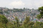
Ahal Dara Viewpoint
Some quick example text to build on the card title and make up the bulk of the card's content.
Go somewhere
Bara Mangwa
Some quick example text to build on the card title and make up the bulk of the card's content.
Go somewhere
Changey Falls
Some quick example text to build on the card title and make up the bulk of the card's content.
Go somewhere
Chatakpur
Some quick example text to build on the card title and make up the bulk of the card's content.
Go somewhere
Chota Mangwa
Some quick example text to build on the card title and make up the bulk of the card's content.
Go somewhere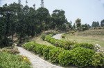
Deolo Hill
Some quick example text to build on the card title and make up the bulk of the card's content.
Go somewhere
Dr. Graham s Homes
Some quick example text to build on the card title and make up the bulk of the card's content.
Go somewhere
Durpin Dara Hill
Some quick example text to build on the card title and make up the bulk of the card's content.
Go somewhere
Durpin Monastery
Some quick example text to build on the card title and make up the bulk of the card's content.
Go somewherein Other Cities