

Place To Visit And Things To Do In Saiha
Things To Do
Chhimtuipui River Bank
@@Natural Grandeur and Ecological Significance:@@The Chhimtuipui River, known in Myanmar as the Kaladan, is the largest river by volume in Mizoram and...
Lakuar Aoh
@@A Panoramic Retreat:@@Lakuar Aoh is a local term, generally referring to a serene, elevated spot or viewpoint that offers stunning panoramic views o...
Mara Autonomous District Council Office Building
@@Administrative and Political Hub:@@The Mara Autonomous District Council (MADC) Office Building is the legislative and administrative center of the M...
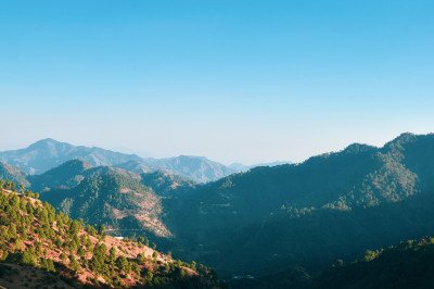
Mara Hills Viewpoint
@@A Region of Lofty Peaks:@@The Mara Hills Viewpoint (distinct from Lakuar Aoh, often higher or on a different ridge) offers one of the most stunning ...
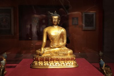
Mara Traditional House Museum
@@Repository of Mara Culture:@@The Mara Traditional House Museum serves as a vital cultural repository, aiming to preserve and showcase the unique her...
Maraland Mission Cemetery
The Maraland Mission Cemetery is a profoundly historical site located in the serene village of Saikao. It serves as the final resting place for the l...
Mount Mawma
Mount Mawma stands majestically as the third-highest mountain in Mizoram, reaching an impressive height of 2,050 meters. It is the highest peak withi...
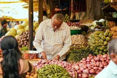
New Saiha Market
@@A Hub of Commerce and Culture:@@The New Saiha Market is the vibrant commercial and social epicenter of Saiha town and the entire Mara region. It is ...
Palak Wildlife Sanctuary
Palak Wildlife Sanctuary is a sprawling protected area of 15.5 square kilometers that encompasses the famous Palak Dil lake. Established in 2004, it ...
Phawngpui National Park
Phawngpui National Park is the most revered peak in Mizoram, standing at 2,157 meters. Known as the Blue Mountain, it is a sanctuary of biodiversity ...
Phura Village Cultural Site
Phura is a significant cultural hub for the Mara people of Mizoram. It serves as the gateway to the largest natural lake in the state, Palak Dil. The...
Saiha Cultural Centre
@@Historical Overview:@@ The Saiha Cultural Centre serves as the primary institution dedicated to preserving and promoting the unique culture and trad...
Saiha Sports Stadium
@@Community Hub:@@ The Saiha Sports Stadium is more than just an athletic field; it is a central community and social landmark in Saiha. Its existence...
Saiha Town Viewpoint
@@Geographical Significance:@@ The Saiha Town Viewpoint is strategically located on an elevated section of the road leading out of Saiha towards the f...
Saikao - Lorrain Ville
Saikao, also known as Serkawr, is a village of immense historical and religious significance in the Saiha district. It is famous for Lorrain Ville, t...
Siaha District Museum
@@Institutional Significance:@@ The Siaha District Museum, located centrally near the Mara Autonomous District Council (MADC) Secretariat, is a key in...
Siaha Public Park
@@Role in Urban Life:@@ The Siaha Public Park (often simply called Saiha Public Park) is a vital green lung and recreational oasis situated right in t...
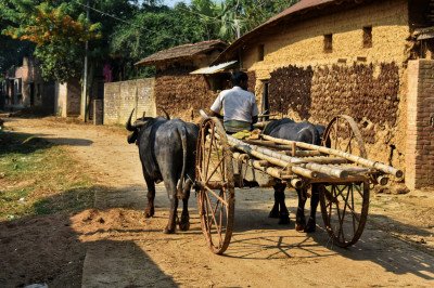
Tuipang Town
Tuipang is the second-largest town in the Saiha district and serves as a major sub-headquarters for the Mara Autonomous District Council. It is a bus...
Vartek Tlang
@@Natural and Historical Landscape:@@ Vartek Tlang is a prominent local peak or Tlang (hill) situated on the outskirts of Saiha town, offering one of ...
Saiha Itineray And Cost:-
Information about New and Updated Locations() of Mizoram Has Been Added :-
Card subtitle
Note:-
Information provided here in good Faith and for reference only.
All information and pictures will be updated soon, please keep visiting.
Near Places

Aizawl
Some quick example text to build on the card title and make up the bulk of the card's content.
Go somewhere
Champhai
Some quick example text to build on the card title and make up the bulk of the card's content.
Go somewhere
Chhingpuii Thlan
Some quick example text to build on the card title and make up the bulk of the card's content.
Go somewhere
Hmuifang
Some quick example text to build on the card title and make up the bulk of the card's content.
Go somewhere
Hnahthial
Some quick example text to build on the card title and make up the bulk of the card's content.
Go somewhere
Khawzawl
Some quick example text to build on the card title and make up the bulk of the card's content.
Go somewhere
Kolasib
Some quick example text to build on the card title and make up the bulk of the card's content.
Go somewhere
Lawngtlai
Some quick example text to build on the card title and make up the bulk of the card's content.
Go somewhere
Lunglei
Some quick example text to build on the card title and make up the bulk of the card's content.
Go somewhere
Mamit
Some quick example text to build on the card title and make up the bulk of the card's content.
Go somewhere