

Chikmagalur
General information
-
Ideal Duration:
3 to 5 DaysPlace Type:
Hill Station & CoffeeEntry Fees:
National Park Fees: Kudremukh entry and trekking permits cost around 200-500 INR. It is strictly regulated, and only a limited number of people are allowed daily.
Jeep Ride Fees: To reach falls like Hebbe or Jhari, private jeeps charge 500-...National Park Fees: Kudremukh entry and trekking permits cost around 200-500 INR. It is strictly regulated, and only a limited number of people are allowed daily.
Jeep Ride Fees: To reach falls like Hebbe or Jhari, private jeeps charge 500-1000 INR. These rides are bumpy but necessary as normal cars cannot reach.Timing:
Plantation Timings: Most estates allow tours from 10:00 AM to 4:00 PM by appointment. It is best to book through your homestay for a more personal experience.
Peak Hours: Visit Mullayanagiri before 9:00 AM to avoid the heavy tourist traffic...Plantation Timings: Most estates allow tours from 10:00 AM to 4:00 PM by appointment. It is best to book through your homestay for a more personal experience.
Peak Hours: Visit Mullayanagiri before 9:00 AM to avoid the heavy tourist traffic. The gates for certain forest roads may close by 6:00 PM for safety.Special Events:
Chikmagalur Festival: A celebration of local culture, arts, and the coffee industry. It features music concerts, food stalls, and traditional sports like Kambala.
Sringeri Sharadamba Rathotsava: The annual car festival which sees thousands ...Chikmagalur Festival: A celebration of local culture, arts, and the coffee industry. It features music concerts, food stalls, and traditional sports like Kambala.
Sringeri Sharadamba Rathotsava: The annual car festival which sees thousands of devotees. The colorful procession and traditional rituals are a treat for cultural enthusiasts.Best Photo Spots:
Mullayanagiri Curves: Capture the winding roads disappearing into the thick mountain mist. The early morning light creates a magical atmosphere for landscape photographers.
Kudremukh View: The "Horse Face" peak offers a unique silhouette ag...Mullayanagiri Curves: Capture the winding roads disappearing into the thick mountain mist. The early morning light creates a magical atmosphere for landscape photographers.
Kudremukh View: The "Horse Face" peak offers a unique silhouette against the sky. The rolling green hills of the national park look like a Windows wallpaper.Photo Gallery
Things To Do
 @@Fort Details: Perched at an altitude of 1,509 meters, the Ballalarayana Durga Fort is a majestic ruin that whispers tales of the Hoysala Empire. Built in the 12th century, it was a strategic military outpost designed to monitor the mountain passes and protect the kingdom from invaders. The trek to the fort is as famous as the structure itself, leading visitors through dense Shola forests and expansive grasslands that turn vibrant green during the rains. From the summit, one can witness a breathtaking 360-degree view of the Western Ghats, with the Netravati river valley visible on clear days. The fort is currently in a state of ruin, but the massive stone walls and bastions that remain give a sense of its former grandeur. It is an "off-the-beaten-path" destination, favored by serious trekkers and history enthusiasts who seek solitude and adventure. Legend has it that the queen of the fort committed suicide at the nearby Rani Jhari peak to avoid capture, adding a layer of tragic mystery to the location. The silence at the top is only broken by the whistling wind and the calls of mountain birds. It is a place that demands physical effort but rewards you with some of the most spectacular vistas in South India.
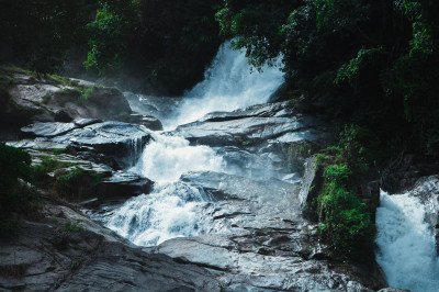 @@Etymology and Natural Description: The name Manikyadhara translates to "String of Pearls," a description perfectly capturing the sight of the water cascading down the steep rock face. The water breaks into countless droplets, which, when illuminated by the sun, shimmer like a curtain of pearls, creating a truly enchanting and unforgettable natural spectacle. The falls are a perennial, though moderate, waterfall, meaning they offer a refreshing view even during the dry summer months, unlike many seasonal falls. They originate high up in the Baba Budan Giri range, which is also known as the Chandra Drona Parvatha. The height of the falls is roughly 30 feet. The surrounding landscape is characterized by the lush, evergreen shola forests typical of the high-altitude Western Ghats. The clean, sparkling water collects into a small pool at the base. @@Religious and Medicinal Significance: Beyond its natural beauty, Manikyadhara Falls holds profound dual religious significance, being a holy site for both the Hindu and Muslim communities, a testament to the syncretic culture of the region. Local legend attributes the origin of the water to the prayers of a Sufi saint, Hazrat Dada Hayat Mir Qalandhar (or Baba Budan in another account), who sought water for his disciples. For Hindus, the water is also referred to as Nellikai Theertham. The water is widely believed to possess miraculous medicinal properties, particularly for curing skin ailments and other diseases, prompting pilgrims to take a holy dip. It is said that leaving a piece of clothing or tying a bangle to the surrounding fences after the bath can lead to wishes being fulfilled. This blend of natural allure, spiritual sanctity, and local folklore makes the falls a must-visit destination, drawing not only nature lovers and trekkers but also devout pilgrims seeking blessings and healing. The tranquil environment provides a perfect retreat from the commotion of city life, offering space for relaxation, picnic, and peaceful contemplation. The area is safeguarded to preserve its religious and ecological purity.
 @@Historical and Religious Synthesis: Baba Budangiri, also called Dattatreya Peetha or Datta Peeta, is a powerful symbol of communal harmony, hosting a shrine that is sacred to both Hindus and Muslims, a phenomenon extremely rare and spiritually significant. The site is named after the Sufi saint, Baba Budan, who is credited with introducing coffee to India around 1670 AD by planting seven coffee beans smuggled from Mocha, Yemen. The hill is part of the Chandra Drona Parvatha range, forming a crescent shape that enhances its mystical allure. The central shrine is a cave, believed to be the residence of the Sufi saint, as well as the Hindu deity, Dattatreya Swamy. This unique blend of two major faiths draws pilgrims and tourists alike throughout the year. The entire peak stands at an altitude of 1895 meters, making it the second highest in Karnataka. The journey to the peak is as rewarding as the destination, passing through thick forests, grasslands, and challenging curves. The surrounding environment is characterized by the unique Shola grassland-forest ecosystem, home to diverse flora and fauna. Three major caves are sanctified by the three Siddhas (Hindu holy figures), adding another layer of religious importance. The view from the top is breathtaking, offering panoramic vistas of the Western Ghats and the entire Chikmagalur valley, especially during sunrise and sunset. This spot is a quintessential experience for anyone visiting Chikmagalur, blending spirituality, history, and raw natural beauty. The region is also famous for the rare Neelakurinji flowers which bloom once every twelve years, covering the hills in a spectacular blue carpet. The main festive occasions are the Urs festival for Muslims and Kartik Poornima for Hindus, both celebrated with great reverence and attracting huge crowds, further highlighting the site's role as a pilgrimage center. The weather is cool and misty most of the year, providing a perfect climate for trekking and contemplation, making it a must-visit destination in the Malnad region of Karnataka, India:
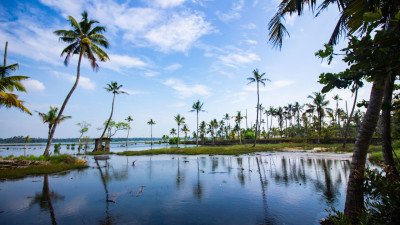 @@Hydrological and Ecosystem Details: Nallur Lake is a medium-sized, man-made reservoir, constructed primarily for agricultural irrigation purposes, catering to the surrounding paddy fields and coffee plantations of the Nallur valley. The lake is fed by local streams and seasonal rain runoff from the nearby foothills. Its water body covers a modest area, but the vast, open surroundings of agricultural land and small hillocks give it a sense of wide-open tranquility. The lake supports a local ecosystem, serving as a habitat for various species of local and migratory water birds, especially during the winter months. The lake's water level fluctuates significantly between the dry season (March to May) and the post-monsoon period (October to December), with the latter offering the fullest and most scenic views. The lake's embankment structure is a classic example of reservoir engineering. @@Local Cultural Importance: Beyond its utility, the lake holds importance as a local recreational spot, a place for village children to play, and a source of fish for the local community. It is a symbol of agricultural prosperity for the Nallur village. The environment is one of peaceful, rural charm, far removed from the tourist crowds of the main hill stations, allowing for a genuine experience of the Malnad countryside. The quietude and simple beauty make it a hidden gem for visitors seeking an authentic, non-commercialized natural escape in the Chikmagalur region. The backdrop of the sun setting over the calm waters is a defining visual feature of this quiet water body.
@@The Serene Water Body of Aldur: Dantaramakki Lake is a relatively unknown but highly tranquil artificial reservoir nestled in the verdant landscape near the village of Aldur in Chikmagalur. Primarily constructed for irrigation purposes, the lake and its surrounding area have evolved into a peaceful spot for locals and a quiet retreat for tourists looking for a non-commercialized natural setting. The lake is expansive, its calm waters reflecting the surrounding low-lying hills and the ubiquitous coffee plantations, creating a picturesque scene that is especially stunning during the early morning and late afternoon hours. Unlike the mountain lakes that cater heavily to trekkers, Dantaramakki Lake provides a gentle, easy-access environment suitable for picnics, leisurely walks along its banks, and quiet contemplation. The atmosphere is one of profound serenity, interrupted only by the sounds of local birds and the gentle lapping of water. The shoreline is often lined with indigenous trees and shrubs, supporting a local ecosystem of small wildlife and migratory birds, making it a modest but rewarding spot for birdwatchers. The path around the lake allows for pleasant, unhurried exploration. The water body itself plays a critical role in sustaining the agriculture of the Dantaramakki village and the larger Aldur region, highlighting its economic importance alongside its natural beauty. The absence of commercial infrastructure, such as dedicated boating facilities or large tourist shops, preserves its rustic, authentic charm. Visitors appreciate the unadulterated view of the Malnad countryside, where the green-covered hills gently slope down to the water's edge. The surrounding terrain is less rugged than the Mullayanagiri or Baba Budangiri ranges, offering a softer, more pastoral aesthetic. It is an ideal destination for families and travelers who prefer a relaxed pace, seeking to capture the quiet, reflective side of Chikmagalur's natural splendour, away from the adrenaline-pumping tourist trails. The best time to visit is during the post-monsoon season when the water level is high and the surrounding greenery is at its most vibrant best, offering the most captivating views and photography opportunities:
@@Spiritual and Topographical Features: Seethalayyanagiri is highly regarded both for its stunning topographical views and its deep spiritual significance. The hill is named after the ancient Seethala Mallikarjuna Swamy Temple located right at the summit. The temple is dedicated to Lord Shiva (Mallikarjuna) and is strongly associated with the epic Ramayana, with a local belief that Lord Rama and Sita visited or resided in the nearby cave. The most unique spiritual aspect is the Shivlinga inside the temple, which is perpetually surrounded by water, giving the temple a mystical, cool, and serene atmosphere year-round. Topographically, the hill provides magnificent, sweeping, panoramic views of the Western Ghats' valleys, especially the vast expanses of the coffee estates and shola forests, often enveloped in a soft, picturesque mist. @@Junction and Trekking Start Point: Geographically, it serves as a critical junction point. It is the end of the easy motorable road and the popular starting point for the trek to Mullayanagiri (the famous 4-km trek). The area is surrounded by rich biodiversity, with the shola forests harboring unique flora and fauna, including some rare wildflowers and orchids, especially during the post-monsoon months. The cool, crisp, misty atmosphere of the hill station provides a tranquil retreat, offering a beautiful blend of spiritual devotion and natural exploration. The vantage point from the summit is considered one of the best in the region.
@@A Sanctuary of Natural and Spiritual Flow: Honnamana Falls, also known by its sacred names Nellikayi Theertha or Manikya Dhara Falls, is a small yet highly revered waterfall located on the route to Baba Budangiri Peak. Its name is derived from the local deity, Goddess Honnammana, whom the villagers worship. The spiritual significance of the falls is dual-layered, as it is considered sacred by both the local Hindu and Muslim communities, often being associated with the mythical water source sought by the Sufi saint Baba Budan and his four followers—the name Manikya Dhara means 'String of Pearls', referencing the gentle cascade. Though the fall's height is modest, around 30 feet, its location is what makes it spectacular: it is completely nestled within a dense cluster of towering trees and thick forest, offering a shady, cool, and perpetually misty micro-environment right beside the road. The waterfall is often visible from the roadside, making it highly accessible. The water flows over naturally tiered rocks, creating a gentle, soothing sound rather than a thundering roar. The surrounding area is characterized by the rich biodiversity of the Shola forests and the meticulously managed coffee plantations, providing a vibrant, lush green backdrop throughout the year. The location's ease of access and its sacred status make it a popular stop for pilgrims and tourists heading to the higher peaks. The environment around Honnamana Falls is exceptionally tranquil and considered a perfect spot for nature lovers who appreciate a quiet moment and a gentle connection with the spiritual landscape of the hills. It also offers beautiful views of the Baba Budangiri hills looming in the distance. Its status as Nellikayi Theertha (Gooseberry Water) in local mythology further enhances its uniqueness. The overall experience is one of peaceful reflection and an appreciation for the blend of spiritual legend and natural beauty, an accessible snapshot of the Malnad region's charm. It is one of the closest major waterfalls to Chikmagalur town and requires only a brief stop to fully appreciate its charm:Show All
@@Topographical and Geographical Details: Standing at an impressive altitude of 1,930 meters (approximately 6,330 feet) above sea level, Mullayanagiri holds the distinction of being the highest peak in the state of Karnataka. It is an integral part of the Baba Budan Giri range and is often cited as the fourth-highest peak between the Nilgiri Hills and the Himalayas. The geographical features include rolling, bald grasslands, dense patches of shola forests in the valleys, and sheer, rocky slopes near the summit. The peak is named after a sage, Mulappa Swamy, who is believed to have meditated in a cave near the summit. The air at the top is intensely crisp and cool, even during the summer months, offering a dramatic climate change from the plains. @@Climate and Bio-diversity: The climate is characterized by heavy mist and strong winds almost year-round. This high-altitude climate supports a unique ecosystem of shola-grassland mosaic, which is home to diverse flora, including rare orchids, and fauna, such as the Nilgiri Wood Pigeon. The panoramic view from the summit encompasses miles of the Western Ghats, often appearing as a turbulent sea of clouds and misty, undulating hills. The spectacular views of sunrise and sunset are a primary attraction, drawing hundreds of visitors daily. The sheer scale and altitude make it a challenging yet rewarding destination for adventure tourists and a beacon for trekkers from all over India. The strategic location also makes it a site for a police radio relay station. The raw, untamed nature of the peak, combined with its accessibility by road up to a point, makes it a perfect blend of adventure and serene natural beauty, solidifying its place as a top tourist magnet in Chikmagalur. The trek from Sarpadaari is considered one of the best trekking trails in South India.
@@Hydrological and Ecosystem Details: Nallur Lake is a medium-sized, man-made reservoir, constructed primarily for agricultural irrigation purposes, catering to the surrounding paddy fields and coffee plantations of the Nallur valley. The lake is fed by local streams and seasonal rain runoff from the nearby foothills. Its water body covers a modest area, but the vast, open surroundings of agricultural land and small hillocks give it a sense of wide-open tranquility. The lake supports a local ecosystem, serving as a habitat for various species of local and migratory water birds, especially during the winter months. The lake's water level fluctuates significantly between the dry season (March to May) and the post-monsoon period (October to December), with the latter offering the fullest and most scenic views. The lake's embankment structure is a classic example of reservoir engineering. @@Local Cultural Importance: Beyond its utility, the lake holds importance as a local recreational spot, a place for village children to play, and a source of fish for the local community. It is a symbol of agricultural prosperity for the Nallur village. The environment is one of peaceful, rural charm, far removed from the tourist crowds of the main hill stations, allowing for a genuine experience of the Malnad countryside. The quietude and simple beauty make it a hidden gem for visitors seeking an authentic, non-commercialized natural escape in the Chikmagalur region. The backdrop of the sun setting over the calm waters is a defining visual feature of this quiet water body.
@@The Serene Water Body of Aldur: Dantaramakki Lake is a relatively unknown but highly tranquil artificial reservoir nestled in the verdant landscape near the village of Aldur in Chikmagalur. Primarily constructed for irrigation purposes, the lake and its surrounding area have evolved into a peaceful spot for locals and a quiet retreat for tourists looking for a non-commercialized natural setting. The lake is expansive, its calm waters reflecting the surrounding low-lying hills and the ubiquitous coffee plantations, creating a picturesque scene that is especially stunning during the early morning and late afternoon hours. Unlike the mountain lakes that cater heavily to trekkers, Dantaramakki Lake provides a gentle, easy-access environment suitable for picnics, leisurely walks along its banks, and quiet contemplation. The atmosphere is one of profound serenity, interrupted only by the sounds of local birds and the gentle lapping of water. The shoreline is often lined with indigenous trees and shrubs, supporting a local ecosystem of small wildlife and migratory birds, making it a modest but rewarding spot for birdwatchers. The path around the lake allows for pleasant, unhurried exploration. The water body itself plays a critical role in sustaining the agriculture of the Dantaramakki village and the larger Aldur region, highlighting its economic importance alongside its natural beauty. The absence of commercial infrastructure, such as dedicated boating facilities or large tourist shops, preserves its rustic, authentic charm. Visitors appreciate the unadulterated view of the Malnad countryside, where the green-covered hills gently slope down to the water's edge. The surrounding terrain is less rugged than the Mullayanagiri or Baba Budangiri ranges, offering a softer, more pastoral aesthetic. It is an ideal destination for families and travelers who prefer a relaxed pace, seeking to capture the quiet, reflective side of Chikmagalur's natural splendour, away from the adrenaline-pumping tourist trails. The best time to visit is during the post-monsoon season when the water level is high and the surrounding greenery is at its most vibrant best, offering the most captivating views and photography opportunities:
@@Spiritual and Topographical Features: Seethalayyanagiri is highly regarded both for its stunning topographical views and its deep spiritual significance. The hill is named after the ancient Seethala Mallikarjuna Swamy Temple located right at the summit. The temple is dedicated to Lord Shiva (Mallikarjuna) and is strongly associated with the epic Ramayana, with a local belief that Lord Rama and Sita visited or resided in the nearby cave. The most unique spiritual aspect is the Shivlinga inside the temple, which is perpetually surrounded by water, giving the temple a mystical, cool, and serene atmosphere year-round. Topographically, the hill provides magnificent, sweeping, panoramic views of the Western Ghats' valleys, especially the vast expanses of the coffee estates and shola forests, often enveloped in a soft, picturesque mist. @@Junction and Trekking Start Point: Geographically, it serves as a critical junction point. It is the end of the easy motorable road and the popular starting point for the trek to Mullayanagiri (the famous 4-km trek). The area is surrounded by rich biodiversity, with the shola forests harboring unique flora and fauna, including some rare wildflowers and orchids, especially during the post-monsoon months. The cool, crisp, misty atmosphere of the hill station provides a tranquil retreat, offering a beautiful blend of spiritual devotion and natural exploration. The vantage point from the summit is considered one of the best in the region.
@@A Sanctuary of Natural and Spiritual Flow: Honnamana Falls, also known by its sacred names Nellikayi Theertha or Manikya Dhara Falls, is a small yet highly revered waterfall located on the route to Baba Budangiri Peak. Its name is derived from the local deity, Goddess Honnammana, whom the villagers worship. The spiritual significance of the falls is dual-layered, as it is considered sacred by both the local Hindu and Muslim communities, often being associated with the mythical water source sought by the Sufi saint Baba Budan and his four followers—the name Manikya Dhara means 'String of Pearls', referencing the gentle cascade. Though the fall's height is modest, around 30 feet, its location is what makes it spectacular: it is completely nestled within a dense cluster of towering trees and thick forest, offering a shady, cool, and perpetually misty micro-environment right beside the road. The waterfall is often visible from the roadside, making it highly accessible. The water flows over naturally tiered rocks, creating a gentle, soothing sound rather than a thundering roar. The surrounding area is characterized by the rich biodiversity of the Shola forests and the meticulously managed coffee plantations, providing a vibrant, lush green backdrop throughout the year. The location's ease of access and its sacred status make it a popular stop for pilgrims and tourists heading to the higher peaks. The environment around Honnamana Falls is exceptionally tranquil and considered a perfect spot for nature lovers who appreciate a quiet moment and a gentle connection with the spiritual landscape of the hills. It also offers beautiful views of the Baba Budangiri hills looming in the distance. Its status as Nellikayi Theertha (Gooseberry Water) in local mythology further enhances its uniqueness. The overall experience is one of peaceful reflection and an appreciation for the blend of spiritual legend and natural beauty, an accessible snapshot of the Malnad region's charm. It is one of the closest major waterfalls to Chikmagalur town and requires only a brief stop to fully appreciate its charm:Show All
@@Topographical and Geographical Details: Standing at an impressive altitude of 1,930 meters (approximately 6,330 feet) above sea level, Mullayanagiri holds the distinction of being the highest peak in the state of Karnataka. It is an integral part of the Baba Budan Giri range and is often cited as the fourth-highest peak between the Nilgiri Hills and the Himalayas. The geographical features include rolling, bald grasslands, dense patches of shola forests in the valleys, and sheer, rocky slopes near the summit. The peak is named after a sage, Mulappa Swamy, who is believed to have meditated in a cave near the summit. The air at the top is intensely crisp and cool, even during the summer months, offering a dramatic climate change from the plains. @@Climate and Bio-diversity: The climate is characterized by heavy mist and strong winds almost year-round. This high-altitude climate supports a unique ecosystem of shola-grassland mosaic, which is home to diverse flora, including rare orchids, and fauna, such as the Nilgiri Wood Pigeon. The panoramic view from the summit encompasses miles of the Western Ghats, often appearing as a turbulent sea of clouds and misty, undulating hills. The spectacular views of sunrise and sunset are a primary attraction, drawing hundreds of visitors daily. The sheer scale and altitude make it a challenging yet rewarding destination for adventure tourists and a beacon for trekkers from all over India. The strategic location also makes it a site for a police radio relay station. The raw, untamed nature of the peak, combined with its accessibility by road up to a point, makes it a perfect blend of adventure and serene natural beauty, solidifying its place as a top tourist magnet in Chikmagalur. The trek from Sarpadaari is considered one of the best trekking trails in South India.Information
-
Why Famous:
Mullayanagiri Peak: Famous for its 1,930-meter height and the small temple at the summit. The drive up the winding roads through the mist is a thrill for every traveler.
Baba Budangiri: A sacred pilgrimage site for both Hindus and Muslims l...Mullayanagiri Peak: Famous for its 1,930-meter height and the small temple at the summit. The drive up the winding roads through the mist is a thrill for every traveler.
Baba Budangiri: A sacred pilgrimage site for both Hindus and Muslims located in the hills. The caves and the Datta Peeta are of great historical and religious importance.
Hebbe Falls: A spectacular two-tiered waterfall hidden deep within a coffee estate. The water is believed to have medicinal properties due to the herbs it flows over. -
Architecture:
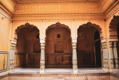
Hoysala and Dravidian: The Vidyashankara Temple in Sringeri is an architectural masterpiece. It features 12 pillars representing the zodiac signs, hit by sunlight in sequence.
Temple Dimensions: The temple is built on a high platform and is...Hoysala and Dravidian: The Vidyashankara Temple in Sringeri is an architectural masterpiece. It features 12 pillars representing the zodiac signs, hit by sunlight in sequence.
Temple Dimensions: The temple is built on a high platform and is made of soapstone. The circular shape and the sculpted walls reflect the peak of Hoysala art.
Colonial Estate Houses: The old planters' bungalows use high ceilings and wrap-around porches. These "Heritage Homes" are designed to stay cool and dry in the heavy monsoon rains. -
How To Reach:
By Air: Mangaluru Airport is the closest at 150 KMS, while Bengaluru is 250 KMS. Both are well-connected by taxis that offer scenic drives through the Ghats.
By Train: Chikmagalur Railway Station is connected via Kadur to the main line. Ma... -
Near Tourist Places:
1. Mullayanagiri (20 KM), 2. Baba Budangiri (25 KM), 3. Hebbe Falls (65 KM), 4. Sringeri (85 KM), 5. Kudremukh (95 KM), 6. Kemmangundi (60 KM), 7. Belur (25 KM), 8. Halebidu (35 KM), 9. Bhadra Wildlife (40 KM), 10. Hirekolale Lake (10 KM).
Tourism Tips
-
Health & Safety: Leeches are common in the forest during monsoon; carry salt or tobacco. Mountain roads have many hairpin bends, so drive slowly and use your horn.
Packing Essentials: Pack a good raincoat, sturdy trekking shoes, and warm w...
Reviews
Chikmagalur Itineray And Cost:-
Information about New and Updated Locations() of Karnataka Has Been Added :-
Card subtitle
Note:-
Information provided here in good Faith and for reference only.
All information and pictures will be updated soon, please keep visiting.
Near Places
Badami
Some quick example text to build on the card title and make up the bulk of the card's content.
Go somewhere
Belagavi
Some quick example text to build on the card title and make up the bulk of the card's content.
Go somewhere
Belur
Some quick example text to build on the card title and make up the bulk of the card's content.
Go somewhere
Bengaluru
Some quick example text to build on the card title and make up the bulk of the card's content.
Go somewhere
Bidar
Some quick example text to build on the card title and make up the bulk of the card's content.
Go somewhere
Bijapur
Some quick example text to build on the card title and make up the bulk of the card's content.
Go somewhere
Chamarajanagar
Some quick example text to build on the card title and make up the bulk of the card's content.
Go somewhere
Chikkaballapur
Some quick example text to build on the card title and make up the bulk of the card's content.
Go somewhere
Chikmagalur
Some quick example text to build on the card title and make up the bulk of the card's content.
Go somewhere
Coorg
Some quick example text to build on the card title and make up the bulk of the card's content.
Go somewherein Other Cities