

Place To Visit And Things To Do In Chikmagalur
Things To Do
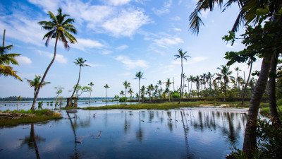
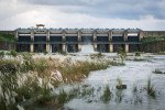
Ayyanakere Lake
@@Lake Details: Ayyanakere Lake is the largest lake in the Chikmagalur district and serves as a vital lifeline for the local agricultural community. I...
Baba Budangiri/Dattatreya Peetha
@@Historical and Religious Synthesis: Baba Budangiri, also called Dattatreya Peetha or Datta Peeta, is a powerful symbol of communal harmony, hosting ...
Ballalarayana Durga Fort
@@Fort Details: Perched at an altitude of 1,509 meters, the Ballalarayana Durga Fort is a majestic ruin that whispers tales of the Hoysala Empire. Bui...
Bhadra Wildlife Sanctuary
@@Sanctuary Details: Bhadra Wildlife Sanctuary, also popularly known as Muthodi Wildlife Sanctuary, is a premier Project Tiger reserve spread across 4...
Coffee Museum Chikmagalur
@@A Journey from Bean to Brew: The Coffee Museum Chikmagalur is an initiative by the Coffee Board of India designed to educate the public on the entir...
Dabdabe Falls
@@The Unspoiled Wilderness Cascade: Dabdabe Falls, sometimes confused with or simply known locally as a major stream in the Ballalarayana Durga region...
Dantaramakki Lake
@@The Serene Water Body of Aldur: Dantaramakki Lake is a relatively unknown but highly tranquil artificial reservoir nestled in the verdant landscape ...
Gadaikallu View Point
@@Historical Fortress in the Sky: Gadaikallu View Point, also known as Jamalabad Fort, is an imposing monolithic rock formation located near Belthanga...
Hebbe Falls
@@Falls Details: Hebbe Falls is a spectacular natural waterfall located inside a private coffee estate within the Bhadra Wildlife Sanctuary. The water...
Hirekolale Lake
@@The Water Mirror of the Hills: Hirekolale Lake is a captivating man-made water body celebrated for its exceptional beauty, especially during sunrise...
Honnamana Falls
@@A Sanctuary of Natural and Spiritual Flow: Honnamana Falls, also known by its sacred names Nellikayi Theertha or Manikya Dhara Falls, is a small yet...
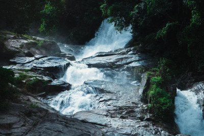
Jhari Waterfalls
@@The Magnificent Buttermilk Cascade: Jhari Waterfalls, affectionately and commonly known as Buttermilk Falls, is a stunning, multi-tiered natural spe...
Manikyadhara Falls
@@Etymology and Natural Description: The name Manikyadhara translates to "String of Pearls," a description perfectly capturing the sight of the water ...
Mullayanagiri Peak
@@Topographical and Geographical Details: Standing at an impressive altitude of 1,930 meters (approximately 6,330 feet) above sea level, Mullayanagiri...
Mullayyana Giri Twin Caves
@@Geological and Historical Details: The Mullayyana Giri Twin Caves are a set of natural rock shelters formed by the intense geological and climatic f...
Nallur Lake
@@Hydrological and Ecosystem Details: Nallur Lake is a medium-sized, man-made reservoir, constructed primarily for agricultural irrigation purposes, c...
Rangana Betta
@@Natural and Cultural Blending: Rangana Betta is a charming destination that perfectly encapsulates the blend of natural beauty and spiritual heritag...
Ratnagiri Bore – Mahatma Gandhi Park
@@Landscape and Recreational Design: This is a beautifully conceived and maintained urban park that blends formal gardening with natural landscape ele...
Seethalayyanagiri
@@Spiritual and Topographical Features: Seethalayyanagiri is highly regarded both for its stunning topographical views and its deep spiritual signific...
Chikmagalur Itineray And Cost:-
Information about New and Updated Locations() of Karnataka Has Been Added :-
Card subtitle
Note:-
Information provided here in good Faith and for reference only.
All information and pictures will be updated soon, please keep visiting.
Near Places
Badami
Some quick example text to build on the card title and make up the bulk of the card's content.
Go somewhere
Belagavi
Some quick example text to build on the card title and make up the bulk of the card's content.
Go somewhere
Belur
Some quick example text to build on the card title and make up the bulk of the card's content.
Go somewhere
Bengaluru
Some quick example text to build on the card title and make up the bulk of the card's content.
Go somewhere
Bidar
Some quick example text to build on the card title and make up the bulk of the card's content.
Go somewhere
Bijapur
Some quick example text to build on the card title and make up the bulk of the card's content.
Go somewhere
Chamarajanagar
Some quick example text to build on the card title and make up the bulk of the card's content.
Go somewhere
Chikkaballapur
Some quick example text to build on the card title and make up the bulk of the card's content.
Go somewhere
Chikmagalur
Some quick example text to build on the card title and make up the bulk of the card's content.
Go somewhere
Coorg
Some quick example text to build on the card title and make up the bulk of the card's content.
Go somewhere