

Nongpoh
General information
-
Ideal Duration:
1 to 2 DaysPlace Type:
Hill Station / Transit HubEntry Fees:
Place Entry Fees:
Sanctuary Permissions: Entry to the Nongkhyllem Wildlife Sanctuary requires a nominal fee of approximately 50 to 100 INR per person. Additional charges may apply for professional cameras and guided tours organized by the fo...Place Entry Fees:
Sanctuary Permissions: Entry to the Nongkhyllem Wildlife Sanctuary requires a nominal fee of approximately 50 to 100 INR per person. Additional charges may apply for professional cameras and guided tours organized by the forest department.
Park Access: Thrills Fun Park and Lum Nehru Park have standard entry fees ranging from 20 to 100 INR depending on the activities chosen. These fees contribute to the maintenance of the gardens and the play areas for children.
:Timing:
Place Timings:
General Visiting Hours: Most outdoor attractions like Umiam Lake and Lum Sohpetbneng are best visited between 08:00 AM and 05:00 PM. The roadside markets are active from early morning at 07:00 AM until late evening around 08:0...Place Timings:
General Visiting Hours: Most outdoor attractions like Umiam Lake and Lum Sohpetbneng are best visited between 08:00 AM and 05:00 PM. The roadside markets are active from early morning at 07:00 AM until late evening around 08:00 PM.
Ideal Visit Time: The best time to experience the town's beauty is during the daylight hours when the visibility is clear. Evening visits are pleasant for dining, but trekking and sanctuary visits should be strictly completed before sunset for safety reasons.
:Special Events:
Place Special Event:
Seng Kut Snem: Celebrated with great fervor in November, this festival marks the preservation of the Khasi faith and culture. It involves traditional dances, songs, and colorful processions that showcase the ethnic pride...Place Special Event:
Seng Kut Snem: Celebrated with great fervor in November, this festival marks the preservation of the Khasi faith and culture. It involves traditional dances, songs, and colorful processions that showcase the ethnic pride of the local community.
Local Markets Days: Every week, specific market days turn the town into a carnival of trade and social interaction. Farmers from remote villages bring fresh produce, creating a vibrant atmosphere that is unique to the North East.
:Best Photo Spots:
Place Best Photo Spots:
Umiam Viewpoint: The various viewpoints along the road overlooking Umiam Lake provide the most iconic shots of Meghalaya. The vast blue expanse of water against the rolling green hills is a photographer's dream.
<...Place Best Photo Spots:
Umiam Viewpoint: The various viewpoints along the road overlooking Umiam Lake provide the most iconic shots of Meghalaya. The vast blue expanse of water against the rolling green hills is a photographer's dream.
Lum Sohpetbneng Summit: The top of the sacred peak offers a 360-degree view of the clouds and the valleys below. It is the perfect spot for landscape photography, especially during the early morning hours when the mist is rising.
Nongpoh Fruit Stalls: The vibrant colors of stacked pineapples and oranges at the roadside stalls make for excellent cultural and street photography. The lighting under the makeshift bamboo sheds creates a rustic and authentic aesthetic for portraits.
:Photo Gallery
Things To Do
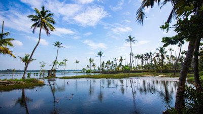 Umiam Lake, popularly known as Barapani, is a massive man-made reservoir created by damming the Umiam River in the mid-1960s. It was the first hydroelectric power project in Northeast India, but today it is better known as the region's premier destination for water sports and scenic beauty. The lake is surrounded by undulating hills covered in dense pine forests, giving it a look reminiscent of the lakes in Scotland. Spanning over 220 square kilometers in its catchment area, the lake's vast blue waters reflect the sky like a giant mirror. The Umiam Water Sports Complex is the main hub for adventure, offering everything from peaceful rowing to high-speed jet skiing. The area is a favorite for picnickers from Guwahati and Shillong, who come to enjoy the cool breeze and the panoramic views from the viewpoint. Near the lake, you will find the Lum Nehru Park, which features manicured gardens and an aviary. For those seeking a unique stay, there are houseboats and luxury resorts nestled on the islands within the lake. The lake also supports a local fishing community, and you can often see fishermen in small wooden boats at dawn. The atmosphere is a perfect blend of thrill and tranquility, making it a must-visit stop on the way to the capital. The sunrise and sunset at Umiam are particularly breathtaking, as the light plays across the water's surface and the surrounding green ridges. It is a symbol of how human engineering can coexist with natural splendor to create a world-class tourism landmark.
 @@Strategic Location and Scenic Stopover: This viewpoint is one of the most popular and accessible stops for travelers driving between Guwahati and Shillong on NH 6. Located at a strategic, slightly elevated point on the highway, it offers a quick but stunning panoramic view of the Ri-Bhoi district’s rolling hills, verdant valleys, and a glimpse of the vast plains stretching towards Assam. It serves as a literal gateway, marking the transition from the plains to the hills. @@Roadside Market and Refreshment Hub: The viewpoint often features a small cluster of tea stalls, refreshment shops, and vendors selling local fruits, vegetables (especially pineapples during the season), and indigenous artifacts. This adds a lively, commercial element to the stop, allowing visitors to stretch their legs and sample local produce. The air here is noticeably cooler than the plains below, signalling the elevation gain. @@Photography Hotspot: Due to its ease of access and wide vista, it is a prime spot for taking quick group photos and capturing the dramatic landscape. It is well-maintained and provides safety barriers for tourists to enjoy the view safely from the road edge. This location embodies the simple, natural beauty that defines the start of the Khasi and Jaintia Hills.
The Baniun Waterfall is an uncommercialized, pristine natural attraction, a lesser-known gem nestled deep within the verdant forests near Nongpoh. It is characterized by a multi-tiered cascade that plunges into a clear, tranquil pool, surrounded by dense, untouched flora. The name 'Baniun' is local, suggesting a sound or a specific geographical feature, and the spot is predominantly visited by locals or intrepid travelers seeking solitude away from crowded tourist circuits. The journey to the falls itself is an adventure, involving a short but engaging trek through thick jungle, where the air is cool, and the only sounds are the rustling leaves and the constant roar of the falling water. The falls are most spectacular during the post-monsoon months of September and October when the water flow is at its peak, transforming the cascade into a powerful curtain of white water against the dark, mossy rocks. The surrounding ecology is rich in biodiversity, showcasing the region's diverse plant and insect life, making it a perfect spot for nature enthusiasts and amateur photographers. Unlike the state's more famous waterfalls like Nohkalikai or Krangshuri, Baniun offers a sense of discovery and intimacy with nature. Visitors are encouraged to maintain the pristine environment as it remains a vital part of the local ecosystem. The large catch basin at the base of the falls forms a natural swimming hole, though caution is always advised due to unpredictable currents and rock slipperiness. The area is a fantastic representation of the raw, untamed beauty that defines the Ri-Bhoi district, serving as a reminder of the need to preserve such ecological treasures for future generations and upholding the region's nickname, the "Abode of Clouds." It provides an authentic experience of Meghalaya's deep-forested landscapes.
@@Strategic Location and Scenic Stopover: This viewpoint is one of the most popular and accessible stops for travelers driving between Guwahati and Shillong on NH 6. Located at a strategic, slightly elevated point on the highway, it offers a quick but stunning panoramic view of the Ri-Bhoi district’s rolling hills, verdant valleys, and a glimpse of the vast plains stretching towards Assam. It serves as a literal gateway, marking the transition from the plains to the hills. @@Roadside Market and Refreshment Hub: The viewpoint often features a small cluster of tea stalls, refreshment shops, and vendors selling local fruits, vegetables (especially pineapples during the season), and indigenous artifacts. This adds a lively, commercial element to the stop, allowing visitors to stretch their legs and sample local produce. The air here is noticeably cooler than the plains below, signalling the elevation gain. @@Photography Hotspot: Due to its ease of access and wide vista, it is a prime spot for taking quick group photos and capturing the dramatic landscape. It is well-maintained and provides safety barriers for tourists to enjoy the view safely from the road edge. This location embodies the simple, natural beauty that defines the start of the Khasi and Jaintia Hills.
The Baniun Waterfall is an uncommercialized, pristine natural attraction, a lesser-known gem nestled deep within the verdant forests near Nongpoh. It is characterized by a multi-tiered cascade that plunges into a clear, tranquil pool, surrounded by dense, untouched flora. The name 'Baniun' is local, suggesting a sound or a specific geographical feature, and the spot is predominantly visited by locals or intrepid travelers seeking solitude away from crowded tourist circuits. The journey to the falls itself is an adventure, involving a short but engaging trek through thick jungle, where the air is cool, and the only sounds are the rustling leaves and the constant roar of the falling water. The falls are most spectacular during the post-monsoon months of September and October when the water flow is at its peak, transforming the cascade into a powerful curtain of white water against the dark, mossy rocks. The surrounding ecology is rich in biodiversity, showcasing the region's diverse plant and insect life, making it a perfect spot for nature enthusiasts and amateur photographers. Unlike the state's more famous waterfalls like Nohkalikai or Krangshuri, Baniun offers a sense of discovery and intimacy with nature. Visitors are encouraged to maintain the pristine environment as it remains a vital part of the local ecosystem. The large catch basin at the base of the falls forms a natural swimming hole, though caution is always advised due to unpredictable currents and rock slipperiness. The area is a fantastic representation of the raw, untamed beauty that defines the Ri-Bhoi district, serving as a reminder of the need to preserve such ecological treasures for future generations and upholding the region's nickname, the "Abode of Clouds." It provides an authentic experience of Meghalaya's deep-forested landscapes. The Ri-Bhoi District Museum is a treasure trove of cultural and historical artifacts that represent the indigenous Khasi and Bhoi communities. Located within the administrative heart of Nongpoh, this museum aims to preserve the rich heritage of the district for future generations. The collection includes a wide variety of items ranging from traditional attire and jewelry to ancient agricultural tools and weapons used by tribal ancestors. One of the highlights is the display of traditional musical instruments, which tells the story of the rhythmic soul of the region. The museum also features exhibits on the unique megalithic culture of Meghalaya, showcasing miniature models of monoliths that are scattered across the hills. It serves as an educational hub for students and researchers who want to delve deep into the anthropological roots of the Ri-Bhoi people. The exhibits are curated carefully to show the evolution of the local lifestyle, from primitive forest dwelling to settled agriculture. Information plaques provide context in both English and the local dialect, making it accessible to a wide audience. The museum is not just a building of relics; it is a living testimony to the resilience and artistic spirit of the local tribes. Visiting this place gives one a profound understanding of why Meghalaya is called a cultural mosaic. It is a quiet retreat where history speaks through stones, wood, and fabric. The surrounding garden is well-maintained, offering a peaceful spot to reflect on the historical journey of the district.
@@Traditional Village Life and Landscape: Sankhat is a representative rural village in the Ri-Bhoi district, known for offering a peaceful, authentic glimpse into the traditional lifestyle of the local Bhoi tribal community. Unlike formal tourist spots, its charm lies in its simplicity: traditional houses, small terraced farms, and a community living in harmony with nature. It is a place for slow travel and cultural observation, away from the commercial tourist circuit. @@Agriculture and Water Bodies: The village is typically surrounded by lush green landscapes, small streams, or picturesque farming plots, often featuring the cultivation of betel nut, betel leaf, and seasonal crops like rice and pineapples, which form the backbone of the local economy. Visitors can observe the agricultural practices and the local methods of water management. The air is clean, and the pace of life is markedly slow and tranquil. @@Cultural Interaction Point: Visitors to Sankhat have the opportunity to interact with the local villagers, mostly belonging to the Khasi-Bhoi sub-tribe, and learn about their customs, cuisine, and the importance of the matrilineal system in their daily lives, providing a rich, immersive cultural experience that is highly educational and unique.
Mawroh Viewpoint is a popular and easily accessible stopover point near Nongpoh, strategically located along the main national highway connecting Guwahati and Shillong. It provides a spectacular, expansive panorama of the undulating hills, deep valleys, and forested expanses that characterize the transition zone of Meghalaya. The viewpoint is often the first significant natural vista encountered by travelers entering Meghalaya, earning it the title of the "Gateway Panorama." The location is designed with a safe viewing area, often featuring railings and a small platform, allowing visitors to safely admire the breathtaking landscape. On a clear day, one can see far into the distance, with the majestic Umiam Lake and the distant skyline of Shillong sometimes visible. It is particularly enchanting during sunrise and sunset, when the sky transforms into a canvas of vibrant colors, casting dramatic shadows across the rolling terrain. The viewpoint is more than just a stop for photographs; it serves as a welcome break for long-distance drivers and an introduction to the pristine environment of the Ri-Bhoi district. Small local vendors often set up stalls here, selling hot tea, instant noodles, and local snacks, adding a touch of local commerce and convenience to the tourist experience. The constant, refreshing breeze and the elevated vantage point offer an immediate sense of the cool, invigorating climate that defines the region. The view embodies the name Meghalaya (Abode of Clouds), as wisps of mist frequently drift through the valleys below, creating a truly ethereal sight. Its prominence on the national highway ensures that it is a well-maintained and important part of the state's tourism infrastructure, marking a clear boundary between the plains of Assam and the hill state of Meghalaya. It represents accessibility and grandeur, a perfect blend of natural beauty and traveler convenience, making it a compulsory stop.
Thangskai is a serene hamlet nestled in the lush foothills of the Ri-Bhoi district. This location is primarily recognized for its proximity to the Nongkhyllem Wildlife Sanctuary, making it a gateway for nature enthusiasts. The landscape is characterized by rolling green hills, dense tropical forests, and a quiet rural atmosphere that offers a stark contrast to the busy highway. Visitors often come here to experience the authentic lifestyle of the Khasi people while enjoying the untamed beauty of the Meghalayan wilderness. The area is rich in biodiversity, housing various rare bird species and small mammals that thrive in the protected environment nearby. The village itself serves as a base for trekking and exploring the lesser-known trails of the region. Local legends speak of the deep connection between the villagers and the surrounding forests, which they have protected for generations. It is a place where one can truly disconnect from the digital world and immerse themselves in the sounds of nature. The air is crisp and clean, providing a refreshing escape during the summer months. Many travelers stop here to appreciate the traditional farming practices and the vibrant orchids that grow wild along the paths. The community is welcoming, often sharing stories of their heritage with curious travelers. It is an ideal spot for those looking to explore the rural heart of Meghalaya without the crowds of major tourist hubs.Show All
@@Details of Lum Sohpetbneng Peak: Lum Sohpetbneng Peak, standing at an altitude of approximately 1,343 meters, is one of the most sacred sites in Meghalaya. Known as the "Navel of Heaven," it holds immense mythological and spiritual significance for the Khasi people. According to local legend, a golden vine bridge once connected heaven and earth at this very spot, allowing the sixteen heavenly families to traverse between worlds. Seven of these families chose to remain on earth, becoming the ancestors of the Hynniewtrep (the Khasi people). The peak is a site of pilgrimage, especially during the month of February when thousands gather for traditional rituals. Beyond its religious importance, the peak offers some of the most stunning panoramic views of the Ri Bhoi district and the distant Shillong plateau. The trek to the top is moderately challenging but rewarding, taking visitors through ancient pine groves and mist-covered ridges. The air at the summit is remarkably pure, and the silence is profound, making it an ideal spot for spiritual seekers. Historically, it has been a repository of Khasi wisdom and indigenous values, preserved through oral traditions and annual ceremonies. The peak's unique geological formation and its status as a "center of the world" in local lore make it a fascinating study for anthropologists and travelers alike. It is a place where the physical and spiritual worlds seem to converge, offering a deep sense of peace and connection to the cosmos.
The Ri-Bhoi District Museum is a treasure trove of cultural and historical artifacts that represent the indigenous Khasi and Bhoi communities. Located within the administrative heart of Nongpoh, this museum aims to preserve the rich heritage of the district for future generations. The collection includes a wide variety of items ranging from traditional attire and jewelry to ancient agricultural tools and weapons used by tribal ancestors. One of the highlights is the display of traditional musical instruments, which tells the story of the rhythmic soul of the region. The museum also features exhibits on the unique megalithic culture of Meghalaya, showcasing miniature models of monoliths that are scattered across the hills. It serves as an educational hub for students and researchers who want to delve deep into the anthropological roots of the Ri-Bhoi people. The exhibits are curated carefully to show the evolution of the local lifestyle, from primitive forest dwelling to settled agriculture. Information plaques provide context in both English and the local dialect, making it accessible to a wide audience. The museum is not just a building of relics; it is a living testimony to the resilience and artistic spirit of the local tribes. Visiting this place gives one a profound understanding of why Meghalaya is called a cultural mosaic. It is a quiet retreat where history speaks through stones, wood, and fabric. The surrounding garden is well-maintained, offering a peaceful spot to reflect on the historical journey of the district.
@@Traditional Village Life and Landscape: Sankhat is a representative rural village in the Ri-Bhoi district, known for offering a peaceful, authentic glimpse into the traditional lifestyle of the local Bhoi tribal community. Unlike formal tourist spots, its charm lies in its simplicity: traditional houses, small terraced farms, and a community living in harmony with nature. It is a place for slow travel and cultural observation, away from the commercial tourist circuit. @@Agriculture and Water Bodies: The village is typically surrounded by lush green landscapes, small streams, or picturesque farming plots, often featuring the cultivation of betel nut, betel leaf, and seasonal crops like rice and pineapples, which form the backbone of the local economy. Visitors can observe the agricultural practices and the local methods of water management. The air is clean, and the pace of life is markedly slow and tranquil. @@Cultural Interaction Point: Visitors to Sankhat have the opportunity to interact with the local villagers, mostly belonging to the Khasi-Bhoi sub-tribe, and learn about their customs, cuisine, and the importance of the matrilineal system in their daily lives, providing a rich, immersive cultural experience that is highly educational and unique.
Mawroh Viewpoint is a popular and easily accessible stopover point near Nongpoh, strategically located along the main national highway connecting Guwahati and Shillong. It provides a spectacular, expansive panorama of the undulating hills, deep valleys, and forested expanses that characterize the transition zone of Meghalaya. The viewpoint is often the first significant natural vista encountered by travelers entering Meghalaya, earning it the title of the "Gateway Panorama." The location is designed with a safe viewing area, often featuring railings and a small platform, allowing visitors to safely admire the breathtaking landscape. On a clear day, one can see far into the distance, with the majestic Umiam Lake and the distant skyline of Shillong sometimes visible. It is particularly enchanting during sunrise and sunset, when the sky transforms into a canvas of vibrant colors, casting dramatic shadows across the rolling terrain. The viewpoint is more than just a stop for photographs; it serves as a welcome break for long-distance drivers and an introduction to the pristine environment of the Ri-Bhoi district. Small local vendors often set up stalls here, selling hot tea, instant noodles, and local snacks, adding a touch of local commerce and convenience to the tourist experience. The constant, refreshing breeze and the elevated vantage point offer an immediate sense of the cool, invigorating climate that defines the region. The view embodies the name Meghalaya (Abode of Clouds), as wisps of mist frequently drift through the valleys below, creating a truly ethereal sight. Its prominence on the national highway ensures that it is a well-maintained and important part of the state's tourism infrastructure, marking a clear boundary between the plains of Assam and the hill state of Meghalaya. It represents accessibility and grandeur, a perfect blend of natural beauty and traveler convenience, making it a compulsory stop.
Thangskai is a serene hamlet nestled in the lush foothills of the Ri-Bhoi district. This location is primarily recognized for its proximity to the Nongkhyllem Wildlife Sanctuary, making it a gateway for nature enthusiasts. The landscape is characterized by rolling green hills, dense tropical forests, and a quiet rural atmosphere that offers a stark contrast to the busy highway. Visitors often come here to experience the authentic lifestyle of the Khasi people while enjoying the untamed beauty of the Meghalayan wilderness. The area is rich in biodiversity, housing various rare bird species and small mammals that thrive in the protected environment nearby. The village itself serves as a base for trekking and exploring the lesser-known trails of the region. Local legends speak of the deep connection between the villagers and the surrounding forests, which they have protected for generations. It is a place where one can truly disconnect from the digital world and immerse themselves in the sounds of nature. The air is crisp and clean, providing a refreshing escape during the summer months. Many travelers stop here to appreciate the traditional farming practices and the vibrant orchids that grow wild along the paths. The community is welcoming, often sharing stories of their heritage with curious travelers. It is an ideal spot for those looking to explore the rural heart of Meghalaya without the crowds of major tourist hubs.Show All
@@Details of Lum Sohpetbneng Peak: Lum Sohpetbneng Peak, standing at an altitude of approximately 1,343 meters, is one of the most sacred sites in Meghalaya. Known as the "Navel of Heaven," it holds immense mythological and spiritual significance for the Khasi people. According to local legend, a golden vine bridge once connected heaven and earth at this very spot, allowing the sixteen heavenly families to traverse between worlds. Seven of these families chose to remain on earth, becoming the ancestors of the Hynniewtrep (the Khasi people). The peak is a site of pilgrimage, especially during the month of February when thousands gather for traditional rituals. Beyond its religious importance, the peak offers some of the most stunning panoramic views of the Ri Bhoi district and the distant Shillong plateau. The trek to the top is moderately challenging but rewarding, taking visitors through ancient pine groves and mist-covered ridges. The air at the summit is remarkably pure, and the silence is profound, making it an ideal spot for spiritual seekers. Historically, it has been a repository of Khasi wisdom and indigenous values, preserved through oral traditions and annual ceremonies. The peak's unique geological formation and its status as a "center of the world" in local lore make it a fascinating study for anthropologists and travelers alike. It is a place where the physical and spiritual worlds seem to converge, offering a deep sense of peace and connection to the cosmos.Information
-
Why Famous:
Why Famous Place:
Horticulture Hub: Nongpoh is world-renowned for its high-quality organic pineapples and citrus fruits sold along the highway. These fruits are a staple of the local economy and a must-buy for every traveler passing through....Why Famous Place:
Horticulture Hub: Nongpoh is world-renowned for its high-quality organic pineapples and citrus fruits sold along the highway. These fruits are a staple of the local economy and a must-buy for every traveler passing through.
Sacred Peaks: The town is the gateway to Lum Sohpetbneng, a peak considered the "Navel of Heaven" by the Khasi people. It holds immense religious importance as the site where humanity is believed to have descended to earth.
: -
Architecture:
Place Architecture:
Bhoirymbong Structures: The architecture in Nongpoh reflects a transition from traditional Khasi huts to modern RCC structures. Traditional homes often feature steep pitched roofs designed to drain heavy monsoon rains eff...Place Architecture:
Bhoirymbong Structures: The architecture in Nongpoh reflects a transition from traditional Khasi huts to modern RCC structures. Traditional homes often feature steep pitched roofs designed to drain heavy monsoon rains effectively. The use of local bamboo and wood in older structures showcases the indigenous engineering skills of the Ri-Bhoi people.
Religious Landmarks: The Church of Christ in Nongpoh is a prominent architectural landmark with its gothic-inspired windows and tall spires. It stands as a symbol of the colonial influence on the region's structural design and religious landscape. The dimensions of the main hall are approximately 80x40 feet, providing a serene space for worship and community gatherings.
: -
How To Reach:
Place How to Reach:
By Air: The nearest major airport is Guwahati International Airport, located approximately 75 Kms away from Nongpoh. From the airport, one can hire a private taxi or take a shared cab heading towards Shillong to reach the... -
Near Tourist Places:
Umiam Lake (15 km), Shillong (52 km), Guwahati (50 km), Sohpetbneng (10 km), Thrills Fun Park (5 km), Lum Nehru Park (12 km), Dwar Ksuid (18 km), Nongkhyllem Sanctuary (15 km), Smit (65 km), Mawphlang (75 km).
Tourism Tips
-
Place Tourism Tips:
Health and Safety: Always carry a basic first-aid kit and any personal medications, as specialized medical facilities may be far. Be cautious while trekking on slippery paths during the rainy season and always stick to ma...
Reviews
Nongpoh Itineray And Cost:-
Information about New and Updated Locations() of Meghalaya Has Been Added :-
Card subtitle
Note:-
Information provided here in good Faith and for reference only.
All information and pictures will be updated soon, please keep visiting.
Near Places

Amlarem
Some quick example text to build on the card title and make up the bulk of the card's content.
Go somewhere
Baghmara
Some quick example text to build on the card title and make up the bulk of the card's content.
Go somewhere
Cherrapunji
Some quick example text to build on the card title and make up the bulk of the card's content.
Go somewhere
Dawki
Some quick example text to build on the card title and make up the bulk of the card's content.
Go somewhere
Jowai
Some quick example text to build on the card title and make up the bulk of the card's content.
Go somewhere
Mairang
Some quick example text to build on the card title and make up the bulk of the card's content.
Go somewhere
Mawlynnong
Some quick example text to build on the card title and make up the bulk of the card's content.
Go somewhere
Mawryngkneng
Some quick example text to build on the card title and make up the bulk of the card's content.
Go somewhere
Mawsynram
Some quick example text to build on the card title and make up the bulk of the card's content.
Go somewhere
Nongpoh
Some quick example text to build on the card title and make up the bulk of the card's content.
Go somewherein Other Cities