...

Place To Visit And Things To Do In Pavagadh

Gujarat, India
Religious Significance: Pavagadh is home to the Kalika Mata Temple, one of the 51 Shakti Peethas, where it is believed the right toe of Goddess Sati fell. The temple sits atop a volcanic hill, attracting millions of pilgrims during the Navratri festival. Historical Landscape: The hill is part of the Champaner-Pavagadh Archaeological Park, a UNESCO site that blends Hindu, Rajput, and Islamic architecture. Ruins of forts, mosques, and palaces from the 15th century dot the landscape below the shrine. Natural Beauty: The climb to the temple offers panoramic views of the Panchmahal plains and lush green forests. Visitors can choose between a challenging trek or a convenient ropeway ride to reach the summit. Spiritual Coexistence: The site uniquely hosts both a major Hindu temple and a Sufi shrine, symbolizing the cultural synthesis of the region. The volcanic rock formations and ancient water harvesting systems add to the site's mystique.

Things To Do

Card image cap
Atak Gate

@@Historical Significance and Defensive Role:@@: The Atak Gate (meaning 'Obstacle' or 'Stop') is one of the crucial, lower-level gateways marking the ...

@@Historical Significance and Defensive Role:@@: The Atak Gate (meaning 'Obstacle' or 'Stop') is one of the crucial, lower-level gateways marking the beginning of the steep ascent to the Pavagadh Fort citadel and the Kalika Mata Temple. Built primarily during the period of the Khichi Chauhan Rajputs (13th-15th century) and further fortified by the Gujarat Sultan, Mahmud Begada, after his conquest in 1484, it served as the first major line of defense for the entire fortification system. Its primary purpose was to restrict the movement of enemy forces and regulate entry into the hill fortress, a strategically vital point controlling the trade routes from Gujarat into central India. The gate is architecturally designed to be formidable, with a staggered entrance path (a pol) that breaks the momentum of an attacking army and exposes them to fire from the flanking bastions. The sheer size and solidity of the stone masonry testify to the military engineering prowess of the era. It is a historical marker that visually separates the ancient urban sprawl of Champaner at the base from the protected hill citadel of Pavagadh. This gate is not merely an entrance; it is a historical transition point, where the history shifts from the lower city's administrative and religious structures to the military and ultimate pilgrimage site at the summit. The feeling upon passing through the Atak Gate is one of stepping into a heavily fortified and ancient space. This gate, being an integral part of the Champaner-Pavagadh Archaeological Park, is a testament to the blend of Hindu and Islamic military architectural styles prevalent in the region. The gate is made of local yellow and red sandstone, reflecting the local geology and construction materials. It stands as a silent sentinel, telling the tale of sieges, conquests, and the persistent defense of the powerful Pavagadh hill. The surrounding area often contains remnants of the barracks and guard posts, emphasizing its function as a military checkpoint.
Card image cap
Champaner-Pavagadh Archaeological Park

This park is a vast expanse of history spanning from the 8th to the 16th century, representing a unique blend of Hindu and Islamic cultures. It was e...

This park is a vast expanse of history spanning from the 8th to the 16th century, representing a unique blend of Hindu and Islamic cultures. It was established as a UNESCO World Heritage site in 2004 and contains over 114 monuments including forts, palaces, religious buildings, and residential precincts. The site is famous for being the only complete and unchanged Islamic pre-Mughal city in India. It offers a glimpse into the military and agricultural structures of the regional Sultanate. The landscape is dominated by the volcanic Pavagadh Hill which rises 800 meters above the plains. Visitors can explore the unexcavated ruins that tell stories of a forgotten capital. It is a dream destination for history buffs and archaeology students.
Card image cap
Dudhiya Lake

Dudhiya Lake is one of the three sacred lakes located on the top of Pavagadh hill, alongside Chhasia and Telia lakes. The name "Dudhiya" literally tr...

Dudhiya Lake is one of the three sacred lakes located on the top of Pavagadh hill, alongside Chhasia and Telia lakes. The name "Dudhiya" literally translates to "Milky," named because of the milky white appearance of its water in ancient times. It is a perennial water source and holds great religious significance for the pilgrims visiting the Kalika Mata Temple. According to local legends, these lakes represent the three eyes of Goddess Kali. The lake is situated near the Jain temples and provides a serene environment for reflection. It was also a critical part of the ancient water management system of the hill fortress. Today, it serves as a cooling spot for trekkers reaching the summit. The atmosphere around the lake is peaceful and spiritually charged.
Card image cap
Hathni Mata Waterfall

Hathni Mata is one of the most beautiful waterfalls in Gujarat, nestled deep within the Jambughoda forest range. The name "Hathni" means "Female Elep...

Hathni Mata is one of the most beautiful waterfalls in Gujarat, nestled deep within the Jambughoda forest range. The name "Hathni" means "Female Elephant," derived from a rock at the base of the falls that resembles a baby elephant. This 100-meter-long waterfall cascades down a verdant cliff into a refreshing pool below. It is a seasonal wonder that comes to life during the monsoon, turning the entire region into a lush green paradise. The local tribal communities revere the site and have a small cave temple dedicated to the Goddess. It is a popular spot for youth and families looking for a nature escape from the city. The approach road is narrow and winds through cornfields and dense forests, offering an adventurous drive. It is a must-visit for anyone who enjoys the raw beauty of nature.
Card image cap
Jain Temples

@@Spiritual Sanctuary and Ancient Legacy:@@: The Jain Temples of Pavagadh, often collectively referred to as the Bavanderi (or Bhavanaderi) and Navala...

@@Spiritual Sanctuary and Ancient Legacy:@@: The Jain Temples of Pavagadh, often collectively referred to as the Bavanderi (or Bhavanaderi) and Navalakha groups, hold deep spiritual significance for the ?vet?mbara and Digambara Jain communities. These temples are crucial evidence of Pavagadh's long history as a major Jain pilgrimage center, with heritage tracing back as far as the 3rd century BC. The temples are primarily concentrated in three groups on the hill, with the Bavanderi group being the most prominent and accessible, located near the Naqqarkhana (Drum-house) gate on the ascent to the summit. The name Navalakha is traditionally associated with structures built with the colossal sum of nine lakh (900,000) of a currency unit, suggesting immense patronage and wealth dedicated to their construction. The existing structures are generally dated to the 14th-15th centuries CE, built under the patronage of wealthy Jain merchants and rulers, specifically during the later Chauhan Rajput period. They are dedicated to various Tirthankaras, including Suparshvanatha and Chandraprabhu. The history of these temples is closely intertwined with the Achalgacch sect of Jainism, which was established here in the 12th century AD. Despite subsequent destruction and conversion of structures during the Sultanate period, the remnants stand as powerful symbols of Jain devotion and architectural artistry. The serene atmosphere provides a stark spiritual contrast to the surrounding military ruins of the fort. These temples represent a surviving link to the multi-religious character of pre-Sultanate Pavagadh.
Card image cap
Jambughoda Wildlife Sanctuary

Established in 1990, the Jambughoda Wildlife Sanctuary covers an area of about 130 square kilometers of undulating hills and dense forest. Before ind...
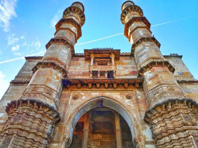
Established in 1990, the Jambughoda Wildlife Sanctuary covers an area of about 130 square kilometers of undulating hills and dense forest. Before independence, this area was part of the princely state of Jambughoda. The forest is primarily composed of Teak, Mahua, and Bamboo thickets, providing a perfect habitat for diverse wildlife. It is home to leopards, sloth bears, four-horned antelopes (Chousinghas), wild boars, and various species of snakes. The sanctuary also features two beautiful reservoirs, Kada and Targol, which attract numerous migratory birds. It is a haven for nature lovers and bird watchers. The sanctuary offers a quiet escape from the industrial noise of nearby cities. Camping at the Forest Rest House near Kada is a highlight for many visitors, offering a true "into the wild" experience under the stars.
Card image cap
Jami Masjid

The Jami Masjid of Champaner is widely considered one of the finest mosques in Western India. Built by Sultan Mahmud Begada in the late 15th century,...

The Jami Masjid of Champaner is widely considered one of the finest mosques in Western India. Built by Sultan Mahmud Begada in the late 15th century, it served as the model for later mosque architecture in the Mughal era. The structure is a stunning example of the fusion of Hindu and Islamic styles, featuring intricate stone carvings that include motifs of the Sun, lotuses, and vines. The mosque is situated just outside the royal enclosure and is elevated on a high plinth. It has a massive prayer hall with 176 pillars and multiple domes that create a grand sense of space. The courtyard is surrounded by elegant cloisters, and the entrance porches are masterpieces of craftsmanship. It is part of the UNESCO World Heritage site and remains a living testament to the artistic heights of the Gujarat Sultanate.
Card image cap
Kalika Mata Temple

@@The Ultimate Shrine and Shakti Peetha:@@: The Kalika Mata Temple is arguably the most famous and religiously significant spot in the entire Champane...

@@The Ultimate Shrine and Shakti Peetha:@@: The Kalika Mata Temple is arguably the most famous and religiously significant spot in the entire Champaner-Pavagadh Archaeological Park. It is a revered Hindu shrine dedicated to the Goddess Kali (Mahakali), believed to be one of the 51 Shakti Peethas where the right toe of Goddess Sati is said to have fallen. Dating back to the 10th-11th centuries CE, it is considered the oldest temple structure in the region. The temple holds immense historical and spiritual importance, drawing millions of pilgrims (yatris) from Gujarat and beyond throughout the year. The central image is the mukhwato (face/head) of Mahakali (painted red), flanked by the images of Kali on the right and Bahucharamata on the left. The temple's location at the very summit of the hill, offering panoramic views, adds to its ethereal and sacred atmosphere. Its history is a fascinating blend of Hindu and Jain heritage, and controversially, Islamic influence, as the dome once housed the dargah of the Sufi saint Sadan Shah Pir, a testament to the region's complex syncretic past. Following modern restoration in 2022, the shikhara (spire) was rebuilt and the dargah was respectfully relocated nearby, restoring the temple to its original, complete form after nearly 500 years. The ascent, whether by the arduous trek or the modern ropeway, is considered an act of great devotion. The temple remains a "living cultural heritage property" of the UNESCO site, constantly buzzing with activity and prayer. The temple trust diligently manages the crowds and the daily rituals, ensuring the sacred ambiance is maintained.
Card image cap
Kevada Masjid

@@Detailed History and Importance: The Kevada Masjid is a significant Islamic monument located within the Champaner-Pavagadh Archaeological Park, whic...

@@Detailed History and Importance: The Kevada Masjid is a significant Islamic monument located within the Champaner-Pavagadh Archaeological Park, which is a UNESCO World Heritage Site. Built during the 15th century under the reign of Sultan Mahmud Begada, this mosque stands as a testament to the prosperous era of the Gujarat Sultanate. It is uniquely known for its integration with the surrounding natural landscape, which was quite rare for Islamic architecture of that period. The mosque was part of a larger planned city that flourished before the capital shifted to Ahmedabad. @@Landscape Integration: Historians like Fairchild Ruggles have noted that the mosque’s placement and design seem to "reify natural forms," blending the man-made structure with the greenery of Pavagadh. This creates a serene atmosphere that differs from the more enclosed urban mosques. The site includes a prayer hall and a tomb (cenotaph) located in close proximity. @@Restoration Efforts: Over the centuries, the structure faced decay, but significant restoration was undertaken by the Archaeological Survey of India (ASI) in the late 19th century and again in 2006. Today, it remains a protected monument of national importance, attracting history buffs and architecture students who wish to study the transition of regional styles. @@Religious Context: Although it is no longer used for active worship, the mosque serves as a "living museum," representing the religious fervor and the sophisticated urban planning of the Begada era in Gujarat.
Card image cap
Khuniya Mahadev Waterfall

@@Natural Beauty and Seasonal Retreat:@@: The Khuniya Mahadev Waterfall is a natural attraction nestled within the dense, lower forested slopes of the...

@@Natural Beauty and Seasonal Retreat:@@: The Khuniya Mahadev Waterfall is a natural attraction nestled within the dense, lower forested slopes of the Pavagadh Hill. It is a seasonal waterfall that bursts into life during the heavy monsoon season (typically July to September), making it a popular local retreat during the rainy months. The name "Khuniya" suggests its hidden or secluded nature (from the word khun meaning corner/seclusion), and "Mahadev" indicates the presence of a small, ancient Shiva temple or shrine located near the base of the cascade. This site offers a stark contrast to the historical and architectural sites of the fort and temple; it is a space for nature lovers and those seeking a tranquil, green environment. The sound of the falling water, combined with the dense canopy of trees, creates a refreshing and serene atmosphere. The water collects in a small pool at the bottom, which is often used by visitors for a refreshing dip, though caution is always advised. Its existence underscores the rich biodiversity and natural hydrological systems of the Pavagadh Hill, which is part of the Jambughoda Wildlife Sanctuary area. The pilgrimage to the Mahadev shrine is a local tradition, often combined with a nature outing. The path to the waterfall is a moderate, rocky trek, adding an element of adventure to the visit, attracting younger crowds and nature photography enthusiasts. The area is part of the extensive eco-tourism efforts in the region, promoting the natural heritage alongside the historical ruins.
Card image cap
Lakulisa Temple

@@Ancient Shaivite Heritage and Ruins:@@: The Lakulisa Temple is one of the most significant and oldest surviving structures on the Pavagadh Hill, dat...

@@Ancient Shaivite Heritage and Ruins:@@: The Lakulisa Temple is one of the most significant and oldest surviving structures on the Pavagadh Hill, dating back to the 10th or 11th century CE. It is dedicated to Lakulisa, an iconic form of Lord Shiva, who is considered the founder of the Pasupata Shaivism sect. The temple is largely in ruins today, but its remnants are crucial in establishing Pavagadh's history as a major Shaivite center alongside its Jain and later Islamic heritage. Its location on the strategic Mauliya Plateau suggests it was a prominent structure before the extensive fortifications were built by the Chauhan Rajputs. The temple's ruins are protected as part of the UNESCO World Heritage Site, offering a valuable insight into the Hindu temple architecture of the Solanki period in Gujarat. The exposed carvings, surviving pillars, and the plinth of the original structure speak of a monument that was once highly ornate and grand. It is a quiet, contemplative space, far less crowded than the Kalika Mata Temple, making it an ideal spot for history buffs and those seeking authentic archaeological exploration. The temple's very existence at this strategic mid-level point reflects the power and influence of the Shaivite traditions that dominated Gujarat during the early medieval period. The site is an open-air classroom for understanding the evolution of religious architecture on the hill.
Card image cap
Lila Gumbaj ki Masjid

@@Historical Background: The Lila Gumbaj ki Masjid is another 15th-century masterpiece built by Sultan Mahmud Begada in the historical city of Champan...

@@Historical Background: The Lila Gumbaj ki Masjid is another 15th-century masterpiece built by Sultan Mahmud Begada in the historical city of Champaner. The name "Lila Gumbaj" literally translates to "Blue/Green Dome," referring to the colorful glazed tiles that once adorned its central ribbed dome. It was one of the many mosques constructed during the height of the Gujarat Sultanate's power when Champaner served as the regional capital. @@Cultural Significance: This mosque is particularly famous for its high plinth and the rhythmic arrangement of its arched openings. It reflects the peak of Indo-Islamic fusion, where local Gujarati craftsmanship met Islamic structural requirements. The mosque was strategically located near the east gate of the old city, making it a prominent landmark for travelers entering the capital. @@Architectural Conservation: Significant conservation work was conducted in 1921 and 1929 to clear ancient drains and stabilize the stone structure. The ASI continues to maintain the site, ensuring that the intricate carvings and the unique ribbed dome remain preserved for future generations. @@The Legacy of Mahmud Begada: Like its counterparts, this mosque illustrates the sultan's vision of creating a grand Islamic city. It represents a period of peace and artistic flourishing where architecture was used to project the majesty of the state. Visitors today can still feel the grandeur of the 15th-century courtly life while walking through its silent, arched corridors.
Card image cap
Nagina Masjid & Cenotaph

@@A Jewel of Architecture: Nagina Masjid, which translates to "Jewel Mosque," is widely considered one of the most exquisite structures in the Champan...

@@A Jewel of Architecture: Nagina Masjid, which translates to "Jewel Mosque," is widely considered one of the most exquisite structures in the Champaner-Pavagadh complex. Built in the late 15th century during the reign of Mahmud Begada, it is constructed primarily from pure white stone, giving it a brilliant appearance compared to the rubble masonry of other local structures. @@The Cenotaph (Mausoleum): Adjacent to the mosque stands an incredibly elegant cenotaph or tomb. This structure is famous for its open-sided design, allowing light and air to pass through while showcasing some of the finest stone carvings in all of Western India. The cenotaph serves as a memorial, likely for a high-ranking official or a member of the royal family, though the specific identity remains a subject of historical debate. @@Historical Context: The mosque is situated just south of the citadel (royal enclosure) of Champaner. Its proximity to the seat of power suggests it was a primary place of worship for the elite. The entire complex, including the mosque and the mausoleum, showcases the peak of the "Champaner style," which combined intricate floral patterns with grand structural forms. @@UNESCO Recognition: As a key component of the UNESCO World Heritage Site, Nagina Masjid is protected as a Monument of National Importance. Its white stone facade and the mathematical precision of its domes make it a primary study subject for Indo-Saracenic architecture. The mosque survives as a silent witness to the rise and fall of one of India’s most magnificent medieval capitals.
Card image cap
Navlakha Kothar

@@Medieval Storage and Strategic Supply:@@: The Navlakha Kothar (literally, 'Nine Lakh Granary/Storeroom') is a massive, ruined stone structure that o...
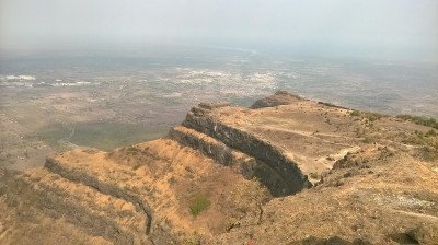
@@Medieval Storage and Strategic Supply:@@: The Navlakha Kothar (literally, 'Nine Lakh Granary/Storeroom') is a massive, ruined stone structure that once served as the primary granary and storage facility for the Pavagadh Fort citadel. Its imposing size and location on the hill emphasize the strategic military planning of the Chauhan Rajputs and later the Gujarat Sultanate under Mahmud Begada. Its purpose was to store vast quantities of grain, ammunition, and other essential supplies needed to sustain the fort's garrison and the royal court during long periods of siege, such as the 20-month siege it famously withstood before its eventual fall in 1484. The name Navlakha again denotes a colossal scale or cost, suggesting the structure was monumental and indispensable to the fort's defenses. Today, the Kothar is an evocative ruin, its thick, high walls testament to its intended function as a secure, climate-controlled storage area. Visiting the site provides a tangible connection to the logistical and defensive aspects of the medieval hilltop capital. It is a key non-religious structure within the fort, illustrating the full spectrum of urban planning: from temples to fortifications to essential civic/military architecture. The Kothar is situated on a relatively flat area of the hill slope, making it accessible but strategically positioned away from direct assault points, yet close enough to the upper citadel.
Card image cap
Pavagadh Fort

@@Fortifications of Dynasty and Conquest:@@: The Pavagadh Fort is a monumental hilltop fortress that defines the landscape of the Champaner-Pavagadh A...

@@Fortifications of Dynasty and Conquest:@@: The Pavagadh Fort is a monumental hilltop fortress that defines the landscape of the Champaner-Pavagadh Archaeological Park. Its history is one of successive dynasties, primarily the Khichi Chauhan Rajputs, who held the fort from the 13th century, and the Gujarat Sultanate under Mahmud Begada, who captured it in 1484 and established his capital nearby. The fort is a multi-layered defensive structure, strategically utilizing the natural contours of the volcanic hill, with several lines of fortification walls and gates (including Atak Gate and Budhiya Gate) extending from the base to the summit. It comprises a complex of military and administrative structures, including the upper citadel surrounding the Kalika Mata Temple, bastions, barracks, and vital water management systems (cisterns). The fort walls themselves are a masterpiece of military engineering, built to withstand prolonged sieges. The fort is not a single building but an entire fortified mountain, a UNESCO World Heritage Site, which showcases a perfect blend of pre-Mughal Hindu and Islamic military and civic architecture. Its ruins tell the story of one of the longest sieges in Indian history (20 months) and the eventual shift of power that defined the subsequent capital of Gujarat. Exploring the fort is a historical trek through battlements, watchtowers, granaries (Navlakha Kothar), and gateways, providing an immersive experience into the life and defense of a medieval city.
Card image cap
Saat Kaman

@@Military Outlook and Engineering Feat:@@: The Saat Kaman (literally, 'Seven Arches') is one of the most iconic and visually striking military remnan...

@@Military Outlook and Engineering Feat:@@: The Saat Kaman (literally, 'Seven Arches') is one of the most iconic and visually striking military remnants of the Pavagadh Fort. Situated at a critical juncture on the upper plateau, overlooking a steep ravine and offering a commanding view of the plains of Champaner, it was likely constructed as a crucial military outpost or watchtower complex during the reign of the Chauhan Rajputs and later utilized by the Sultanate. The structure consists of a series of arches (though often fewer than seven arches are fully intact today, their number can vary depending on where the counting begins and the state of preservation). These arches were designed not only for structural support but also to provide sheltered positions for guards and cannons, offering a panoramic line of fire and sight over the approaches to the fort. The architectural design is a remarkable example of stonework integrated into the hill's natural contours. The structure is a must-see for its breathtaking panoramic views of the entire archaeological park, the winding road, the Vada Talav lake, and the vast plains stretching toward Vadodara. The site is a popular rest spot on the pilgrimage route and a favorite among tourists for photography due to its dramatic setting and the aesthetic of the surviving arches. It highlights the strategic sophistication that underpinned the entire fort's defense.
Card image cap
Teliya Talav

Teliya Talav is a significant historical and religious water body located on the Mauliya plateau of the Pavagadh hill in Gujarat. This ancient reserv...

Teliya Talav is a significant historical and religious water body located on the Mauliya plateau of the Pavagadh hill in Gujarat. This ancient reservoir is one of the three famous tanks on the hill, along with Dudhiya Talav and Chhashiya Talav, which are symbolically associated with milk, buttermilk, and oil. The name "Teliya" is derived from the Gujarati word for oil, as the water in this lake is said to have an oily appearance or consistency due to the presence of specific minerals or spiritual beliefs. Historically, this lake played a crucial role in the water management system of the Champaner-Pavagadh Archaeological Park, a UNESCO World Heritage Site. It was part of an ingenious network of macro and micro catchments designed by ancient engineers to harvest rainwater on the volcanic hill slopes, ensuring a steady water supply for the garrison and pilgrims throughout the year. The lake is situated near the Sadan Shah Gate and the famous Suparshvanath Digamber Jain Temple, making it a pivotal stop for devotees ascending toward the Mahakali Temple. Legend suggests that the waters of these three lakes represent the three primary humors or essential liquids, and bathing or visiting them is considered spiritually purifying. Surrounded by rugged volcanic rocks and sparse vegetation, the lake offers a tranquil environment away from the main temple crowds. It serves as a testament to the advanced hydraulic engineering of the Solanki and Chauhan dynasties who fortified this hill. Over the centuries, the lake has witnessed the rise and fall of various empires, from the Rajput kings to Sultan Mahmud Begada. Today, it remains a serene spot where nature meets history, providing a reflective space for visitors to appreciate the natural beauty of the Panchmahal district. The lake's surface often reflects the clear blue sky and the surrounding ancient ruins, creating a picturesque setting that captures the essence of Pavagadh's spiritual and architectural heritage.
Card image cap
Virasat Van

@@Eco-Tourism and Cultural Interpretation:@@: Virasat Van (literally, 'Heritage Forest') is a relatively newer addition to the Pavagadh landscape, dev...

@@Eco-Tourism and Cultural Interpretation:@@: Virasat Van (literally, 'Heritage Forest') is a relatively newer addition to the Pavagadh landscape, developed as an eco-tourism park and a space for cultural and historical interpretation of the Champaner-Pavagadh Archaeological Park. It is situated at the foothills, providing a green, manicured, and educational space distinct from the rugged ruins on the hill. The park serves multiple purposes: it acts as a green buffer zone for the UNESCO site, helps in the conservation of local flora, and provides a gentle, accessible park experience for families and those unable to climb the hill. Its design often incorporates landscaped gardens, walking trails, information boards detailing the history of the various monuments on the hill, and statues or models that explain the ecology and architecture of the area. It is a place to relax, learn about the site before or after a climb, and appreciate the natural heritage of the region. The focus on local tree species and medicinal plants adds an educational dimension, connecting the history of the fort to its natural environment. It's a quiet, shaded respite from the heat, offering a refreshing end to a day of historical exploration. The park actively promotes awareness about the UNESCO status and the importance of preserving both the cultural and natural heritage of Pavagadh.
Show All

Note:-

Information provided here in good Faith and for reference only.

All information and pictures will be updated soon, please keep visiting.

Near Places
...
Ahmedabad

Some quick example text to build on the card title and make up the bulk of the card's content.

Go somewhere
...
Bhuj

Some quick example text to build on the card title and make up the bulk of the card's content.

Go somewhere
...
Chotila

Some quick example text to build on the card title and make up the bulk of the card's content.

Go somewhere
...
Dahod

Some quick example text to build on the card title and make up the bulk of the card's content.

Go somewhere
...
Dandi

Some quick example text to build on the card title and make up the bulk of the card's content.

Go somewhere
...
Kevadia

Some quick example text to build on the card title and make up the bulk of the card's content.

Go somewhere
...
Kutch

Some quick example text to build on the card title and make up the bulk of the card's content.

Go somewhere
...
Lothal

Some quick example text to build on the card title and make up the bulk of the card's content.

Go somewhere
...
Mandvi

Some quick example text to build on the card title and make up the bulk of the card's content.

Go somewhere
...
Modhera

Some quick example text to build on the card title and make up the bulk of the card's content.

Go somewhere
in Other Cities