


Midway Viewpoint
General information
-
Ideal Duration:
30 to 60 MinutesPlace Type:
Nature & TransitEntry Fees:
Entry Fee Details: There is absolutely no entry fee to access the Midway Viewpoint as it is a public roadside amenity. Parking is also free, though it is requested to park responsibly along the highway shoulder. If you choose to use the restroom facilities at the nearby pr...Entry Fee Details: There is absolutely no entry fee to access the Midway Viewpoint as it is a public roadside amenity. Parking is also free, though it is requested to park responsibly along the highway shoulder. If you choose to use the restroom facilities at the nearby private stalls, a small fee of 10-20 INR may be expected. Buying local produce from the vendors is the best way to support the site. :Timing:
Regular Timings: Accessible 24/7, but best visited between 6:00 AM and 5:00 PM.
Ideal Visit Time: Sunset (4:30 PM to 5:15 PM) is the most magical time. Early mornings (7:00 AM) are best for seeing the clouds in the valley. The months of Oc...Regular Timings: Accessible 24/7, but best visited between 6:00 AM and 5:00 PM.
Ideal Visit Time: Sunset (4:30 PM to 5:15 PM) is the most magical time. Early mornings (7:00 AM) are best for seeing the clouds in the valley. The months of October and November offer the clearest skies after the monsoon wash. :Special Events:
The Migratory Bird Season (Nov-Dec): While not a formal event, the passage of Amur Falcons and other migratory birds can sometimes be observed from this height, creating a natural spectacle for bird lovers. Local village youths sometimes set up small "Nature Awareness" stal...The Migratory Bird Season (Nov-Dec): While not a formal event, the passage of Amur Falcons and other migratory birds can sometimes be observed from this height, creating a natural spectacle for bird lovers. Local village youths sometimes set up small "Nature Awareness" stalls during the peak tourist months of December to educate travelers about the local ecology. :Best Photo Spots:
The Ridge Edge: Standing near the stone parapet with the deep valley behind you creates an amazing sense of scale.
The Mist Backdrop: On foggy days, the diffused light is perfect for moody, atmospheric portraits.The Ridge Edge: Standing near the stone parapet with the deep valley behind you creates an amazing sense of scale.
The Mist Backdrop: On foggy days, the diffused light is perfect for moody, atmospheric portraits.
Fruit Stalls: The colorful displays of wild fruits and the local vendors in their traditional shawls make for excellent cultural shots. :Photo Gallery
Things To Do
-
Landscape Photography: Capture the infinite layers of blue and green mountains.
Bird Watching: Use binoculars to spot high-altitude birds and migratory species.
Local Food Tasting: Try wild apples, passion fruit, and traditional "sticky rice" cakes sold at the stalls.
Picnicking: Enjoy a quick meal in the eco-shelters with a view.
Stretching & Relaxation: Use the fresh air to rejuvenate during a long road trip.
Cloud Gazing: Watch the dramatic movement of mist and clouds through the valley.
Botanical Interest: Observe the wild ferns and orchids growing along the cliff edges. :...Landscape Photography: Capture the infinite layers of blue and green mountains.
Bird Watching: Use binoculars to spot high-altitude birds and migratory species.
Local Food Tasting: Try wild apples, passion fruit, and traditional "sticky rice" cakes sold at the stalls.
Picnicking: Enjoy a quick meal in the eco-shelters with a view.
Stretching & Relaxation: Use the fresh air to rejuvenate during a long road trip.
Cloud Gazing: Watch the dramatic movement of mist and clouds through the valley.
Botanical Interest: Observe the wild ferns and orchids growing along the cliff edges. :
Information
-
Why Famous:
The Cloud Sea Phenomenon: Famous for the "Sea of Clouds" that often settles in the valley below during early mornings, making the mountains look like islands. It is also famous as a Birding Hotspot, where one can often see predatory birds like eagles and hawks soaring at ey...The Cloud Sea Phenomenon: Famous for the "Sea of Clouds" that often settles in the valley below during early mornings, making the mountains look like islands. It is also famous as a Birding Hotspot, where one can often see predatory birds like eagles and hawks soaring at eye level. For locals, it is a famous "Tea Stop" where the quality of wild-grown local oranges and seasonal fruits is highly praised. : -
Architecture:
Highway Rest-Stop Architecture: The viewpoint features a series of "Eco-Shelters" built by the Nagaland Tourism Department. These are open-sided pavilions with concrete bases and green-painted tin roofs, measuring about 15x15 feet each. The design is minimal to not distrac...Highway Rest-Stop Architecture: The viewpoint features a series of "Eco-Shelters" built by the Nagaland Tourism Department. These are open-sided pavilions with concrete bases and green-painted tin roofs, measuring about 15x15 feet each. The design is minimal to not distract from the view. Low stone parapets run along the edge of the cliff for safety, built with local mountain rock. Small wooden stalls nearby use traditional "thatch-and-bamboo" styles for a rustic look. : -
How To Reach:
By Air: Dimapur Airport is the entry point; hire a taxi towards Wokha via Kohima.
By Train: Dimapur Station is the nearest rail connection.
By Road: It is located directly on NH-2. From Tuophema, drive tow...By Air: Dimapur Airport is the entry point; hire a taxi towards Wokha via Kohima.
By Train: Dimapur Station is the nearest rail connection.
By Road: It is located directly on NH-2. From Tuophema, drive towards Wokha for about 20-30 minutes.
By Local Transport: Any bus or shared taxi traveling between Kohima and Wokha or Mokokchung will pass this point. : -
Weather and Best Time to Visit:
Winter (Oct-Feb): Best for long-distance views and sunsets.
Monsoon (July-Sept): Best for the "Mist and Clouds" experience, though roads can be tricky.
Summer (March-May): Pleasant breeze and clear blue skie...Winter (Oct-Feb): Best for long-distance views and sunsets.
Monsoon (July-Sept): Best for the "Mist and Clouds" experience, though roads can be tricky.
Summer (March-May): Pleasant breeze and clear blue skies.
Time of Day: Late afternoon is the peak for color, while early morning is best for atmospheric fog. : -
Near Tourist Places:
1. Tiyi Mountain (15 KMS), 2. Doyang Dam (25 KMS), 3. Wokha Town (20 KMS), 4. Tuophema Village (15 KMS), 5. Kohima (26 KMS), 6. Sendenyu (10 KMS), 7. Botsa (5 KMS), 8. Nerhema (12 KMS), 9. Gariphema (18 KMS), 10. Chiephobozou (10 KMS)
Tourism Tips
-
Health & Safety: The viewpoint is on a high cliff; do not cross the safety barriers.
Packing: A windcheater or light jacket is essential as it is always breezy.
Accommodation: Best to stay in Tuophema or Ko...Health & Safety: The viewpoint is on a high cliff; do not cross the safety barriers.
Packing: A windcheater or light jacket is essential as it is always breezy.
Accommodation: Best to stay in Tuophema or Kohima; no overnight stay at the viewpoint.
Cash & Connectivity: Keep small change for fruit vendors; no ATMs nearby. Mobile signal is surprisingly good due to the height.
Travel Note: The road can be winding; carry motion sickness medicine if needed. :
Reviews
FAQs
Tuophema Itineray And Cost:-
Midway Viewpoint Tourism:-
Other Places In Tuophema :-
Other States In India :-
Information about New and Updated Locations() of Nagaland Has Been Added :-
Card subtitle
Note:-
Information provided here in good Faith and for reference only.
Near Places
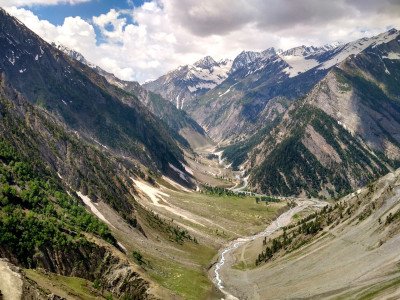
Dzukou Valley Trek Start
Some quick example text to build on the card title and make up the bulk of the card's content.
Go somewhere
Ketsiezou Watch Tower
Some quick example text to build on the card title and make up the bulk of the card's content.
Go somewhere
Kisama Heritage Village
Some quick example text to build on the card title and make up the bulk of the card's content.
Go somewhere
Naga Heritage Village Replica
Some quick example text to build on the card title and make up the bulk of the card's content.
Go somewhere
Nerhema Starting Point
Some quick example text to build on the card title and make up the bulk of the card's content.
Go somewhere
Puliebadze Peak
Some quick example text to build on the card title and make up the bulk of the card's content.
Go somewhere
Sakhabama Community Reserve
Some quick example text to build on the card title and make up the bulk of the card's content.
Go somewhere
Seiterhaphe Memorial Site
Some quick example text to build on the card title and make up the bulk of the card's content.
Go somewhere
Sendenyu Biodiversity Wildlife Sanctuary
Some quick example text to build on the card title and make up the bulk of the card's content.
Go somewhere
Tuophema Tourist Village
Some quick example text to build on the card title and make up the bulk of the card's content.
Go somewhere
Zhadima Village
Some quick example text to build on the card title and make up the bulk of the card's content.
Go somewherein Other Cities