

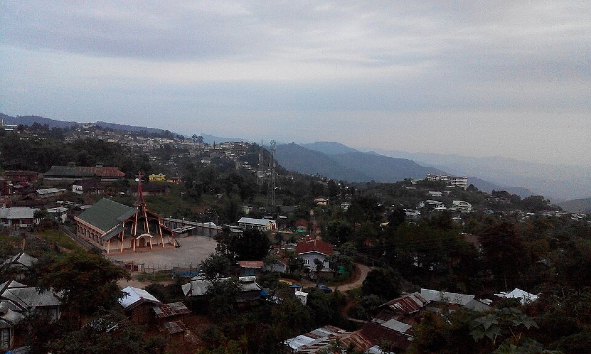
Mount Tiyi
General information
-
Ideal Duration:
4 to 6 Hours (Full trek)Place Type:
Natural/Spiritual/Adventure TourismEntry Fees:
General Entry and Viewing Fees: There is typically No Entry Fee required for the mountain itself, as it is a protected natural resource and not a commercial park. This encourages community and nature tourism.
Trekking Permit/Local Fees: Whi...General Entry and Viewing Fees: There is typically No Entry Fee required for the mountain itself, as it is a protected natural resource and not a commercial park. This encourages community and nature tourism.
Trekking Permit/Local Fees: While the government doesn't charge, local village councils might impose a small, voluntary, or mandatory fee for trekking permits or for the maintenance of the trails, which is generally a minimal amount, perhaps Rs.50 to Rs.200 per person.
Cost of Local Guide: A local guide is highly recommended, costing between Rs.500 and Rs.1500, depending on the trek length and negotiation. Investing in a guide is a payment towards safety, local knowledge, and supporting the local economy.Timing:
Regular Timings: The mountain is technically open 24 hours, as it is a natural landscape, but for trekking, the suggested time is from 6:00 AM to 5:00 PM to ensure safe return before dark. Overnight stays are possible only with prior local permission and proper camping gear...Regular Timings: The mountain is technically open 24 hours, as it is a natural landscape, but for trekking, the suggested time is from 6:00 AM to 5:00 PM to ensure safe return before dark. Overnight stays are possible only with prior local permission and proper camping gear.
Ideal Visit Time: Start the trek very early, around 6:00 AM or 7:00 AM, to avoid the midday sun and to maximize the chance of clear, haze-free views from the summit, which are often best right after sunrise.Special Events:
Lotha Christian Conventions: Given the strong Christian faith in Nagaland, large religious conventions or gatherings organized by the Lotha Baptist Church often take place at or near the base of the mountain in nearby compounds, attracting thousands of worshippers and offeri...Lotha Christian Conventions: Given the strong Christian faith in Nagaland, large religious conventions or gatherings organized by the Lotha Baptist Church often take place at or near the base of the mountain in nearby compounds, attracting thousands of worshippers and offering a powerful display of community faith.
Annual Mountain Climb/Race: Sometimes, local adventure clubs organize an annual competitive mountain climb or trail running event to the peak to promote fitness and tourism, turning the peaceful trail into a temporary, high-energy sports venue.Best Photo Spots:
The summit offers the best panoramic view, but the trails have their own charm.
The Summit Panorama: The best spot for a sweeping 360-degree shot, especially ideal for capturing the wide expanse of the Doyang River and the surrounding Naga Hills, is right at the hig...The summit offers the best panoramic view, but the trails have their own charm.
The Summit Panorama: The best spot for a sweeping 360-degree shot, especially ideal for capturing the wide expanse of the Doyang River and the surrounding Naga Hills, is right at the highest point of the mountain, where the view is unobstructed.
Rhododendron Trail Frame: During the blooming season (October to March), look for a spot on the trail where the colorful rhododendrons can naturally frame a shot of the valley below or of the mountain itself, creating a harmonious blend of foreground color and background majesty.
The Sunrise/Sunset Point: Any clear vantage point slightly below the summit, facing the direction of the sunrise (East) or sunset (West), is perfect for capturing the dramatic light and cloud formations, especially for creating silhouette shots against the vibrant sky.Photo Gallery
Things To Do
-
Conquering the Summit Trek: Undertake the full trek to the 1,969. 91-meter summit, a physically challenging and rewarding activity that is the primary reason for a visit, offering a sense of achievement and unparalleled views.
Sunset and Sunrise Viewing: Plan a visit or a guided overnight camp (with necessary permits and safety measures) to witness the spectacular sunrise or sunset, where the light transforms the distant plains and valleys into a canvas of vibrant colors.
Bird-Watching and Ecology Study: Spend time observing the forest's vibrant ecosystem. The dense cover is a habitat for numerous bird species endemic to the Northeast, making it a wonderful spot for a quiet nature study.
Cultural Interaction and Folklore Hearing: Engage with local Lotha villager...Conquering the Summit Trek: Undertake the full trek to the 1,969. 91-meter summit, a physically challenging and rewarding activity that is the primary reason for a visit, offering a sense of achievement and unparalleled views.
Sunset and Sunrise Viewing: Plan a visit or a guided overnight camp (with necessary permits and safety measures) to witness the spectacular sunrise or sunset, where the light transforms the distant plains and valleys into a canvas of vibrant colors.
Bird-Watching and Ecology Study: Spend time observing the forest's vibrant ecosystem. The dense cover is a habitat for numerous bird species endemic to the Northeast, making it a wonderful spot for a quiet nature study.
Cultural Interaction and Folklore Hearing: Engage with local Lotha villagers before or after the trek to hear the authentic legends and folklore associated with the 'Hidden Orchard' and the mountain's spiritual status.
Photography of Natural Landscapes: Capture the grand scale of the mountain, the lush greenery, and the distant valleys. The clear air and high altitude are excellent for crisp landscape shots.
Exploration of Wildflowers: Depending on the season, search for the beautiful wild rhododendrons and other endemic mountain flowers, which are scattered across the slopes and trails.
Seeking the 'Mountain of Life' Springs: With a local guide, locate one of the pure natural spring water sources, a symbolic act that connects you directly to the mountain's life-giving essence.
Information
-
Why Famous:
Mount Tiyi is widely famous for its striking elevation and its deep cultural and spiritual significance to the local Lotha community.
Highest Peak and Panoramic Views: Its status as the highest mountain in the Wokha district guarantees breathtaking, expansive views ...Mount Tiyi is widely famous for its striking elevation and its deep cultural and spiritual significance to the local Lotha community.
Highest Peak and Panoramic Views: Its status as the highest mountain in the Wokha district guarantees breathtaking, expansive views of the region and beyond. The opportunity to witness the sunrise and sunset from this altitude is a major attraction, offering an unparalleled visual experience for photographers and nature lovers.
Lotha Naga Folklore and Sacred Status: The mountain’s legendary association with the "hidden orchard" and the "abode of departed souls" imbues it with a sense of mysticism and makes it a focal point of the local Lotha cultural heritage, drawing visitors interested in spiritual and ethnographic tourism. -
Architecture:
Natural Geological Structure and Composition: Mount Tiyi is a natural, towering mountain peak, and its 'architecture' is geological—formed over millennia by tectonic activity and erosion, rather than human construction. It is composed primarily of the ancient, hard rock f...Natural Geological Structure and Composition: Mount Tiyi is a natural, towering mountain peak, and its 'architecture' is geological—formed over millennia by tectonic activity and erosion, rather than human construction. It is composed primarily of the ancient, hard rock formations characteristic of the Patkai range, offering a natural buttress against the elements. Its structural integrity is a feature of its sheer mass and height.
Summit Features and Trails: At the peak, the 'architecture' is minimal, focusing on viewing convenience, often featuring natural flat rock surfaces or a small, maintained clearing for tourists to rest and admire the view. The trekking trails leading up are the main human 'interventions,' designed to be functional, albeit rugged. These trails, which can extend for several kilometers, are a complex network of steps, hand-hewn paths, and cleared forest lines. Dimensions are highly variable, with the mountain's circumference extending for tens of kilometers, and the main trails varying in width from 1 to 2 meters. -
How To Reach:
By Air: The nearest airport is Dimapur Airport (DMU), approximately 125 km away. From the airport, hire a pre-paid taxi or a shared Sumo/taxi to Wokha town. The journey takes about 4 to 5 hours. From Wokha, local transport or a taxi is needed for the short drive (approx. ...By Air: The nearest airport is Dimapur Airport (DMU), approximately 125 km away. From the airport, hire a pre-paid taxi or a shared Sumo/taxi to Wokha town. The journey takes about 4 to 5 hours. From Wokha, local transport or a taxi is needed for the short drive (approx. 10-15 km) to the base village of the trekking trail.
By Train: The nearest railway station is Dimapur Railway Station (DMU). From Dimapur, take a shared or reserved taxi to Wokha town. From the town, hire a local taxi to the starting point of the trek.
By Road: Wokha is well-connected by road to Kohima (75 km) and Dimapur. State buses and private taxis are readily available. Once in Wokha, the base of the trek is a short drive via local taxis, which are the most convenient way to reach the trail entrance.
By Local Transport: Reserved local taxis (Sumo, Bolero) are the most reliable way to travel from Wokha town to the trailhead and for waiting during the trek. Shared taxis might be available to the nearby villages but not directly to the remote starting point. -
Weather and Best Time to Visit:
Different Types of Seasons: The period from October to March is the undisputed best time to visit Mount Tiyi. This encompasses the post-monsoon and winter seasons, characterized by clear skies, excellent visibility, and cold but ideal temperatures for a strenuous trek. The...Different Types of Seasons: The period from October to March is the undisputed best time to visit Mount Tiyi. This encompasses the post-monsoon and winter seasons, characterized by clear skies, excellent visibility, and cold but ideal temperatures for a strenuous trek. The blooming of rhododendrons adds to the visual appeal during these months. Avoid the heavy Monsoon season (June to September) due to potential landslides and dangerously slippery, muddy trails.
Different Parts of the Day: As a trekking destination, the Morning is the most crucial part of the day, as a full trek requires several hours. Starting early ensures the summit is reached while the views are clearest and the sun is not at its most intense. -
Near Tourist Places:
Doyang Hydro Project (approx. 25 km), Morashen View Point (approx. 15 km), Totsu Cliff (approx. 20 km), Vankhosung Baptist Church (approx. 5 km), Water Pool at Vankhosung (approx. 5 km), Baghty Valley (approx. 35 km), Liphanyan Governor's Camp (approx. 40 km), Wokha Museum (approx. 10 km), Wokha Town Center (approx. 10-15 km), Dimapur (approx. 125 km).
Tourism Tips
-
Health & Safety: Due to the altitude and challenging trail, physical fitness is required. Wear layered clothing to adjust to changing temperatures. Carry sufficient water and high-energy snacks. Inform your accommodation or local contacts about your trekking plans.Health & Safety: Due to the altitude and challenging trail, physical fitness is required. Wear layered clothing to adjust to changing temperatures. Carry sufficient water and high-energy snacks. Inform your accommodation or local contacts about your trekking plans.
Packing: Essential packing includes a sturdy backpack, high-grip trekking boots, a rain jacket (even outside monsoon), and a fully charged power bank, as phone signal can be intermittent. A headlamp or flashlight is crucial for any unexpected delays.
Accommodation: Homestays in the villages surrounding the mountain base offer a more authentic experience than staying in Wokha town, allowing for an early start to the trek. Book in advance, especially during the peak tourist season of November and December.
Respecting Local Culture: As the mountain is spiritually sacred to the Lotha tribe, maintain silence in certain areas, do not disturb the natural setting, and seek permission before attempting to camp or deviate from the main trail.
Reviews
FAQs
Wokha Itineray And Cost:-
Other Places In Wokha :-
Other States In India :-
Information about New and Updated Locations() of Nagaland Has Been Added :-
Card subtitle
Note:-
Information provided here in good Faith and for reference only.
Near Places
Baghty Valley
Some quick example text to build on the card title and make up the bulk of the card's content.
Go somewhere
Bonchu Community Reserve
Some quick example text to build on the card title and make up the bulk of the card's content.
Go somewhere
Changpang Community Reserve
Some quick example text to build on the card title and make up the bulk of the card's content.
Go somewhere
Doyang Hydro Project & Reservoir
Some quick example text to build on the card title and make up the bulk of the card's content.
Go somewhere
Doyang River
Some quick example text to build on the card title and make up the bulk of the card's content.
Go somewhere
Doyang View Point
Some quick example text to build on the card title and make up the bulk of the card's content.
Go somewhere
Liphanyan Governor's Camp
Some quick example text to build on the card title and make up the bulk of the card's content.
Go somewhere
Lotsu Community Reserve
Some quick example text to build on the card title and make up the bulk of the card's content.
Go somewhere
Morashen View Point
Some quick example text to build on the card title and make up the bulk of the card's content.
Go somewhere
Mount Tiyi Trekking Trail
Some quick example text to build on the card title and make up the bulk of the card's content.
Go somewhere
Phodong Resort & Recreation Center
Some quick example text to build on the card title and make up the bulk of the card's content.
Go somewhere
Pongidong Village
Some quick example text to build on the card title and make up the bulk of the card's content.
Go somewhere
Pyotchu Community Reserve
Some quick example text to build on the card title and make up the bulk of the card's content.
Go somewhere
Totsu Cliff
Some quick example text to build on the card title and make up the bulk of the card's content.
Go somewhere
Totsu Wozhu Lake
Some quick example text to build on the card title and make up the bulk of the card's content.
Go somewhere
Vankhosung Baptist Church
Some quick example text to build on the card title and make up the bulk of the card's content.
Go somewherein Other Cities