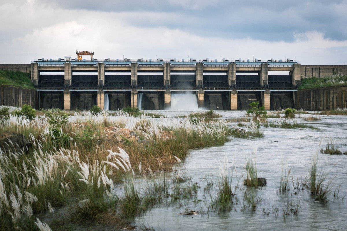
Chungthang Dam
General information
-
Ideal Duration:
1 - 2 Hours (Observation Only):Place Type:
Industrial Heritage & Engineering Marvel:Entry Fees:
Industrial Observation & Permits: There is technically no entry fee for observing the dam from public viewpoints along the road, as it is a working industrial site, but access to the core dam structure, the powerhouse, or the project premises is strictly forbidden and requir...Industrial Observation & Permits: There is technically no entry fee for observing the dam from public viewpoints along the road, as it is a working industrial site, but access to the core dam structure, the powerhouse, or the project premises is strictly forbidden and requires specialized, high-level government or company authorization;
Security Fee and Permit Costs: The indirect cost is the mandatory Inner Line Permit (ILP) for Indian nationals and the Protected Area Permit (PAP) for foreigners to enter North Sikkim, which typically costs around INR 50 to 100 per person processed through registered travel agents, covering the entire North Sikkim region, including Chungthang itself, but this is a regional charge, not a direct entrance fee for the dam;
Guide Service Cost: Hiring a local registered guide or taxi driver for the North Sikkim circuit, which is often mandatory, accounts for the main expense, ensuring compliance with local regulations and safety, often ranging from INR 15,000 to 25,000 for a full North Sikkim tour.
:Timing:
Regular Timings: Public viewing is generally possible during daylight hours, typically from 6:00 AM to 5:00 PM, subject to local security restrictions and road conditions, which can change rapidly;
Ideal Visit Time - Morning Light: The early...Regular Timings: Public viewing is generally possible during daylight hours, typically from 6:00 AM to 5:00 PM, subject to local security restrictions and road conditions, which can change rapidly;
Ideal Visit Time - Morning Light: The early morning (around 8:00 AM to 10:00 AM) is the ideal time to visit for optimal viewing and photography, as the sun illuminates the valley floor and the dam structure, minimizing the afternoon haze and maximizing light quality for capturing the scale of the project;
Seasonal Timings: During the harsh Winter months (December to February), access can be highly restricted or entirely impossible due to heavy snowfall and icy road conditions, so travelers must confirm local road status before setting out.
:Special Events:
Inauguration Ceremony: The only truly special events were the official milestones related to the project's development, such as the initial reservoir filling in September 2016 and the final commissioning ceremony in February 2017, which were major state and national events; ...Inauguration Ceremony: The only truly special events were the official milestones related to the project's development, such as the initial reservoir filling in September 2016 and the final commissioning ceremony in February 2017, which were major state and national events;
GLOF Remembrance: Post-2023, the anniversary of the flash floods serves as an informal time of remembrance for those affected by the disaster, often marked by quiet local prayers and reflection, though no public celebration is held;
Engineer’s Day Visits: Periodically, the project organizes special technical visits for engineering students or professionals, which are closed to the public but represent a major event for the technical community.
:Best Photo Spots:
The Main Viewing Gallery: The best spot is the designated roadside viewpoint where the scale of the 60-meter structure and the surrounding construction site is clearly visible, offering a panoramic frame of the entire project complex;
Downstream...The Main Viewing Gallery: The best spot is the designated roadside viewpoint where the scale of the 60-meter structure and the surrounding construction site is clearly visible, offering a panoramic frame of the entire project complex;
Downstream River Viewpoint: A less direct, but powerful spot is further downstream where the water returns to the Teesta, capturing the force of the released water juxtaposed with the serene flow of the river before the powerhouse was damaged;
Roadside Bends Above the Site: Certain bends on the road leading up to Lachen or Lachung from Chungthang offer elevated, wide-angle views of the dam site nestled in the valley, providing an excellent landscape perspective of the concrete and rockfill structure against the vast mountain canvas;
The Confluence Area Perspective: While not the dam itself, the confluence point offers a dynamic foreground (Teesta's birth) with the dam structure visible in the background, symbolizing the human-nature interface.
:Photo Gallery
Things To Do
-
Viewing the Massive Scale of Construction: The primary activity is viewing the large-scale infrastructure from designated, safe viewing points near the periphery, marveling at the engineering required to tame the mighty Teesta River;
Understanding Hydro Power: Visitors can engage in self-guided learning about run-of-the-river schemes, clean energy, and the complexities of power generation in the mountains, making it an educational stop;
Geopolitical Significance Observation: Given the proximity to the international border, observing the strategic presence of the Indian Army and the security protocols provides insight into the geopolitical importance of North Sikkim and the dam's role as a critical national asset;
Photography of the Infrastructure Contrast: Captur...Viewing the Massive Scale of Construction: The primary activity is viewing the large-scale infrastructure from designated, safe viewing points near the periphery, marveling at the engineering required to tame the mighty Teesta River;
Understanding Hydro Power: Visitors can engage in self-guided learning about run-of-the-river schemes, clean energy, and the complexities of power generation in the mountains, making it an educational stop;
Geopolitical Significance Observation: Given the proximity to the international border, observing the strategic presence of the Indian Army and the security protocols provides insight into the geopolitical importance of North Sikkim and the dam's role as a critical national asset;
Photography of the Infrastructure Contrast: Capturing the dramatic contrast between the massive, grey concrete and rockfill structures of the dam against the backdrop of the verdant, towering Himalayan peaks and the confluence nearby offers a unique photographic theme that blends nature with industrial development;
Local Community Interaction for Context: Seeking permission to briefly interact with local business owners or residents (outside restricted zones) can provide a richer, human perspective on the dam's controversial history, its impact on livelihoods, and the displacement issues, offering a deeper travel experience beyond the physical structure;
Future Reconstruction Monitoring: For visitors in the coming years, the site offers a unique opportunity to witness the vast scale of reconstruction efforts, if they proceed, providing a real-time view of mega-infrastructure recovery and geotechnical challenges in action;
Environmental Impact Awareness: Dedicating time to understand the local flora and fauna that thrive despite the project, and discussing conservation efforts with local guides, adds an important ecological dimension to the visit, moving beyond simple sightseeing to comprehensive environmental awareness, encouraging responsible tourism behavior and promoting respect for the fragile mountain environment, thereby enhancing the overall travel value of the location substantially.
:
Information
-
Why Famous:
Strategic National Importance: The dam is famous primarily for being one of India's largest hydroelectric power projects in the Northeast, capable of generating 1200 MW of clean energy, which is vital for the region's energy security and economic development, despite the sig...Strategic National Importance: The dam is famous primarily for being one of India's largest hydroelectric power projects in the Northeast, capable of generating 1200 MW of clean energy, which is vital for the region's energy security and economic development, despite the significant environmental opposition it faces;
A Symbol of Disaster and Resilience: Following the devastating 2023 GLOF event, the dam gained international notoriety as a symbol of the extreme vulnerability of Himalayan infrastructure to climate change-induced natural disasters, leading to widespread discussions about appropriate dam design and placement in seismically active and glacially influenced regions.
: -
Architecture:
Key Structural Specifications: The Teesta III HEP is characterized by a 60-meter high Concrete Faced Rockfill Dam (CFRD), designed to manage the turbulent flow of the river and create a reservoir for the run-of-the-river scheme; the architecture includes sophisticated water...Key Structural Specifications: The Teesta III HEP is characterized by a 60-meter high Concrete Faced Rockfill Dam (CFRD), designed to manage the turbulent flow of the river and create a reservoir for the run-of-the-river scheme; the architecture includes sophisticated water diversion systems, specifically two massive de-silting basins, each measuring approximately 17m in width, 23m in height, and 320m in length, designed to manage the high sediment load characteristic of Himalayan rivers before the water enters the conveyance system;
Water Conveyance & Powerhouse Dimension: Water is routed through a primary Head Race Tunnel (HRT) which is 14. 3 kilometers long with a 7. 5-meter diameter, leading to a large, circular surge shaft which is 15. 5 meters in diameter and approximately 160 meters high, providing protection against water hammer effects; the underground powerhouse is a massive cavern containing six Pelton turbine-generator units, each rated at 200 MW, totaling the massive 1200 MW capacity, followed by a 1. 2 km long tailrace tunnel measuring 8. 2m x 8. 0m that returns the water back to the Teesta River near Sankalan, completing the loop of this complex engineering feat.
: -
How To Reach:
By Air (Nearest Airport): The nearest airport is Bagdogra Airport (IXB) in Siliguri, West Bengal, located approximately 175 KMS away from Chungthang, necessitating a substantial six to eight-hour taxi journey through winding mountain roads;
By T...By Air (Nearest Airport): The nearest airport is Bagdogra Airport (IXB) in Siliguri, West Bengal, located approximately 175 KMS away from Chungthang, necessitating a substantial six to eight-hour taxi journey through winding mountain roads;
By Train (Nearest Railway Station): The closest major railhead is New Jalpaiguri (NJP), also in Siliguri, West Bengal, situated roughly 176 KMS from Chungthang, requiring passengers to hire a full-day private or shared taxi service from the station for the final leg of the journey;
By Road (Main Access): The journey to Chungthang involves navigating the national highways connecting Siliguri to Gangtok (about 100 KMS away) and then proceeding north through Mangan; the road is often difficult, prone to landslides, and takes approximately five to seven hours to cover the 95 KMS stretch from Gangtok, making the drive a scenic but arduous commitment;
By Local Transport (Permit & Shared Taxis): Shared Jeep or Tata Sumo services are available, primarily from Gangtok or Mangan, and these are the most common public transport modes, requiring the necessary ILP/PAP permits to be produced at checkposts like Toong, about 11 KMS from Chungthang, with booking being essential due to limited frequency and capacity.
: -
Weather and Best Time to Visit:
Seasonal Preference: The Spring and Autumn months (March to June and September to November) are the best times to visit, as they offer clear skies, stable road conditions, and pleasant temperatures for travel, with April and October being particularly ideal for enjoying comf...Seasonal Preference: The Spring and Autumn months (March to June and September to November) are the best times to visit, as they offer clear skies, stable road conditions, and pleasant temperatures for travel, with April and October being particularly ideal for enjoying comfortable weather;
Monsoon & Winter Avoidance: The Monsoon season (July and August) should generally be avoided due to extremely heavy rainfall, which frequently triggers landslides, causes road closures, and significantly increases travel time and risk in the region;
Ideal Parts of the Day for Viewing: The mid-morning (after the early chill but before the afternoon haze) provides the best visibility of the dam structure and surrounding valley, while the late afternoon offers dramatic, deep shadows that highlight the rugged terrain, but travelers must ensure they leave the region before sunset due to visibility concerns on the mountain roads.
: -
Near Tourist Places:
Lachen (29 KMS), Lachung (23 KMS), Gurudongmar Lake (105 KMS), Yumthang Valley (49 KMS), Mangan (28 KMS), Thangu Valley (70 KMS), Phuni Valley (35 KMS), Green Lake Trek Base (50 KMS), Bhim Nala Falls (15 KMS), Singhik Viewpoint (45 KMS):
Tourism Tips
-
Health & Safety - Altitude and Roads: Visitors must take precautions against Acute Mountain Sickness (AMS) despite Chungthang's relatively lower altitude compared to Lachen and Lachung, and must strictly adhere to road safety warnings, as the mountain roads are narrow, windi...Health & Safety - Altitude and Roads: Visitors must take precautions against Acute Mountain Sickness (AMS) despite Chungthang's relatively lower altitude compared to Lachen and Lachung, and must strictly adhere to road safety warnings, as the mountain roads are narrow, winding, and prone to landslides, especially during the monsoon;
Packing Essentials: Essential packing items include warm layered clothing suitable for cold temperatures (even in Summer), waterproof outer layers, sturdy hiking shoes, and basic emergency medication;
Accommodation: Since the dam is an industrial site, accommodation is not directly available, but tourists can find small guesthouses and homestays in the main Chungthang town center or nearby villages, although most travelers prefer to stay in Lachen or Lachung;
Permit Protocol: It is absolutely mandatory to arrange and carry the Inner Line Permit (ILP) or Protected Area Permit (PAP) documentation, photocopies of ID and address proof, and recent passport-size photos, as these documents are required for check-in at all major security posts like Toong and cannot be obtained spontaneously at the site;
Responsible Tourism & Local Etiquette: Due to the dam's controversial and fragile status, visitors should refrain from engaging in any disruptive behavior, including unauthorized photography inside restricted areas, and should maintain respect for the local Lepcha communities and their environmental concerns.
:
Reviews
FAQs
Chungthang Itineray And Cost:-
Other Places In Chungthang :-
Other States In India :-
Information about New and Updated Locations() of Sikkim Has Been Added :-
Card subtitle
Note:-
Information provided here in good Faith and for reference only.
Near Places
Bhewma Falls
Some quick example text to build on the card title and make up the bulk of the card's content.
Go somewhere
Bhim Nala Falls
Some quick example text to build on the card title and make up the bulk of the card's content.
Go somewhere
Chungthang
Some quick example text to build on the card title and make up the bulk of the card's content.
Go somewhere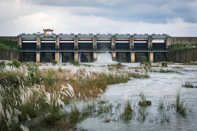
Chungthang Dam
Some quick example text to build on the card title and make up the bulk of the card's content.
Go somewhere
Chungthang Dam View Point
Some quick example text to build on the card title and make up the bulk of the card's content.
Go somewhere
Chungthang Monastery
Some quick example text to build on the card title and make up the bulk of the card's content.
Go somewhere
Gurudwara Nanak Lama Chungthang
Some quick example text to build on the card title and make up the bulk of the card's content.
Go somewhere
Kabi Lungchok
Some quick example text to build on the card title and make up the bulk of the card's content.
Go somewhere
Lachen Viewpoint
Some quick example text to build on the card title and make up the bulk of the card's content.
Go somewhere
Naga Falls
Some quick example text to build on the card title and make up the bulk of the card's content.
Go somewhere
Naga Waterfall
Some quick example text to build on the card title and make up the bulk of the card's content.
Go somewhere
Phodong Monastery
Some quick example text to build on the card title and make up the bulk of the card's content.
Go somewhere
River Confluence
Some quick example text to build on the card title and make up the bulk of the card's content.
Go somewhere
Thangu Valley
Some quick example text to build on the card title and make up the bulk of the card's content.
Go somewhere
Thangu Village
Some quick example text to build on the card title and make up the bulk of the card's content.
Go somewhere
The Holy Rock and Paddy Field
Some quick example text to build on the card title and make up the bulk of the card's content.
Go somewherein Other Cities