

Deomali Peak
General information
-
Ideal Duration:
6 to 8 HoursPlace Type:
Adventure & NatureSpecial Events:
Parab Festival: A district-wide tribal festival in November often features events near the foothills.
Winter Trekking Meet: Organized by local clubs in January. ...Parab Festival: A district-wide tribal festival in November often features events near the foothills.
Winter Trekking Meet: Organized by local clubs in January.Best Photo Spots:
Photo Spots:
The Milestone: The official "Highest Peak" stone. Viewpoint 1: Overlooking the winding ghat roads.
The Sunset Ridge: The western face during the golden hour. ...Photo Spots:
The Milestone: The official "Highest Peak" stone. Viewpoint 1: Overlooking the winding ghat roads.
The Sunset Ridge: The western face during the golden hour.Photo Gallery
Things To Do
-
Summit Trekking: Walk the final stretch to the highest point marker.
Photography: Capture the "sea of clouds" during early morning hours.
Camping: Set up a tent near the nature camp for a wilderness experience.
Birding: Look for the Malabar Whistling Thrush in the canopy.
Tribal Village Visit: Visit the base villages to see traditional mountain farming.
Star Gazing: The clear high-altitude sky is perfect for identifying constellations.
Landscape Painting: A favorite spot for artists due to the layered mountain views.
Paragliding: Occasionally organized during winter festivals. ...Summit Trekking: Walk the final stretch to the highest point marker.
Photography: Capture the "sea of clouds" during early morning hours.
Camping: Set up a tent near the nature camp for a wilderness experience.
Birding: Look for the Malabar Whistling Thrush in the canopy.
Tribal Village Visit: Visit the base villages to see traditional mountain farming.
Star Gazing: The clear high-altitude sky is perfect for identifying constellations.
Landscape Painting: A favorite spot for artists due to the layered mountain views.
Paragliding: Occasionally organized during winter festivals.
Information
-
Why Famous:
Highest Point: It is the crown of Odisha’s geography.
Trekking Destination: Known for its moderate difficulty trails that attract adventure seekers. ...Highest Point: It is the crown of Odisha’s geography.
Trekking Destination: Known for its moderate difficulty trails that attract adventure seekers. -
Architecture:
Eco-Cottages: The new accommodation units are built using sustainable materials to blend with the landscape.
Dimension: The peak rises to 5,485 feet above sea level. The summit ridge is about 2 KM long. ...Eco-Cottages: The new accommodation units are built using sustainable materials to blend with the landscape.
Dimension: The peak rises to 5,485 feet above sea level. The summit ridge is about 2 KM long. -
How To Reach:
By Air: Visakhapatnam (170 KM).
By Train: Koraput (60 KM).
By Road: Hire a sturdy SUV from Koraput as the ghat roads are steep.
By Local Transport: No direct buses; privat...By Air: Visakhapatnam (170 KM).
By Train: Koraput (60 KM).
By Road: Hire a sturdy SUV from Koraput as the ghat roads are steep.
By Local Transport: No direct buses; private hire is the only reliable option. -
Weather and Best Time to Visit:
Winter: October to March is the peak season.
Monsoon: July to August for the best cloud effects, but roads are risky.
Morning: Pre-dawn to 10:00 AM. ...Winter: October to March is the peak season.
Monsoon: July to August for the best cloud effects, but roads are risky.
Morning: Pre-dawn to 10:00 AM. -
Near Tourist Places:
Galigabadar (15 KM), Damanjodi (35 KM), Koraput (62 KM), Pottangi (25 KM), Tribal Museum (63 KM), Kolab Dam (70 KM), Sunabeda (50 KM), Maliguda (75 KM), Jeypore (85 KM), Duduma (110 KM).
Tourism Tips
-
Health: Carry medicines for motion sickness due to hairpin bends.
Packing: Heavy woolens are a must; temperatures can drop to 5°C.
Cash: No ATMs within 30 KM; carry sufficient cash.
Read MoreHealth: Carry medicines for motion sickness due to hairpin bends.
Packing: Heavy woolens are a must; temperatures can drop to 5°C.
Cash: No ATMs within 30 KM; carry sufficient cash.
Connectivity: Very poor network at the summit; inform family beforehand.Reviews
FAQs
Koraput Itineray And Cost:-
Other Places In Koraput :-
Other States In India :-
Information about New and Updated Locations() of Odisha Has Been Added :-
Card subtitle
Note:-
Information provided here in good Faith and for reference only.
Near Places

Balda Cave
Some quick example text to build on the card title and make up the bulk of the card's content.
Go somewhere
Damanjodi Township
Some quick example text to build on the card title and make up the bulk of the card's content.
Go somewhere
Deomali Peak
Some quick example text to build on the card title and make up the bulk of the card's content.
Go somewhere
Duduma Waterfall
Some quick example text to build on the card title and make up the bulk of the card's content.
Go somewhere
Galigabadar Waterfall
Some quick example text to build on the card title and make up the bulk of the card's content.
Go somewhere
Nandapur Batrisa Singhasan
Some quick example text to build on the card title and make up the bulk of the card's content.
Go somewhere
Palmetum Park
Some quick example text to build on the card title and make up the bulk of the card's content.
Go somewhere
Pandi Picnic Spot
Some quick example text to build on the card title and make up the bulk of the card's content.
Go somewhere
Punjisil Waterfalls
Some quick example text to build on the card title and make up the bulk of the card's content.
Go somewhere
Putsil Table Mountain
Some quick example text to build on the card title and make up the bulk of the card's content.
Go somewhere
Raisil Perennial Stream
Some quick example text to build on the card title and make up the bulk of the card's content.
Go somewhere
Rani Duduma Waterfalls
Some quick example text to build on the card title and make up the bulk of the card's content.
Go somewhere
Rathibali Waterfall
Some quick example text to build on the card title and make up the bulk of the card's content.
Go somewhere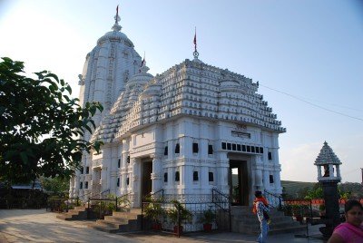
Sabar Srikhetra Jagannath Temple
Some quick example text to build on the card title and make up the bulk of the card's content.
Go somewhere
Sabara Srikhetra
Some quick example text to build on the card title and make up the bulk of the card's content.
Go somewhere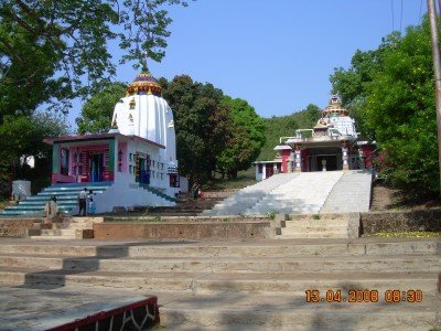
Sunabeda Township
Some quick example text to build on the card title and make up the bulk of the card's content.
Go somewherein Other Cities