

Asurghati Waterfall
General information
-
Ideal Duration:
4-5 hours (Excluding Travel Time)Place Type:
Natural Waterfall, Picnic Spot, TrekkingEntry Fees:
No Official Fee (Natural Site): There is no formal entry fee to visit the natural waterfall site itself, as it is a remote natural attraction and not a commercially maintained park.
Local Guide and Parking Fees: Visitors should budget for sm...No Official Fee (Natural Site): There is no formal entry fee to visit the natural waterfall site itself, as it is a remote natural attraction and not a commercially maintained park.
Local Guide and Parking Fees: Visitors should budget for small, informal parking fees if designated spots are used, which may be managed by local villagers, generally ranging from Rs.20 to Rs.50 per vehicle. Permit and Sanctuary Fee (If part of a larger reserve): While the waterfall is outside the core zone, if the entry route requires traversing any designated forest/eco-tourism buffer zone or a private road maintained by a local council, a minimal environmental or road toll fee might be applicable, typically under Rs.100 per person. This fee contributes to local road and environment maintenance and is not a formal 'entry ticket' but a community contribution.Timing:
Regular Timings: 8:00 AM to 6:
00 PM (Daylight Hours): Visitors are advised to strictly adhere to daylight hours, as the remote, forested area is unsafe after sunset due to wildlife and poor road conditions.
Ideal...Regular Timings: 8:00 AM to 6:
00 PM (Daylight Hours): Visitors are advised to strictly adhere to daylight hours, as the remote, forested area is unsafe after sunset due to wildlife and poor road conditions.
Ideal Visit Time: Late Morning to Early Afternoon (11:00 AM - 3:00 PM) This window allows for comfortable travel, ample time for trekking and picnicking, and utilizes the brightest sunlight for photography.
Peak Season Timings: During the peak tourist season (November to February), the base area gets slightly crowded around noon, so an early start is recommended for solitude.
Monsoon Window: The very end of the monsoon season (September-October) offers the maximum water flow, making it the most visually stunning time, though the trek path can be slippery and challenging, requiring extra caution.Special Events:
Post-Monsoon Festival Celebrations: While no major annual festival is held directly at the falls, the post-monsoon period (October-November) sees an increased number of locals celebrating informal picnic gatherings, often coinciding with local harvest or tribal festivals, wh...Post-Monsoon Festival Celebrations: While no major annual festival is held directly at the falls, the post-monsoon period (October-November) sees an increased number of locals celebrating informal picnic gatherings, often coinciding with local harvest or tribal festivals, which creates a vibrant, communal atmosphere distinct from the rest of the year.
Nature Photography Workshops: Occasionally, local tourism or nature clubs organize weekend photography or trekking workshops at the site due to its natural beauty, which can draw a small, enthusiastic crowd.
Tribal Gatherings: The surrounding forested area is significant to several local tribes; small, traditional gatherings or rituals might be observed at the site throughout the year, especially during auspicious days.Best Photo Spots:
The Spiral Trek Vista: The viewpoint achieved at the end of the short spiral path provides the most encompassing and photogenic view of the entire cascade framed by the dense jungle.
Rock Face Close-Up: Capturing the water as it fans out and...The Spiral Trek Vista: The viewpoint achieved at the end of the short spiral path provides the most encompassing and photogenic view of the entire cascade framed by the dense jungle.
Rock Face Close-Up: Capturing the water as it fans out and hits the rugged, moss-covered rock face, emphasizing the texture and force of the flow.
Sunlight Through the Canopy: Photographing the way the morning or late afternoon sun pierces the dense tree cover, creating dramatic rays of light (crepuscular rays) over the waterfall's pool.
The Misty Base Pool: Capturing the hazy, serene atmosphere at the bottom of the falls where the water collects, often resulting in long-exposure shots for a silky water effect.Photo Gallery
Things To Do
-
Photography and Nature Shots: Engage in capturing the seasonal water flow, the lush greenery, and the misty atmosphere; focus on macro shots of native flora and the texture of the rocks.
Trekking and Exploration: Undertake the short, adventurous trek up the spiral ghat road to reach the highest visible viewpoint of the cascade, experiencing the jungle's raw feel and varied terrain.
Picnicking and Relaxation: Utilize the naturally flat areas near the base stream for a peaceful family or group picnic; enjoy the sound of the falling water and the cool, fresh air of the forest.
Birdwatching and Wildlife Spotting: Spend quiet time observing the surrounding trees for local and migratory bird species; keep an eye out for smaller jungle animals.
Read MorePhotography and Nature Shots: Engage in capturing the seasonal water flow, the lush greenery, and the misty atmosphere; focus on macro shots of native flora and the texture of the rocks.
Trekking and Exploration: Undertake the short, adventurous trek up the spiral ghat road to reach the highest visible viewpoint of the cascade, experiencing the jungle's raw feel and varied terrain.
Picnicking and Relaxation: Utilize the naturally flat areas near the base stream for a peaceful family or group picnic; enjoy the sound of the falling water and the cool, fresh air of the forest.
Birdwatching and Wildlife Spotting: Spend quiet time observing the surrounding trees for local and migratory bird species; keep an eye out for smaller jungle animals.
Meditation and Wellness: The secluded and naturally soothing environment is perfect for quiet meditation, deep breathing exercises, or a rejuvenating digital detox away from city noise.
Local Cuisine Tasting: While amenities are limited, try to arrange for a packed meal featuring local Odia delicacies from Baripada or Rairangpur to enjoy in the natural setting.
Ecological Education: Take the opportunity to learn about the unique ecology of the Eastern Ghats, including the types of trees, rock formations, and the impact of the monsoon on the regional water cycle. This adds an educational layer to the scenic trip.
Sunset Viewing: On the return journey, stop at a high point on the ghat road to witness the breathtaking sunset over the Mayurbhanj landscape, a spectacular close to the day's adventure.
Stream Dipping: Carefully dip your feet in the cool stream at the waterfall's base, especially on a hot day, ensuring safety and adherence to any local guidelines.
Nature Journaling: Carry a notebook and sketch or write about the surroundings, documenting the colors, sounds, and sensations of the forest and the waterfall.
Rock Climbing (Minor): Explore the low-lying, stable rocks for minor, safe rock-climbing practice under close supervision to add a physical challenge.
Information
-
Why Famous:
Post-Monsoon Flow and Tranquility: It is famous for its relatively secluded location and the stunning, powerful flow of water immediately following the monsoon season (September to November). Unlike more accessible spots, Asurghati retains a profound sense of tranquility, a...Post-Monsoon Flow and Tranquility: It is famous for its relatively secluded location and the stunning, powerful flow of water immediately following the monsoon season (September to November). Unlike more accessible spots, Asurghati retains a profound sense of tranquility, attracting those who specifically seek peace away from crowds. The journey through the hilly, forested ghat road is also a key attraction, offering a mini-adventure. The panoramic view from the top of the short trek path is exceptionally rewarding, providing a vantage point to appreciate the dense surrounding forest and the cascading water below. This combination of a challenging but short trek, the peaceful jungle setting, and the seasonal rush of water makes it a unique attraction in the Mayurbhanj region. The location has also become known as an excellent spot for family and friend picnics due to the clean, naturally formed areas near the stream, allowing for quiet feasting and relaxation amidst nature's raw beauty, differentiating it from structured park settings. -
Architecture:
Natural Cascade Formation: The architecture is purely natural, defined by the geological features of the rock strata in the region. The water descends over a series of rugged rocks, creating a multi-tiered cascade rather than a single vertical drop.
Read MoreNatural Cascade Formation: The architecture is purely natural, defined by the geological features of the rock strata in the region. The water descends over a series of rugged rocks, creating a multi-tiered cascade rather than a single vertical drop.
Pathway and Viewpoint Dimensions: The natural 'architecture' includes the small ghat road and the spiral way to the top. The surrounding forest canopy forms a natural enclosure, enhancing the sense of seclusion. The approximate vertical drop height of the visible cascade is relatively small, perhaps between 15 and 20 meters, flowing into a shallow pool. The catchment area for the stream feeds from the higher reaches of the nearby hills. The rocks are typically coarse-grained granite and metamorphic rock, which resist erosion, forming the steep cliffs over which the water falls. The natural trekking path to the viewpoint is estimated to be about 500 meters in length, offering varied elevation changes that constitute a mini-trek. This natural setting lacks man-made architectural structures, focusing entirely on preserving the pristine environment. The entire visible area of the waterfall and its base pool might span an area of approximately 200 square meters. The surrounding jungle acts as the grand hall of this natural monument, its ceiling reaching up to 25-30 meters high due to the towering trees.How To Reach:
By Air: The nearest airport is Biju Patnaik International Airport (BBI) in Bhubaneswar, approximately 297 KMS from the waterfall site. From Bhubaneswar, hire a pre-booked taxi or take a train/bus to Baripada, then proceed with local transport.
...By Air: The nearest airport is Biju Patnaik International Airport (BBI) in Bhubaneswar, approximately 297 KMS from the waterfall site. From Bhubaneswar, hire a pre-booked taxi or take a train/bus to Baripada, then proceed with local transport.
By Train: The nearest major railway station is Baripada Railway Station (BPR), approximately 94 KMS away from the picnic spot. From the station, the best option is to hire a dedicated 4x4 or a large taxi/cab for the remaining journey, as the last stretch is through rough terrain/ghat roads. An alternative, but less direct, option is Rairangpur Railway Station, which is only 18 KMS away, but train connectivity to Rairangpur is limited.
By Road: Baripada is well-connected by National Highway 18 (NH 18). From Baripada, take a vehicle towards Rairangpur. The drive of about 98 KMS will involve transitioning from the main highway onto smaller, semi-paved, and forested ghat roads for the final leg of the journey, requiring a robust vehicle. Local bus service is available up to Rairangpur, from where a local taxi or auto-rickshaw must be hired.
By Local Transport: From Baripada, shared jeeps or larger auto-rickshaws are generally not advisable for the full 98 KMS trip due to the remoteness and road quality. Hiring a full-day private taxi or cab is the safest and most comfortable local transport option, allowing for flexibility and safe navigation of the ghat sections.Weather and Best Time to Visit:
Different Types of Seasons:
Winter Season (November to February): The absolute best time to visit. The air is cool and pleasant, the humidity is low, and the water flow is respectable, especially if you visit closer to November. The environ...Different Types of Seasons:
Winter Season (November to February): The absolute best time to visit. The air is cool and pleasant, the humidity is low, and the water flow is respectable, especially if you visit closer to November. The environment is ideal for trekking and picnicking without the intensity of the sun.
Monsoon Season (July to October): The peak water flow is seen at the end of the monsoon (September/October), making it visually spectacular. However, the roads can be slippery, the trek can be muddy, and heavy rains can make travel unpredictable.
Summer Season (March to June): The water flow is minimal or non-existent, and the high temperatures make the long road trip and trekking uncomfortable and tiring.
Different Parts of the Day: Early Morning (7:00 AM - 10:00 AM) Ideal for photographers, birdwatchers, and experiencing the untouched serenity before any crowds arrive; provides the coolest temperature for the trek. Mid-Day (11:00 AM - 2:00 PM) Best for general visitors and picnickers, as the road is fully visible and the sun ensures the surrounding area is dry and safe for exploration. Late Afternoon (3:00 PM - 5:00 PM) A good time for a final, brief visit or for the return drive, with pleasant lighting and cooler temperatures starting to set in.Near Tourist Places:
Similipal National Park (Core Zone - ~150 KMS), Badjod Dam (~88 KMS), Khiching Temple (~140 KMS), Barehipani Waterfall (~140 KMS), Joranda Waterfall (~140 KMS), Baripada Museum (~98 KMS), Belgadia Chak (~99 KMS), Rairangpur Town (~23 KMS), Ramateertha (~110 KMS), Lulung Picnic Spot (~130 KMS)Tourism Tips
-
Health & Safety: Carry a comprehensive first-aid kit, insect repellent, and wear sturdy, non-slip shoes for the trek. Do not attempt to swim in the pool, especially during high flow, as hidden currents and slippery rocks pose a major risk. Always inform locals or your hote...Health & Safety: Carry a comprehensive first-aid kit, insect repellent, and wear sturdy, non-slip shoes for the trek. Do not attempt to swim in the pool, especially during high flow, as hidden currents and slippery rocks pose a major risk. Always inform locals or your hotel of your travel plans and expected return time.
Packing: Pack plenty of drinking water (the journey is long and amenities are minimal), packaged snacks/picnic items, a light rain jacket (even outside monsoon), sunscreen, a hat, and a power bank for your mobile phone (network connectivity can be patchy). Carry a garbage bag to ensure a strict 'leave no trace' policy.
Accommodation: Since the spot is remote, plan to stay in Baripada or Rairangpur. Baripada offers a wider range of hotels, lodges, and guesthouses. Book accommodation in advance, especially during the peak tourist season of November to January.
Other Different Topics Heading:
Vehicle Choice: Hire a vehicle with good ground clearance (SUV/Jeep) as the final stretch of road is unpaved and through the ghats.
Local Interaction: Be respectful of the local tribal communities and their environment; avoid loud music and littering.
Photography Ethics: Always seek permission before photographing any local residents.
Reviews
FAQs
Baripada Itineray And Cost:-
Asurghati Waterfall Tourism:-
Other Places In Baripada :-
Other States In India :-
Information about New and Updated Locations() of Odisha Has Been Added :-
Card subtitle
Note:-
Information provided here in good Faith and for reference only.
Near Places
Aarikulo Dam
Some quick example text to build on the card title and make up the bulk of the card's content.
Go somewhere
Asurghati Waterfall
Some quick example text to build on the card title and make up the bulk of the card's content.
Go somewhere
Badjod Dam
Some quick example text to build on the card title and make up the bulk of the card's content.
Go somewhere
Bagdiha Chhaka
Some quick example text to build on the card title and make up the bulk of the card's content.
Go somewhere
Baripada Museum
Some quick example text to build on the card title and make up the bulk of the card's content.
Go somewhere
Belgadia Chak
Some quick example text to build on the card title and make up the bulk of the card's content.
Go somewhere
Belgadia Palace
Some quick example text to build on the card title and make up the bulk of the card's content.
Go somewhere
Bhimkund Waterfall
Some quick example text to build on the card title and make up the bulk of the card's content.
Go somewhere
Budha Balanga Bridge
Some quick example text to build on the card title and make up the bulk of the card's content.
Go somewhere
Chaulabhaja Waterfall
Some quick example text to build on the card title and make up the bulk of the card's content.
Go somewhere
Deuli Dam
Some quick example text to build on the card title and make up the bulk of the card's content.
Go somewhere
Devkund Ambika Temple
Some quick example text to build on the card title and make up the bulk of the card's content.
Go somewhere
Haripur Garh
Some quick example text to build on the card title and make up the bulk of the card's content.
Go somewhere
Jagannath Temple
Some quick example text to build on the card title and make up the bulk of the card's content.
Go somewhere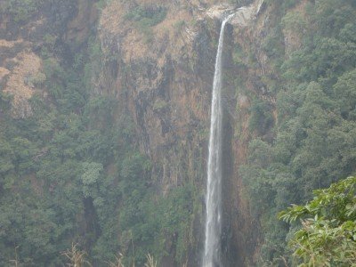
Joranda Waterfall
Some quick example text to build on the card title and make up the bulk of the card's content.
Go somewhere
Jwalamukhi Temple
Some quick example text to build on the card title and make up the bulk of the card's content.
Go somewherein Other Cities