Chadwa Dam
General information
-
Ideal Duration:
2 to 3 hours (For a peaceful visit, stroll, and photography) up to 4 to 5 hours (For a full picnic, dedicated birdwatching session, and relaxation).Place Type:
Dam, Reservoir, Picnic Spot, Birdwatching DestinatEntry Fees:
General Access and Parking Fees: Typically, access to the immediate dam area and the public road along the crest is Free of Cost. However, there might be a nominal, small charge for two-wheeler and four-wheeler Parking levied by local village committees or authorized contra...General Access and Parking Fees: Typically, access to the immediate dam area and the public road along the crest is Free of Cost. However, there might be a nominal, small charge for two-wheeler and four-wheeler Parking levied by local village committees or authorized contractors. This fee is generally inexpensive, ranging from INR 10 to INR 30 per vehicle. This is to manage vehicle traffic and provide basic security.
Fees for Organized Activities: For organized activities, such as setting up a large picnic tent or a bonfire area for a big group, local management might charge a small, non-official fee. This is usually determined on the spot. In the rare case of authorized Boating (if available), there will be a separate, per-person or per-boat charge, likely in the range of INR 50 to INR 100.
Photography/Videography Permits: For commercial photography, such as film shooting or large-scale video projects, a formal permit from the local Irrigation Department or District Administration is likely required, incurring a significant fee. Casual, handheld camera or mobile phone photography is entirely free for all tourists.Timing:
Regular Timings: Open All Day (6:00 AM to 7:00 PM) The Chadwa Dam is essentially a functional public water body and road, meaning there are no strict official gates that close the area. It is generally considered Open from dawn, around 6:00 AM, until early evening, around 7...Regular Timings: Open All Day (6:00 AM to 7:00 PM) The Chadwa Dam is essentially a functional public water body and road, meaning there are no strict official gates that close the area. It is generally considered Open from dawn, around 6:00 AM, until early evening, around 7:00 PM. Visitors should plan to leave before dark, as the area can be isolated and lacks extensive lighting.
Ideal Visit Time:
The Golden Hours and Winter Afternoons: The Ideal Visit Time is during the winter season (November to March). Within the day, the Early Morning (6:00 AM to 9:00 AM) is perfect for birdwatching, tranquil jogging, and catching the beautiful sunrise with its gentle, soft light. The Late Afternoon (4:00 PM to 6:00 PM) is best for general relaxation, enjoying the cool breeze, and capturing the spectacular sunset. Visiting during the hot midday hours should be avoided due to the intense sun and heat.Special Events:
The Arrival of Winter Migrants Festival (Informal): While not a formal government-organized festival, the arrival of migratory birds in late October and November is considered a special, informal seasonal event by local nature lovers and birdwatchers. This period marks the ...The Arrival of Winter Migrants Festival (Informal): While not a formal government-organized festival, the arrival of migratory birds in late October and November is considered a special, informal seasonal event by local nature lovers and birdwatchers. This period marks the transformation of the dam into a vibrant avian paradise, attracting all the special interest groups. Local birding groups often organize dedicated trips and awareness camps to welcome and observe the new arrivals, marking the unofficial start of the winter tourist season.
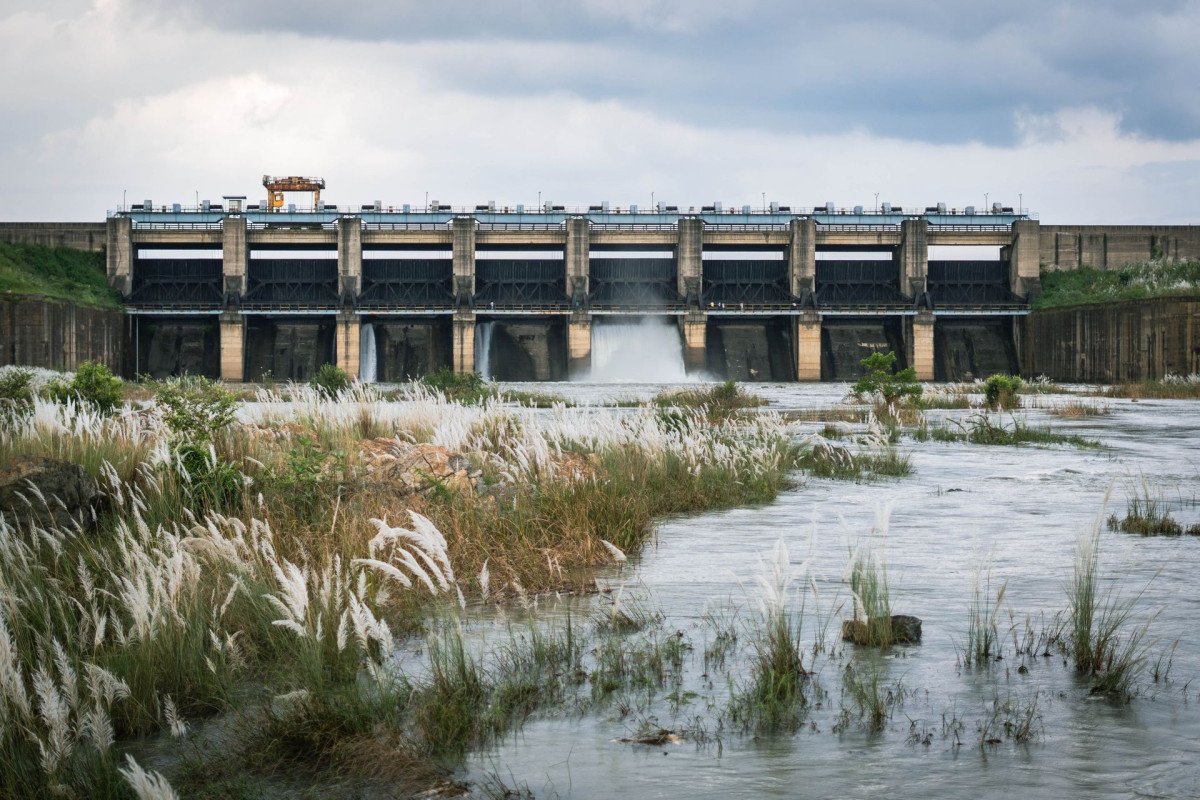
Monsoon Spillway Opening (Seasonal Event): The dramatic and rare event of the sluice gates of the concrete spillway being opened to release excess water during intense monsoon downpours is a spectacular and localized event. When the dam reaches its 'red level,' the sight of the cascading water is a powerful display of nature's force and engineering control, drawing a crowd of local spectators, though it is usually a public safety measure.
New Year's Day and Winter Picnic Season: The peak of the winter picnic season, especially on New Year's Day (January 1st), is the biggest annual congregation at the dam. Families travel from across the district and neighboring areas to celebrate, turning the tranquil spot into a lively, joyous hub of celebration.Best Photo Spots:
The Dam Embankment Crest:
Panoramic Views: The top of the main earthen embankment offers the most panoramic and wide-angle view of the entire reservoir, the concrete spillway, and the surrounding hills. This spot is ideal for landscape photo...The Dam Embankment Crest:
Panoramic Views: The top of the main earthen embankment offers the most panoramic and wide-angle view of the entire reservoir, the concrete spillway, and the surrounding hills. This spot is ideal for landscape photography to capture the vastness of the water and the horizon line, especially during the dramatic sunset or sunrise.
The Vulture Roosting Trees (Birding Spots): Identify the large, often dry or tall trees on the less-disturbed side of the reservoir (often the far bank). These are where the rare vultures and other large birds are likely to perch. This location is best for wildlife photography, requiring a long lens and patience.
The Sunset Reflection Point: Position yourself on the eastern bank of the dam in the late afternoon. As the sun begins its descent in the west, the calm water surface reflects the orange and pink hues of the sky, creating a stunning mirror image effect. This spot is a must for capturing the most aesthetic and tranquil pictures.
The Spillway Structure (Monsoon Season): During the monsoon, when water is being released, the area near the concrete spillway gates is a powerful spot to photograph the force and engineering of the dam. Photos taken here should focus on the texture of the cascading water against the geometric lines of the concrete.
The Foreground Greens: Utilize the surrounding lush greenery and scattered trees on the banks to frame your shots. The combination of green foliage, blue water, and the distant hills provides a beautiful sense of depth and contrast, perfect for travel and portrait photography.Photo Gallery
Things To Do
-
Birdwatching and Avian Photography: This is a primary activity. Visitors should bring binoculars and telephoto lenses to spot and identify the diverse avifauna. Key species to look out for include the large migratory Bar-headed Goose, various ducks, and the endangered vultures mentioned previously. The winter months (November to March) are the peak season for this activity. Early morning is the best time for maximum sightings as birds are most active then.
Picnicking and Family Gatherings: Dedicate a spot along the banks or in a nearby shaded area for a full-day picnic. The wide-open spaces are perfect for family games and unwinding. It is advisable to carry your own food and water, as local facilities may be basic. Remember to bring large sheets or mats and disposal bags to ensure the area remains clean.Birdwatching and Avian Photography: This is a primary activity. Visitors should bring binoculars and telephoto lenses to spot and identify the diverse avifauna. Key species to look out for include the large migratory Bar-headed Goose, various ducks, and the endangered vultures mentioned previously. The winter months (November to March) are the peak season for this activity. Early morning is the best time for maximum sightings as birds are most active then.
Picnicking and Family Gatherings: Dedicate a spot along the banks or in a nearby shaded area for a full-day picnic. The wide-open spaces are perfect for family games and unwinding. It is advisable to carry your own food and water, as local facilities may be basic. Remember to bring large sheets or mats and disposal bags to ensure the area remains clean.
Leisurely Strolls and Jogging: The periphery of the reservoir is often developed with earthen paths or trails. Taking a long, tranquil walk along the dam embankment provides excellent exercise and an opportunity to soak in the scenic beauty. This is particularly pleasant during the cooler times of the day, such as the early morning or late evening.
Nature Photography and Landscape Capture: The expansive water body, the surrounding four hills, and the dramatic seasonal changes (lush green in monsoon, golden dry in summer, and clear blue in winter) offer endless opportunities for landscape and nature photography. The spillway during the monsoon can be a powerful subject. Capture the reflection of the sky on the dam's surface.
Boating and Water Activities: While full-scale, organized boating facilities like those at the nearby Hazaribagh Lake may not be as prominent, local fishing or small rowing activities are sometimes observed. Inquire locally about safe and authorized boating options, if available, to experience the dam from the water.
Relaxation and Meditation: Simply finding a quiet spot, sitting down, and enjoying the stillness of the water and the chirping of birds can be a deeply relaxing and meditative experience. The tranquility of the environment is perfect for detoxifying from city stress.
Educational Visit on Water Conservation: For students and environmentally conscious travelers, the dam offers a live lesson in water harvesting, conservation, and resource management. Observe the scale of the structure and understand its vital role in the city's ecosystem.
Exploring Nearby Areas: Combine your visit with nearby attractions (See Near Tourist Places below).
Information
-
Why Famous:
Migratory Bird Haven:
The Winter Attraction: Chadwa Dam is most famously known as a crucial sanctuary for migratory birds, particularly during the winter months from November to February. The reservoir acts as a welcoming stopover and home f...Migratory Bird Haven:
The Winter Attraction: Chadwa Dam is most famously known as a crucial sanctuary for migratory birds, particularly during the winter months from November to February. The reservoir acts as a welcoming stopover and home for various species, including the Headless Goose (likely referring to the Bar-headed Goose) and critically endangered vultures like the Indian vulture and White-rumped vulture, as well as the larger Himalayan vulture and the smallest, the Egyptian vulture. This ecological significance elevates the dam beyond a simple water source to an important destination for ornithologists and bird lovers.
The Picnic Hub of Hazaribagh: Its proximity to the city (approx. 7-15 KMS) and the serene, well-maintained surroundings make it the top choice for picnics and family outings. The beautiful confluence of water, hills, and sky provides a perfect backdrop for relaxation and enjoyment. Locals and tourists frequently visit the site, especially on weekends and during the winter season, for a day of fun, food, and quality time.
Critical Water Supply: From an infrastructural point of view, its primary fame stems from being the basic water supplier to Hazaribagh town since its completion in 1952. This foundational utility role makes it an indispensable landmark. -
Architecture:
Engineering and Structure:
A Concrete and Earth Embankment: The Chadwa Dam is fundamentally an earth-fill or gravity dam structure with a concrete spillway section, typical of early post-independence dam projects in India. While specific, hi...Engineering and Structure:
A Concrete and Earth Embankment: The Chadwa Dam is fundamentally an earth-fill or gravity dam structure with a concrete spillway section, typical of early post-independence dam projects in India. While specific, highly technical blueprints are not publicly detailed, its main architectural purpose is clear: to hold a large volume of water for municipal supply. The structure consists of a long embankment wall, likely made of local earth and rock, forming the main body, with a more durable, reinforced concrete spillway section to manage excess water flow, particularly during heavy monsoon rainfall. The spillway features sluice gates (sometimes reported as six gates) that are mechanically opened to release water into the downstream river channel (potentially the Charwa River or a smaller tributary feeding into the Damodar River system) when the reservoir exceeds the safe level, preventing structural damage.
The dam wall's Dimension (Estimated): Based on the scale required to serve a city like Hazaribagh, the length of the dam (crest) is likely several hundred meters, possibly ranging from 500 to 1,000 meters, while its height is moderate, typical of an irrigation/water supply dam, perhaps between 10 and 20 meters. The total reservoir area (catchment) would cover several square kilometers. The architectural approach is utilitarian and robust, designed for longevity in a geographically challenging plateau region. The surrounding four hills provide a natural, stable basin for the reservoir, minimizing the required extent of the man-made embankment. The design ensures structural stability against the substantial hydrostatic pressure of the accumulated water, relying on the sheer mass of the earth and the strength of the concrete foundations. The construction style reflects the simple, strong engineering principles of the 1950s. -
How To Reach:
By Air:
Nearest Major Airport: The nearest major airport is Birsa Munda Airport (IXR) in Ranchi, the capital of Jharkhand. It is approximately 100 KMS away from Hazaribagh city center. From the airport, one can hire a pre-paid taxi, a priva...By Air:
Nearest Major Airport: The nearest major airport is Birsa Munda Airport (IXR) in Ranchi, the capital of Jharkhand. It is approximately 100 KMS away from Hazaribagh city center. From the airport, one can hire a pre-paid taxi, a private cab, or take a bus service to Hazaribagh. The drive takes about 2 to 3 hours.
By Train:
Nearest Major Railway Stations: The two most convenient railway stations are Hazaribagh Town Railway Station (HZBN) and Hazaribagh Road Railway Station (HZD), which is further away (approx. 60-70 KMS from Hazaribagh town). If arriving at HZBN, the dam is easily accessible by local transport. If arriving at HZD, one must take a taxi or bus to Hazaribagh town first.
By Road:
Excellent Connectivity: Hazaribagh is exceptionally well-connected by road, lying on the major NH 33 (which connects Ranchi to Patna). From Hazaribagh city center, the Chadwa Dam is located off the main road, accessible by taking a local road towards Katkamsandi. The road is generally motorable, making it a comfortable 15-20 minute drive from the city.
By Local Transport:
Auto and Taxi Services: The most common way to reach the dam from Hazaribagh city is by hiring a local Auto-Rickshaw or a small Taxi/Cab. You can negotiate a round trip fare with the driver, which is highly recommended due to the limited transport options for the return journey from the dam site. Local buses might run nearby, but their stop might require a walk to the dam. -
Weather and Best Time to Visit:
Different Types of Seasons:
The Optimal Winter: The Best Time to Visit is undeniably the Winter Season, specifically from October to March. During this period, the weather is pleasantly cool and dry, with daytime temperatures ranging from 10...Different Types of Seasons:
The Optimal Winter: The Best Time to Visit is undeniably the Winter Season, specifically from October to March. During this period, the weather is pleasantly cool and dry, with daytime temperatures ranging from 10°C to 25°C. This comfortable climate is ideal for all activities, especially picnicking and birdwatching, which is at its peak with the arrival of the migratory birds. The Monsoon Season (July to September) is beautiful, with lush green surroundings and a full reservoir, but the high humidity and heavy rainfall can disrupt outdoor plans. The Summer Season (April to June) is extremely hot, with temperatures soaring above 40°C, making daytime visits highly uncomfortable.
Different Parts of the Day:
Morning Calm and Evening Hues: The absolute best time of the day is the Early Morning (6:00 AM to 9:00 AM) for bird activity and the crisp, cool air. The second-best time is the Late Afternoon/Evening (4:00 PM to 6:00 PM) to witness the breathtaking sunset over the reservoir and enjoy the evening breeze. -
Near Tourist Places:
1. Canary Hill (Approx.
10-12 KMS): Panoramic city view, Observation Tower. 2. Hazaribagh Lake (Jheel) (Approx.
10-15 KMS): Boating, centrally located. 3. Hazaribagh Wildlife Sanctuary (Approx.
20-25 KMS): Safari, wildlife viewing. 4. Sitagarh Hill (Approx.
2-5 KMS): Local historical/religious spot. 5. Lalpur Chowk Lpc (Approx.
6 KMS): Local marketplace/landmark. 6. Badam Fort (Approx.
20 KMS): Historic ruins, archaeological interest. 7. Isko Cave (Approx.
19 KMS): Ancient rock art and caves. 8. Konar Dam (Approx.
40-45 KMS): Larger dam and scenic spot. 9. Surajkund Hot Spring (Approx.
70-75 KMS): Natural hot springs, therapeutic value. 10. Narsingh Temple (Approx.
15 KMS): Important Hindu temple.
Tourism Tips
-
Health & Safety:
Watch for Water Levels: Always be cautious near the water, especially after the monsoon, when the dam is full. Supervise children closely, as there are no official lifeguards. Avoid swimming unless you are absolutely sure a...Health & Safety:
Watch for Water Levels: Always be cautious near the water, especially after the monsoon, when the dam is full. Supervise children closely, as there are no official lifeguards. Avoid swimming unless you are absolutely sure about the depth and safety. Carry basic first-aid supplies, especially for insect bites.
Packing:
Essentials for Nature: Bring your own food and bottled water as local shops are sparse. Carry a sun hat, sunglasses, and sunscreen for protection. For birdwatching, bring binoculars and a camera with a zoom lens. A simple picnic mat or blanket is essential for comfort.
Accommodation:
Hazaribagh City: It is recommended to stay in Hazaribagh city, where a range of hotels, lodges, and guesthouses are available (e. g. , near Lake Road or Canary Hill). Chadwa Dam is a day-trip destination, not a stay-over location.
Respecting the Environment: Do Not Litter. Carry all your waste back with you to keep the spot clean for the birds and the local community. Maintain silence or low noise levels, particularly during birdwatching, to avoid disturbing the wildlife.
Galwaan Valley (Local Name): Note that one of the search results mentioned a 'Galwaan Valley' nearby. Be aware that this is a local name for a small area in Hazaribagh and is not the globally famous one in Ladakh. Do not expect the famous Himalayan landscape.
Reviews
FAQs
Hazaribagh Itineray And Cost:-
Other Places In Hazaribagh :-
Other States In India :-
Information about New and Updated Locations() of Jharkhand Has Been Added :-
Card subtitle
Note:-
Information provided here in good Faith and for reference only.
Near Places
Badam Fort
Some quick example text to build on the card title and make up the bulk of the card's content.
Go somewhere
Bhadrakali Temple
Some quick example text to build on the card title and make up the bulk of the card's content.
Go somewhere
Canary Hill / Canary Hill Viewing Point
Some quick example text to build on the card title and make up the bulk of the card's content.
Go somewhere
Canary Hill Hazaribagh
Some quick example text to build on the card title and make up the bulk of the card's content.
Go somewhere
Chadwa Dam
Some quick example text to build on the card title and make up the bulk of the card's content.
Go somewhere
Chandro Waterfall
Some quick example text to build on the card title and make up the bulk of the card's content.
Go somewhere
Chatra Forest Range
Some quick example text to build on the card title and make up the bulk of the card's content.
Go somewhere
Galwaan Valley
Some quick example text to build on the card title and make up the bulk of the card's content.
Go somewhere
Hazaribagh Club
Some quick example text to build on the card title and make up the bulk of the card's content.
Go somewhere
Hazaribagh Lake
Some quick example text to build on the card title and make up the bulk of the card's content.
Go somewhere
Hazaribagh National Park / Wildlife Sanctuary
Some quick example text to build on the card title and make up the bulk of the card's content.
Go somewhere
Holy Cross Church, Korrah
Some quick example text to build on the card title and make up the bulk of the card's content.
Go somewhere
Isko Village Cave Paintings
Some quick example text to build on the card title and make up the bulk of the card's content.
Go somewhere
Jamunia Dam
Some quick example text to build on the card title and make up the bulk of the card's content.
Go somewhere
Konar Dam
Some quick example text to build on the card title and make up the bulk of the card's content.
Go somewhere
Korrah
Some quick example text to build on the card title and make up the bulk of the card's content.
Go somewherein Other Cities