

Upper & Lower Dam
General information
-
Ideal Duration:
3 HoursPlace Type:
Engineering, Scenic & PhotographyEntry Fees:
Entry Fees:
Dam Access: Free for tourists to view from the public roads.
Power Plant: Entry into the underground power house is strictly restricted and requires special permission from WBSEDCL.Entry Fees:
Dam Access: Free for tourists to view from the public roads.
Power Plant: Entry into the underground power house is strictly restricted and requires special permission from WBSEDCL.
Parking: Approximately 50 INR for tourist vehicles.Timing:
Timings:
Regular
Timings: Best visited between 06:00 AM and 05:30 PM.
Ideal Visit Time: 04:30 PM to catch the sunset from the Upper Dam road. ...Timings:
Regular
Timings: Best visited between 06:00 AM and 05:30 PM.
Ideal Visit Time: 04:30 PM to catch the sunset from the Upper Dam road.Special Events:
Santal Tribal Festival: Celebrated in the surrounding hills during the Spring month of April.
Engineering Day: Special technical tours are sometimes organized on September 15th. ...Santal Tribal Festival: Celebrated in the surrounding hills during the Spring month of April.
Engineering Day: Special technical tours are sometimes organized on September 15th.Best Photo Spots:
Upper Dam Crest: For wide-angle shots of the blue water meeting the green hills. Hairpin Bend 5: A specific turn on the road that provides a frame of both the road and the distant Lower Dam.
The Marble Lake: For stunning turquoise water sho...Upper Dam Crest: For wide-angle shots of the blue water meeting the green hills. Hairpin Bend 5: A specific turn on the road that provides a frame of both the road and the distant Lower Dam.
The Marble Lake: For stunning turquoise water shots against white rock cliffs.Photo Gallery
Things To Do
-
Things to Do:
Scenic Drive: Enjoy the thrilling hair-pin bends of the Ajodhya Hills road leading to the dams.
Dam Crest Walk: Walk along the top of the Upper Dam to get a bird's-eye view of the reservoir and the valley.
Photography: Capture the reflections of the hills in the clear waters of the Lower Dam.
Sunset Watching: Sit on the rocks near the Upper Dam to watch the sun go down behind the Baghmundi peaks.
Waterfall Hopping: Visit the nearby Bamni Falls and Turga Falls which are part of the same water system.
Sita Kund Visit: Explore the nearby sacred hot spring which is a major site in the Ramayana lore.
Bird Watching: Spot e...
Information
-
Why Famous:
Why Famous:
Engineering Marvel: Known as one of India's most successful pumped storage hydroelectric projects.
Scenic Lakes: The reservoirs are famous for their deep blue waters and the stunning hilly backdro...Why Famous:
Engineering Marvel: Known as one of India's most successful pumped storage hydroelectric projects.
Scenic Lakes: The reservoirs are famous for their deep blue waters and the stunning hilly backdrop of Baghmundi.
Sunset Views: The Upper Dam road is considered the best spot in Purulia to witness a hill-top sunset. -
Architecture:
Architecture & Dimensions:
Dam Type: Both are Rock-fill dams with central clay cores for waterproofing.
Upper Dam Dimensions: Height of 65 meters and a length of 800 meters.
Lowe...Architecture & Dimensions:
Dam Type: Both are Rock-fill dams with central clay cores for waterproofing.
Upper Dam Dimensions: Height of 65 meters and a length of 800 meters.
Lower Dam Dimensions: Height of 95 meters (taller than the upper) and a length of 310 meters.
Power House: A massive underground power station carved into the granite bedrock of the Ajodhya Hills.
Reservoir Capacity: The combined active capacity is approximately 25,000 acre-feet of water, ensuring a steady cycle of power generation and storage. -
How To Reach:
How to Reach:
By Air: Ranchi Airport (87 km) is the closest.
By Train: Reach Purulia Station (45 km) or Barabhum Station (25 km) and hire a cab.
By Road: Well-connected via B... -
Near Tourist Places:
Bamni Falls (4 km), Turga Falls (6 km), Sita Kund (5 km), Marble Lake (3 km), Charida Village (15 km), Murguma Dam (20 km), Khairabera Lake (25 km), Pakhi Pahar (12 km), Matha Buru (18 km), Gorshabru Peak (10 km).
Tourism Tips
-
Tourism Tips:
Health & Safety: Drive slowly on the hairpin bends; honk at every turn.
Packing: Carry a light jacket even in summer as it gets chilly at the high altitude of the Upper Dam.
Read More
Reviews
Information about New and Updated Locations(575+) of West Bengal Has Been Added :-
Card subtitle
West BengalDighaKolkataDarjeelingPuruliaKalimpongBishnupurDooarsMalda CityBankura CityShantiniketanMirikShankarpurBakkhaliKurseongLataguriLavaLolegaonMore PlacesNote:-
Information provided here in good Faith and for reference only.
All information and pictures will be updated soon, please keep visiting.
Near Places

Ajodhya Hill View Point
Some quick example text to build on the card title and make up the bulk of the card's content.
Go somewhere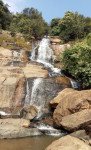
Ajodhya Hills Dams & Bamni Falls
Some quick example text to build on the card title and make up the bulk of the card's content.
Go somewhere
Ajodhya Pahar Hairpin View Point
Some quick example text to build on the card title and make up the bulk of the card's content.
Go somewhere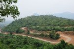
Ayodhya Hills
Some quick example text to build on the card title and make up the bulk of the card's content.
Go somewhere
Bamni Falls
Some quick example text to build on the card title and make up the bulk of the card's content.
Go somewhere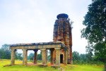
Banda Deul
Some quick example text to build on the card title and make up the bulk of the card's content.
Go somewhere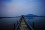
Baranti Reservoir
Some quick example text to build on the card title and make up the bulk of the card's content.
Go somewhere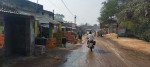
Begunkodar
Some quick example text to build on the card title and make up the bulk of the card's content.
Go somewhere
Charidah
Some quick example text to build on the card title and make up the bulk of the card's content.
Go somewhere
Deulghata Temple Ruins
Some quick example text to build on the card title and make up the bulk of the card's content.
Go somewherein Other Cities