Shamator
General information
-
Ideal Duration:
2 to 3 DaysPlace Type:
Offbeat / Tribal HeritageEntry Fees:
Public Access: There are currently no official entry fees for visiting the town of Shamator or its surrounding natural areas. Most of the tourism here is community-based, and access to villages is free. However, visitors are encouraged to contribute to village development ...Public Access: There are currently no official entry fees for visiting the town of Shamator or its surrounding natural areas. Most of the tourism here is community-based, and access to villages is free. However, visitors are encouraged to contribute to village development funds if they stay overnight.
Guide Services: Since the area is remote and the terrain is complex, hiring a local guide is highly recommended. A typical daily rate for a guide ranges from INR 800 to 1200. This fee often includes the guide's knowledge of local shortcuts and tribal customs, which is invaluable for a smooth trip.
:Timing:
Town Timings: Shops and local markets usually open around 08:30 AM and close by 04:30 PM. In this remote region, the day starts and ends with the sun. It is important to complete your inter-village travel well before dark for safety and navigation reasons.Town Timings: Shops and local markets usually open around 08:30 AM and close by 04:30 PM. In this remote region, the day starts and ends with the sun. It is important to complete your inter-village travel well before dark for safety and navigation reasons.
Ideal Visit Time: The best time for sightseeing is from 09:00 AM to 03:00 PM when the visibility is highest. If you are visiting during the festival months, events often start early in the morning and continue throughout the day. Plan your visits to remote villages carefully to ensure you return to your base before dusk.
:Special Events:
Metemneo Festival: This is the premier festival of the Yimkhiung tribe, celebrated in August after the harvest. It is a time for sharing food, making peace, and remembering the departed. The festival features vibrant dances and the traditional drinking of rice beer.Metemneo Festival: This is the premier festival of the Yimkhiung tribe, celebrated in August after the harvest. It is a time for sharing food, making peace, and remembering the departed. The festival features vibrant dances and the traditional drinking of rice beer.
Tsungkamneo Festival: Celebrated by the Yimkhiung in January, this festival marks the end of the year and the preparation for the new agricultural cycle. It is characterized by community singing and rituals to ensure a good harvest in the coming year.
:Best Photo Spots:
Zungki River Bridge: The bridge over the Zungki River offers a dramatic perspective of the river carving through the mountains. It is a great spot for wide-angle landscape shots, especially during the early morning or late afternoon. The rugged cliffs and the rushing water...Zungki River Bridge: The bridge over the Zungki River offers a dramatic perspective of the river carving through the mountains. It is a great spot for wide-angle landscape shots, especially during the early morning or late afternoon. The rugged cliffs and the rushing water create a powerful visual.
Traditional Village Gates: The entrance gates of the older villages are often decorated with skulls and carvings, making for a striking and culturally rich photo. These gates represent the history and the protective spirit of the village. They are best photographed in the soft light of the morning.
Ridge-top Viewpoints: Any of the high ridges around Shamator town provide a 360-degree view of the undulating hills. During the monsoon, the clouds floating below the peaks create a surreal and heavenly landscape for photography. These spots are perfect for capturing the vastness of the Naga hills.
:Photo Gallery
Things To Do
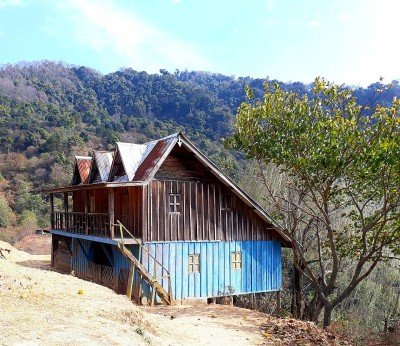 The Fakim Wildlife Sanctuary is a pristine protected area established in 1983 and spans approximately 642 hectares. It is located at an altitude ranging from 1,700 to 3,000 meters above sea level, making it a high-altitude ecological haven. The sanctuary is famous for its dense virgin forests, which include wet temperate and sub-alpine vegetation. It is home to rare fauna such as the Blyth’s Tragopan, the state bird of Nagaland, as well as panthers, Himalayan bears, and Hoolock gibbons. The landscape is characterized by high ridges and deep gorges that offer spectacular views of the surrounding mountains. Being part of the Indo-Burma biodiversity hotspot, it attracts researchers and nature lovers from across the globe. Visitors can witness a variety of rare orchids and medicinal plants that thrive in the heavy rainfall zone. The sanctuary also plays a vital role in community-led conservation efforts involving local tribes. :
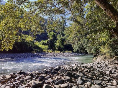 @@ Natural Sanctuary: Located a few kilometers downstream from the main crossing, this wide valley basin offers a tranquil setting where the river slows down and creates shallow, sandy beaches. @@ Lush Environment: The spot is surrounded by virgin forests and small agricultural clearings where locals grow millet and beans, creating a picturesque tapestry of green and gold against the blue water. @@ Recreational Focus: This area has been traditionally used by the people of Shamator for community outings and school picnics, offering a flat and safe terrain for children to play and families to relax. @@ Ecological Wealth: The valley is a hotspot for biodiversity, with many species of butterflies and wildflowers lining the banks, making it a peaceful retreat for those looking to connect with nature. :
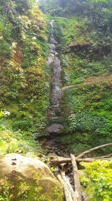 The Shamator Waterfall, also known locally as the Aisayak Waterfall, is a seasonal natural wonder that comes to life during and after the monsoon months. This hidden gem is tucked away in a lush green ravine, surrounded by dense virgin forests. The water drops from a height of approximately 80 feet into a clear rocky pool below. During the peak of the rainy season, the roar of the water can be heard from a distance, creating a sense of awe. The trek to the waterfall involves a moderate hike through spice gardens and traditional Jhum fields. This journey offers a glimpse into the agricultural life of the Naga people. The air near the falls is incredibly fresh and misty, providing a natural cooling effect. It is a favorite spot for local youths for weekend excursions and nature photography. The water is pristine, originating from the high mountain springs above. Since it is seasonal, the falls are most impressive from June to October. In the dry winter months, the flow reduces to a gentle trickle, but the rock formations remain a sight to behold. The path to the waterfall is often slippery, requiring careful navigation. Local legends speak of mountain spirits that guard the waters, adding a layer of mysticism to the site. It is an ideal spot for those looking to disconnect from technology and reconnect with nature. The biodiversity around the falls is rich, with various orchids and wild ferns growing in abundance. Visiting this waterfall is a refreshing adventure that highlights the raw beauty of eastern Nagaland.:
 Kiphire Town serves as the gateway to the highest peak in Nagaland and is the administrative heart of the Kiphire district. It is located at an elevation of 896 meters and is the meeting point for the Sangtam, Yimkhiung, and Sema tribes. The town is famous for its vibrant local markets where one can find traditional Naga shawls and organic produce like king chilies. Historically, it was part of the Tuensang district before being carved out as a separate entity. The town is surrounded by lush green hills and offers a base for treks to Mount Saramati. Visitors can explore the Kiphire Village Museum which houses artifacts from the head-hunting era. The town provides a glimpse into the diverse cultural tapestry of Eastern Nagaland, making it a crucial stop for any traveler. :
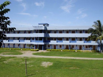 @@Heart of Local Life: The Shamator High School Ground is more than just a playground; it is the heartbeat of the town's social life. It serves as the primary venue for football matches, which are a passion in Nagaland. During the day, students use it for sports and physical training. In the evenings, it becomes a communal space for residents to walk and socialize. The ground is surrounded by hilly slopes that act as natural galleries for spectators. Major district-level events and independence day celebrations are held here. It provides a panoramic view of the school’s traditional buildings. The soil is red and dusty, typical of the Naga hills. It is the best place to witness the vibrant energy of the local youth. The ground often echoes with the sounds of cheering and local folk music during festivities.
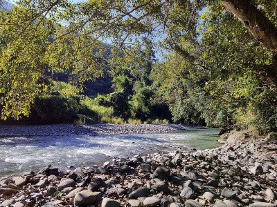 @@ Geographic Significance: This point marks where the main road crosses the Zungki River, the largest tributary in the region, serving as a vital link between Shamator and the neighboring districts. @@ Natural Beauty: The river here is wide and powerful, with clear turquoise water flowing over a bed of smooth river stones, surrounded by towering cliffs and dense subtropical forests that teem with life. @@ Engineering Marvel: The site features a combination of old suspension bridges and modern concrete structures that demonstrate the evolution of connectivity in these challenging mountainous terrains over the decades. @@ Local Life: This is a place where you can see the intersection of modern transport and traditional lifestyles, as villagers often use the river banks for fishing and traditional gold panning activities. :
 @@ Geographic Wonder: Shamator Peak stands as the highest elevation in the immediate vicinity, offering a commanding view of the entire district and acting as a natural landmark for travelers and locals alike. @@ Flora and Fauna: The slopes are covered in thick rhododendron forests and alpine vegetation, which burst into color during the spring, attracting a variety of high-altitude birds and butterflies. @@ Climate: Due to its height, the peak experiences a significantly cooler micro-climate, often being shrouded in clouds during the afternoon, creating a surreal and refreshing environment for trekkers. @@ Strategic Importance: Historically, the peak served as a lookout point for tribal warriors to monitor movements in the valley, and today it houses a small telecommunication tower and a viewing deck for tourists. :Show All
The Shamator Community Hall is the cultural and political nerve center of the district. This massive facility was built to accommodate the large gatherings of the Yimkhiung and Tikhir tribes, who use it for everything from tribal councils to wedding celebrations. The hall is a symbol of the "Brotherhood" spirit that defines the district. It is here that major decisions regarding local governance and peace treaties are discussed. For a visitor, the hall offers a deep dive into the socio-political structure of the Naga tribes. The interior is often decorated with traditional motifs, animal skulls (from historical significance), and vibrant tribal shawls. It overlooks the town's main football ground, making it a prime spot during sporting events. The hall also serves as an indoor venue for the Metiimnyo Festival when it rains. Its importance cannot be overstated; it is the "People's Parliament" of Shamator. Visitors can often see elders dressed in full traditional regalia attending meetings here. The hall provides a rare glimpse into the "Living Culture" of Nagaland, where ancient tribal traditions blend with modern democratic processes. It is a place of stories, where the oral history of the Naga people is passed down to the next generation in loud, rhythmic speeches.
Information
-
Why Famous:
Brotherhood and Unity: Shamator is famous for the "Brotherhood" spirit between the Yimkhiung and Tikhir tribes. It is a place that celebrates peace and mutual respect, which is a key part of its local identity.
Zungki River: The district is...Brotherhood and Unity: Shamator is famous for the "Brotherhood" spirit between the Yimkhiung and Tikhir tribes. It is a place that celebrates peace and mutual respect, which is a key part of its local identity.
Zungki River: The district is famous for the Zungki River, which offers some of the most dramatic riverine landscapes in eastern Nagaland. It is a major geographic feature that defines the topography of the entire region.
: -
Architecture:
Hill-Top Settlements: Architecture in Shamator is influenced by the need for security and community living on steep terrain. Traditional houses are built using locally sourced timber, bamboo, and thatch, often clustered together on hilltops. These houses feature a large ce...Hill-Top Settlements: Architecture in Shamator is influenced by the need for security and community living on steep terrain. Traditional houses are built using locally sourced timber, bamboo, and thatch, often clustered together on hilltops. These houses feature a large central room with a fireplace that serves as the heart of the home. The roofs are steeply pitched to handle the heavy monsoon rains typical of the region. A standard family dwelling in a village has dimensions of about 30x18 feet.
Functional Design: Modern structures in the town utilize brick and corrugated metal sheets, reflecting a shift toward more permanent materials. The government administrative buildings and schools are designed with large windows to allow for natural light. Community halls are built to accommodate large tribal gatherings and are often decorated with traditional motifs. The town's main church is a landmark, featuring a blend of modern design and local aesthetics. The church interior spans roughly 70x45 feet, providing a spacious area for worship.
: -
How To Reach:
By Air: The nearest airport is in Dimapur (350 KMS). From Dimapur, travelers must first reach Tuensang or Kiphire and then take a local taxi to Shamator. This is a multi-day journey that requires careful planning and stops in intermediate towns.
Read MoreBy Air: The nearest airport is in Dimapur (350 KMS). From Dimapur, travelers must first reach Tuensang or Kiphire and then take a local taxi to Shamator. This is a multi-day journey that requires careful planning and stops in intermediate towns.
By Train: Dimapur Railway Station is the closest rail connection. The journey from the station to Shamator involves a long road trip through the heart of Nagaland. It is advisable to use a robust 4x4 vehicle for the latter part of the journey as the roads can be very rough.
By Road: Shamator is connected by road to Tuensang and Kiphire. State transport buses and shared Sumo taxis run between these towns, but services can be infrequent. The roads are mountainous and prone to landslides during the monsoon, so checking the weather is crucial.
Local Transport: Within the district, shared taxis are the primary means of moving between villages. In the town area, walking is the most practical way to get around. For reaching specific remote spots or riverbanks, hiring a dedicated local taxi for the day is the best option for flexibility and safety.
:Weather and Best Time to Visit:
Dry Season: November to April is the best time to visit as the roads are more reliable and the weather is clear. This period is ideal for trekking, river visits, and outdoor photography. The cool temperatures make it comfortable for long days of exploration.Dry Season: November to April is the best time to visit as the roads are more reliable and the weather is clear. This period is ideal for trekking, river visits, and outdoor photography. The cool temperatures make it comfortable for long days of exploration.
Festival Season: Visiting during January or August allows you to witness the major tribal festivals. This is when the culture is most visible, with traditional dances and community feasts. It is a great time for those interested in cultural anthropology and photography.
Time of Day: Early morning is perfect for seeing the mist-covered valleys and catching the first light on the ridges. Late afternoon is the best time for village walks and interacting with the locals. Nights are usually spent indoors, enjoying local hospitality and stories around a fire.
:Near Tourist Places:
1. Tuensang (60 KMS), 2. Kiphire (55 KMS), 3. Mount Saramati (70 KMS), 4. Wansoi Village (15 KMS), 5. Zungki River (10 KMS), 6. Phunungre (20 KMS), 7. Noklak (80 KMS), 8. Phek (160 KMS), 9. Mokokchung (150 KMS), 10. Kohima (240 KMS).Tourism Tips
-
Health & Safety: This is a very remote area, so carry all necessary medicines and a first-aid kit. Access to modern medical facilities is limited to the town center. Always follow the advice of your local guide regarding forest trails and river safety, especially during th...Health & Safety: This is a very remote area, so carry all necessary medicines and a first-aid kit. Access to modern medical facilities is limited to the town center. Always follow the advice of your local guide regarding forest trails and river safety, especially during the rainy season.
Packing Needs: Heavy woolens are essential for the winters, while light cotton and a sturdy raincoat are needed for the rest of the year. Good quality hiking boots with ankle support are a must for the rocky and steep terrain. Carry a high-capacity power bank and a good flashlight, as power outages can occur.
Accommodation Tips: Guest houses in Shamator are basic and few in number. Staying in a village homestay is often the best way to ensure a warm bed and traditional meals. It is important to book or arrange your stay in advance through local contacts or the tourism office.
Respecting Customs: The local tribes are very proud of their traditions, so always show respect and ask for permission before entering sacred areas or taking photos. Dress modestly and avoid any behavior that might be seen as disrespectful to tribal elders. A humble and friendly attitude will go a long way in making your visit memorable.
:
Reviews
FAQs
Shamator Itineray And Cost:-
Other Places In Nagaland :-
Other States In India :-
Information about New and Updated Locations() of Nagaland Has Been Added :-
Card subtitle
Note:-
Information provided here in good Faith and for reference only.
Near Places
Dimapur
Some quick example text to build on the card title and make up the bulk of the card's content.
Go somewhere
Dzulekie
Some quick example text to build on the card title and make up the bulk of the card's content.
Go somewhere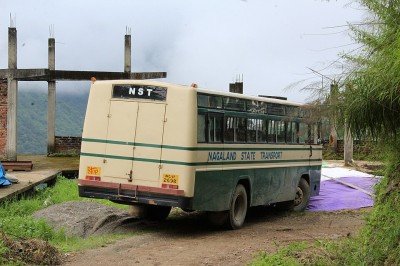
Khonoma
Some quick example text to build on the card title and make up the bulk of the card's content.
Go somewhere
Kigwema
Some quick example text to build on the card title and make up the bulk of the card's content.
Go somewhere
Kiphire
Some quick example text to build on the card title and make up the bulk of the card's content.
Go somewhere
Kohima
Some quick example text to build on the card title and make up the bulk of the card's content.
Go somewhere
Longleng
Some quick example text to build on the card title and make up the bulk of the card's content.
Go somewhere
Meluri
Some quick example text to build on the card title and make up the bulk of the card's content.
Go somewhere
Mokokchung
Some quick example text to build on the card title and make up the bulk of the card's content.
Go somewhere
Mon
Some quick example text to build on the card title and make up the bulk of the card's content.
Go somewhere
Mopungchuket
Some quick example text to build on the card title and make up the bulk of the card's content.
Go somewhere
Nagaland Heritage Village
Some quick example text to build on the card title and make up the bulk of the card's content.
Go somewhere
Niuland
Some quick example text to build on the card title and make up the bulk of the card's content.
Go somewhere
Noklak
Some quick example text to build on the card title and make up the bulk of the card's content.
Go somewhere
Peren
Some quick example text to build on the card title and make up the bulk of the card's content.
Go somewhere
Zunheboto
Some quick example text to build on the card title and make up the bulk of the card's content.
Go somewherein Other Cities